
Columbia, Alabama facts for kids
Quick facts for kids
Columbia, Alabama
|
|
|---|---|

Columbia, Alabama in 2012
|
|

Location of Columbia in Houston County, Alabama.
|
|
| Country | United States |
| State | Alabama |
| County | Houston |
| Area | |
| • Total | 4.00 sq mi (10.35 km2) |
| • Land | 3.93 sq mi (10.18 km2) |
| • Water | 0.07 sq mi (0.17 km2) |
| Elevation | 223 ft (68 m) |
| Population
(2020)
|
|
| • Total | 690 |
| • Density | 175.53/sq mi (67.77/km2) |
| Time zone | UTC-6 (Central (CST)) |
| • Summer (DST) | UTC-5 (CDT) |
| ZIP code |
36319
|
| Area code(s) | 334 |
| FIPS code | 01-16744 |
| GNIS feature ID | 0116457 |
Columbia is a small town in Houston County, Alabama, in the United States. It's part of the larger Dothan area. In 2020, about 690 people lived there. Columbia is known for its rich history and being one of the oldest towns in the region.
Contents
History of Columbia, Alabama
Columbia was founded a long time ago, in 1820. For many years, from 1822 to 1833, it was a very important place for trading goods in the Wiregrass Region of Alabama. During this time, Columbia was even the main town, or "county seat," for Henry County. Henry County used to be much bigger than it is today, covering parts of many other counties.
In 1833, Columbia stopped being the county seat. The main office moved to Abbeville.
Columbia's River Port Days
Columbia is located right next to the state of Georgia and the Chattahoochee River. Because of this, it was a busy port where steamboats would stop. People often called it "Old Columbia." The town officially became a town on April 29, 1880. It was a center for learning, culture, business, and trade. Columbia was the biggest town in the area during the 1800s. It is still one of the oldest towns that has been continuously operating.
Growth and Changes in Columbia
Columbia got its first factory for making cotton cloth in 1891. A year later, in 1892, it got its first electric power plant. From 1889, a branch of the Henry County Courthouse was in Columbia. This lasted until 1903, when Columbia became part of the new Houston County. The town even had electric street lights by 1900. Its first electric company started in 1914.
Around the year 1900, a new railway was built. It went through Dothan instead of Columbia. As trains became more popular for moving goods than riverboats, Columbia's importance as a trade center started to lessen. However, Columbia continued to be a strong farming community through the middle of the 1900s.
Old Columbia Jail: A Historic Building
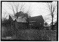
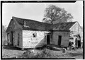
The Old Columbia Jail was built in the early 1860s. It is one of the very few wooden jails left in Alabama today. It originally had two cells, each about 10 by 15 feet in size. The inside walls were built with iron spikes every two inches. This was to stop prisoners from escaping. Today, local groups have fixed up the building. It is now a museum that shows off historical items from Columbia.

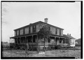
Purcell-Killingsworth House: A Grand Home
The Purcell-Killingsworth House is also known as "Traveler's Rest." It was finished in 1890 by William Henry Purcell. He was an important businessman and politician in Columbia. Mr. Purcell owned many businesses, including a steamboat landing on the Chattahoochee River. This house was the childhood home of Bishop Clare Purcell. He became a very important leader in the Methodist Church in 1955.
In 1946, the Purcell family sold the house. The new owners, Mr. and Mrs. Henry Killingsworth, carefully restored this large Victorian style house. It was added to the National Register of Historic Places on December 16, 1982.

Geography of Columbia
Columbia is located in the very northeastern part of Houston County. It sits right on the border between Alabama and Georgia.
The main roads that go through Columbia are Alabama State Route 52 and Alabama State Route 95. AL-52 goes east about 1 mile to the Georgia border. It goes west about 10 miles to Webb. AL-95 starts in Columbia and goes north about 23 miles to Abbeville. Another road, Alabama State Route 134, also starts here. It goes west about 17 miles to Headland.
The town covers a total area of about 4.0 square miles (10.35 square kilometers). Most of this area is land, and a small part is water.
Population of Columbia
| Historical population | |||
|---|---|---|---|
| Census | Pop. | %± | |
| 1880 | 290 | — | |
| 1890 | 960 | 231.0% | |
| 1900 | 1,132 | 17.9% | |
| 1910 | 1,122 | −0.9% | |
| 1920 | 860 | −23.4% | |
| 1930 | 926 | 7.7% | |
| 1940 | 829 | −10.5% | |
| 1950 | 849 | 2.4% | |
| 1960 | 783 | −7.8% | |
| 1970 | 891 | 13.8% | |
| 1980 | 881 | −1.1% | |
| 1990 | 922 | 4.7% | |
| 2000 | 804 | −12.8% | |
| 2010 | 740 | −8.0% | |
| 2020 | 690 | −6.8% | |
| U.S. Decennial Census 2013 Estimate |
|||
Who Lives in Columbia?
The 2020 United States census counted 690 people living in Columbia. There were 343 households and 192 families in the town.
| Race | Num. | Perc. |
|---|---|---|
| White (non-Hispanic) | 529 | 76.67% |
| Black or African American (non-Hispanic) | 117 | 16.96% |
| Asian | 1 | 0.14% |
| Other/Mixed | 40 | 5.8% |
| Hispanic or Latino | 3 | 0.43% |
Famous People from Columbia
- Dave Edwards: A former football player for Auburn University and the Dallas Cowboys.
- Monte Irvin: Born in Columbia, he became a member of the Baseball Hall of Fame.
- B'Ho Kirkland: Born in Columbia, he played football for the Alabama Crimson Tide and later for the Brooklyn Dodgers (NFL).
- Clare Purcell: Born in Columbia, he was an American Bishop in the Methodist Church. He was elected in 1938.
Images for kids
-
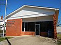
Columbia Post Office (ZIP code: 36319)
-
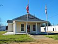
Rossie Purcell Public Library
-
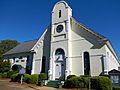
Columbia First Baptist Church
-
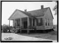
S. M. Dunwoody House.
-
Tom Bowden House.
-
J. B. Taylor House.
-
Teague-Regell House.


See also
 In Spanish: Columbia (Alabama) para niños
