
Headland, Alabama facts for kids
Quick facts for kids
Headland
|
||
|---|---|---|
|
City
|
||

This statue of a World War I doughboy, with his arm outstretched, honors all of Headland's military dead. It stands at the center of Headland Public Square.
|
||
|
||

Location of Headland in Henry County, Alabama.
|
||
| Country | United States | |
| State | Alabama | |
| County | Henry | |
| Area | ||
| • Total | 30.34 sq mi (78.58 km2) | |
| • Land | 30.33 sq mi (78.56 km2) | |
| • Water | 0.01 sq mi (0.03 km2) | |
| Elevation | 385 ft (117 m) | |
| Population
(2020)
|
||
| • Total | 4,973 | |
| • Density | 163.96/sq mi (63.31/km2) | |
| Time zone | UTC−6 (Central (CST)) | |
| • Summer (DST) | UTC−5 (CDT) | |
| ZIP code |
36345
|
|
| Area code | 334 | |
| FIPS code | 01-33856 | |
| GNIS feature ID | 0119910 | |

Headland is the biggest city in Henry County, Alabama, in the United States. It's part of the larger Dothan area. In 2020, about 4,973 people lived there. This was more than the 4,510 people counted in 2010.
Contents
History of Headland
Headland was founded in 1871 by James Joshua Head. He called it "Head's Land" at first. Mr. Head bought the land, planned out the town, and built his home there. The first post office in Headland opened on October 10, 1871.
In 1871, Mr. Head also designed the Headland Public Square. He hoped it would be a place for a branch courthouse. However, people in Henry County voted in 1879 and 1885 not to put a courthouse there.
James Joshua Head sold Headland to Hosey C. Powell in 1879. Then, Dr. Wyatt S. Oates bought it in 1880. Mr. Head later moved to Tampa, Florida, in 1883.
Headland officially became a town in 1884. A railroad was built in 1893, along with the Seaboard Coast Line Railroad Depot. This depot was added to the National Register of Historic Places in 1980. It has since been taken apart.
The Spirit of the American Doughboy statue in Headland was the first public statue in Henry County. It was put up in the town square in 1926. This statue honors the soldiers from Headland who died in wars. The town square was paved in 1935.
By the 1960 census, Headland had become the largest city in Henry County. It was slightly bigger than Abbeville. Headland lost this title to Abbeville in 1970 but got it back in 1980. Since then, it has remained the largest city. In 2000, Headland's population grew to 3,523, which was more than Dothan's record for Henry County in 1900. By 2010, nearly 1,000 more people lived in Headland.
Geography and Climate
Headland is located in the southwest part of Henry County. It is at 31°21′12″N 85°20′23″W / 31.35333°N 85.33972°W. To the south, it borders the city of Dothan and the town of Kinsey. These are both in Houston County. To the west, Headland borders Dale County.
U.S. Route 431 is a four-lane highway that runs through the east side of Headland. It goes south about 10 miles (16 km) to the center of Dothan. North, it goes about 18 miles (29 km) to Abbeville. Alabama State Route 134 goes through the middle of Headland. It leads east about 16 miles (26 km) to Columbia, which is near the Georgia border. To the west, it goes about 10 miles (16 km) to Midland City.
The U.S. Census Bureau says that Headland covers a total area of 78.5 square kilometers (30.3 square miles). Only a very small part, about 0.03 square kilometers (0.01 square miles), is water.
Headland Climate
| Climate data for Headland, Alabama, 1991–2020 normals, extremes 1950–2022 | |||||||||||||
|---|---|---|---|---|---|---|---|---|---|---|---|---|---|
| Month | Jan | Feb | Mar | Apr | May | Jun | Jul | Aug | Sep | Oct | Nov | Dec | Year |
| Record high °F (°C) | 84 (29) |
87 (31) |
89 (32) |
94 (34) |
100 (38) |
104 (40) |
108 (42) |
106 (41) |
101 (38) |
98 (37) |
88 (31) |
84 (29) |
108 (42) |
| Mean maximum °F (°C) | 76.0 (24.4) |
78.9 (26.1) |
84.1 (28.9) |
88.2 (31.2) |
93.5 (34.2) |
97.3 (36.3) |
98.0 (36.7) |
97.5 (36.4) |
94.9 (34.9) |
89.3 (31.8) |
82.5 (28.1) |
77.9 (25.5) |
99.1 (37.3) |
| Mean daily maximum °F (°C) | 60.5 (15.8) |
64.8 (18.2) |
72.2 (22.3) |
79.0 (26.1) |
86.6 (30.3) |
91.0 (32.8) |
92.8 (33.8) |
91.7 (33.2) |
88.5 (31.4) |
79.9 (26.6) |
70.3 (21.3) |
62.7 (17.1) |
78.3 (25.7) |
| Daily mean °F (°C) | 49.4 (9.7) |
53.1 (11.7) |
59.8 (15.4) |
66.2 (19.0) |
74.7 (23.7) |
80.2 (26.8) |
82.2 (27.9) |
81.2 (27.3) |
77.4 (25.2) |
67.9 (19.9) |
58.4 (14.7) |
51.8 (11.0) |
66.9 (19.4) |
| Mean daily minimum °F (°C) | 38.2 (3.4) |
41.3 (5.2) |
47.4 (8.6) |
53.5 (11.9) |
62.8 (17.1) |
69.4 (20.8) |
71.6 (22.0) |
70.6 (21.4) |
66.2 (19.0) |
55.9 (13.3) |
46.5 (8.1) |
40.8 (4.9) |
55.4 (13.0) |
| Mean minimum °F (°C) | 21.0 (−6.1) |
24.8 (−4.0) |
29.9 (−1.2) |
38.7 (3.7) |
48.7 (9.3) |
60.9 (16.1) |
65.8 (18.8) |
63.7 (17.6) |
54.3 (12.4) |
38.7 (3.7) |
28.6 (−1.9) |
25.2 (−3.8) |
18.4 (−7.6) |
| Record low °F (°C) | 0 (−18) |
10 (−12) |
12 (−11) |
27 (−3) |
41 (5) |
45 (7) |
51 (11) |
54 (12) |
39 (4) |
26 (−3) |
15 (−9) |
5 (−15) |
0 (−18) |
| Average precipitation inches (mm) | 4.80 (122) |
5.15 (131) |
4.83 (123) |
4.61 (117) |
3.65 (93) |
5.16 (131) |
6.73 (171) |
5.07 (129) |
4.59 (117) |
3.16 (80) |
3.87 (98) |
5.10 (130) |
56.72 (1,442) |
| Average snowfall inches (cm) | 0.0 (0.0) |
0.1 (0.25) |
0.0 (0.0) |
0.0 (0.0) |
0.0 (0.0) |
0.0 (0.0) |
0.0 (0.0) |
0.0 (0.0) |
0.0 (0.0) |
0.0 (0.0) |
0.0 (0.0) |
0.0 (0.0) |
0.1 (0.25) |
| Average precipitation days (≥ 0.01 in) | 10.5 | 9.7 | 8.9 | 7.4 | 7.5 | 12.0 | 13.6 | 12.6 | 7.8 | 6.2 | 7.8 | 9.6 | 113.6 |
| Average snowy days (≥ 0.1 in) | 0.0 | 0.1 | 0.0 | 0.0 | 0.0 | 0.0 | 0.0 | 0.0 | 0.0 | 0.0 | 0.0 | 0.0 | 0.1 |
| Source 1: NOAA | |||||||||||||
| Source 2: National Weather Service | |||||||||||||
Population of Headland
| Historical population | |||
|---|---|---|---|
| Census | Pop. | %± | |
| 1900 | 602 | — | |
| 1910 | 1,090 | 81.1% | |
| 1920 | 1,252 | 14.9% | |
| 1930 | 1,811 | 44.6% | |
| 1940 | 2,052 | 13.3% | |
| 1950 | 2,091 | 1.9% | |
| 1960 | 2,650 | 26.7% | |
| 1970 | 2,545 | −4.0% | |
| 1980 | 3,327 | 30.7% | |
| 1990 | 3,266 | −1.8% | |
| 2000 | 3,523 | 7.9% | |
| 2010 | 4,510 | 28.0% | |
| 2020 | 4,973 | 10.3% | |
| U.S. Decennial Census 2013 Estimate |
|||
2010 Census Information
According to the 2010 census, Headland had 4,510 people living there. There were 1,799 households and 1,291 families. About 70.1% of the people were White, and 27.5% were Black or African American. A small number were Native American (0.4%), Asian (0.3%), or from other races (0.6%). About 1.2% were from two or more races. People of Hispanic or Latino background made up 1.4% of the population.
2020 Census Information
| Race | Num. | Perc. |
|---|---|---|
| White (non-Hispanic) | 3,541 | 71.2% |
| Black or African American (non-Hispanic) | 1,168 | 23.49% |
| Native American | 6 | 0.12% |
| Asian | 24 | 0.48% |
| Other/Mixed | 176 | 3.54% |
| Hispanic or Latino | 58 | 1.17% |
As of the 2020 census, there were 4,973 people living in Headland. There were 1,583 households and 1,131 families.
Education in Headland
Headland is part of the Henry County Public Schools system. The city has three main schools:
- Headland Elementary School (for grades K-5)
- Headland Middle School (for grades 6-9)
- Headland High School (for grades 10-12)
Sports in Headland
Headland used to have a Minor League Baseball team called the Headland Dixie Runners. They played in the Alabama State League/Alabama–Florida League from 1950 to 1952.
Headland was also home to the 2016 Dixie Youth Baseball World Champions. This means a team from Headland won a big baseball championship for young players that year!
Famous People from Headland
- M. Watt Espy: A historian who studied the death penalty.
- W. Thomas West: A former major general in the U.S. Air Force.
- Charles Woods: A businessman and political candidate.
Images for kids
-
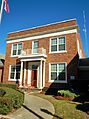
Headland City Hall (built in 1930)
-

Blanche R. Solomon Memorial Library
-
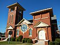
The First Baptist Church of Headland was first started in 1837.


See also
 In Spanish: Headland (Alabama) para niños
