Chattahoochee River facts for kids
Quick facts for kids Chattahoochee River |
|
|---|---|

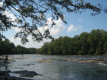
Chattahoochee River at Jones Bridge Park in Peachtree Corners, Georgia
|
|

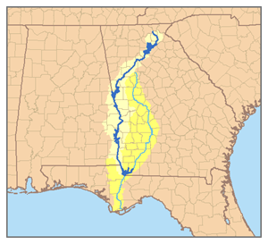
Map of the Apalachicola River system with the Chattahoochee highlighted in dark blue.
|
|
| Country | United States |
| State | Georgia, Alabama, Florida |
| Physical characteristics | |
| Main source | near Jacks Knob Blue Ridge Mountains, Chattahoochee National Forest, Georgia 3,550 ft (1,080 m) 34°49′26″N 83°47′28″W / 34.82389°N 83.79111°W |
| River mouth | Apalachicola River confluence with Flint River, near Jim Woodruff Dam 75 ft (23 m) 30°42′32″N 84°51′50″W / 30.70889°N 84.86389°W |
| Length | 430 mi (690 km) |
| Basin features | |
| Basin size | 8,770 sq mi (22,700 km2) |
The Chattahoochee River is a very important river in the southeastern United States. It forms part of the border between Alabama and Georgia. This river is about 430 miles (690 km) long.
The Chattahoochee River is a main branch of the Apalachicola River. Together with the Flint River, these three rivers form a large system. This system is known as the Apalachicola–Chattahoochee–Flint River Basin, or the ACF River Basin for short.
Contents
Where Does the Chattahoochee River Start?
The Chattahoochee River begins high up in the Blue Ridge Mountains. Its source is near a place called Jacks Knob in the Chattahoochee National Forest in Georgia. Here, the river starts at an elevation of about 3,550 ft (1,080 m).
From these mountains, the river flows south. It gathers water from many smaller streams as it travels.
The River's Long Journey
As the Chattahoochee River flows, it passes through many different areas. It goes through cities and towns, as well as quiet natural places. The river helps create the border between Georgia and Alabama for a long stretch.
Eventually, the Chattahoochee River meets another important river, the Flint River. This meeting point is near the Jim Woodruff Dam. When these two rivers join, they form the Apalachicola River. The Apalachicola River then continues its journey to the Gulf of Mexico.
Why is the Chattahoochee River Important?
The Chattahoochee River is vital for many reasons. It provides drinking water for millions of people, especially in the Atlanta metropolitan area. It also helps generate electricity through dams along its path.
The river is also a great place for fun activities. People enjoy boating, fishing, and kayaking on its waters. The areas around the river offer parks and trails for hiking and enjoying nature. It's a home for many different kinds of plants and animals too.
Images for kids
See also
 In Spanish: Río Chattahoochee para niños
 | Toni Morrison |
 | Barack Obama |
 | Martin Luther King Jr. |
 | Ralph Bunche |


