ACF River Basin facts for kids
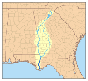
The ACF River Basin is a large area of land where all the rain and snowmelt drain into one main river system. It's like a giant funnel for water! This basin gets its name from the three main rivers that flow through it: the Apalachicola River, the Chattahoochee River, and the Flint River. These rivers are all found in the southeastern part of the United States.
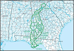
This important water area is also known as the Apalachicola Basin. The United States Geological Survey (a science agency) has given it a special code, HUC 031300, to help track it. It's part of an even bigger water region called the South Atlantic-Gulf Water Resource Region. The entire basin is divided into 14 smaller sections, like puzzle pieces, to help manage the water.
Contents
Where is the ACF River Basin?
The ACF River Basin starts high up in the mountains of northeast Georgia. From there, it collects water from many places, including big cities like Atlanta, and large parts of western and southwestern Georgia. It also drains water from some counties in southeastern Alabama.
The basin then flows south, splitting the central part of the Florida Panhandle. Finally, all this water empties into the Gulf of Mexico at Apalachicola Bay, near the town of Apalachicola, Florida. This huge area covers about 20,355 square miles (that's over 52,000 square kilometers!). On its eastern side, the basin is next to the Eastern Continental Divide, which is like a natural line that separates where water flows either to the Atlantic Ocean or the Gulf of Mexico.
Water Challenges and Solutions
The states of Georgia, Florida, and Alabama have been involved in a long-running disagreement about how to share the water from the ACF River Basin. This is often called the Tri-state water dispute. It's a tricky problem because everyone needs water for different reasons.
For example, Georgia has asked the government to stop boats from traveling on parts of the Apalachicola and lower Chattahoochee rivers during dry times. This is because keeping the rivers deep enough for boats means releasing a lot of water from dams upstream. This water could otherwise be used for drinking or keeping lakes full for recreation.
Protecting Nature and Resources
There are also important environmental and economic concerns in the basin. One big issue is protecting the oyster farms in Apalachicola Bay. Oysters need a good amount of fresh water flowing into the bay. If too much saltwater from the Gulf of Mexico gets in, it can harm the oysters.
Many rare and endangered animals, including special types of mussels, live in the basin. Protecting their homes is very important. Another problem is silt, which is like fine mud. A lot of silt washes into the rivers, especially from fast-growing areas around Atlanta. This silt has to be removed by dredging (digging it out) to keep the rivers clear, which costs a lot of money.
See Also
- Apalachicola River
- Chattahoochee River
- Flint River
- Tri-state water dispute
 | Sharif Bey |
 | Hale Woodruff |
 | Richmond Barthé |
 | Purvis Young |


