
Apalachicola, Florida facts for kids
Quick facts for kids
Apalachicola, Florida
|
||
|---|---|---|
| City of Apalachicola | ||

Dixie Theatre (2008)
|
||
|
||

Location within Franklin County and Florida
|
||

Apalachicola, Florida
Location in the United States
|
||
| Country | United States of America | |
| State | Florida | |
| County | Franklin | |
| Settled (Apalachicola) | c. 1705-1763 | |
| Settled (Cottonton) | c. 1763-1783 | |
| Incorporated (Town of West Point) | 1827 | |
| Incorporated (City of Apalachicola) | 1831 | |
| Government | ||
| • Type | Mayor–Commission | |
| Area | ||
| • Total | 2.63 sq mi (6.80 km2) | |
| • Land | 1.93 sq mi (4.99 km2) | |
| • Water | 0.70 sq mi (1.81 km2) | |
| Elevation | 13 ft (4 m) | |
| Population
(2020)
|
||
| • Total | 2,341 | |
| • Density | 1,216.10/sq mi (469.61/km2) | |
| Time zone | UTC−5 (Eastern (EST)) | |
| • Summer (DST) | UTC−4 (EDT) | |
| ZIP codes |
32320, 32329
|
|
| Area code(s) | 850 | |
| FIPS code | 12-01625 | |
| GNIS ID | 0277920 | |

Apalachicola (pronounced AP-ə-LACH-i-KOH-lə) is a city in Franklin County, Florida, United States. It is also the county seat, which means it's where the local government offices are. The city sits on the shore of Apalachicola Bay, which is a part of the Gulf of Mexico. In 2020, about 2,341 people lived there.
Contents
History of Apalachicola


The name "Apalachicola" comes from the Hitchiti language. It means "people on the other side of the river." This name was first used for a group of people living along the Chattahoochee River.
Early Settlements and European Control
From 1513 to 1763, the area of Apalachicola was controlled by Spanish Florida. The Spanish built a fort here around 1705. Later, during the French and Indian War, the British took control of Cuba. Spain traded Florida to the British to get Cuba back.
So, from 1763 to 1783, the area was part of British West Florida. A British trading post called "Cottonton" was set up at the mouth of the Apalachicola River. Even when the Spanish got Florida back in 1783, the trading post kept going.
Becoming a Town
Over time, more European-American settlers moved to the area. In 1827, the town was officially named "West Point." Then, in 1831, it was renamed "Apalachicola" by the Florida government.
Trinity Episcopal Church
Trinity Episcopal Church was built in 1837. It was one of the first prefabricated buildings in the United States. Its parts were made in New York City and shipped by boat. Workers then put it together in Apalachicola using wooden pegs.
Important Discoveries and Trade
In 1847, a botanist named Alvan Wentworth Chapman moved to Apalachicola. He wrote an important book about plants in the Southern United States.
Apalachicola was once a very busy port on the Gulf of Mexico. It was the third busiest, after New Orleans and Mobile. Boats carried people and goods up and down the Apalachicola River, Chattahoochee River, and Flint River.
The Invention of Refrigeration
In 1849, a doctor in Apalachicola named John Gorrie made a big discovery. He found a way to create cold air and patented an ice machine in 1850. He wanted to help his patients with fevers by cooling them down. His invention helped create modern refrigeration and air conditioning. This made places like Florida much more comfortable to live in all year.
Today, there's a monument to Dr. Gorrie in the city. You can also see a copy of his ice machine at the John Gorrie Museum. The main bridge out of Apalachicola, U.S. 98, is named the John Gorrie Memorial Bridge in his honor.
Civil War and Transportation
During the American Civil War, Union forces captured Apalachicola in 1862. They stayed in the area for much of the war.
Today, the AN Railway (formerly Apalachicola Northern Railroad) still serves the city. The John Gorrie Memorial Bridge connects Apalachicola to Eastpoint across Apalachicola Bay. It was first built in 1935 and rebuilt in 1988.
Geography of Apalachicola

Apalachicola is located in the northwest part of Florida. It sits right on Apalachicola Bay where the Apalachicola River flows into it.
U.S. 98 is the main highway. It goes east across the bay to Eastpoint. To the northwest, it goes about 59 miles to Panama City. The state capital, Tallahassee, is about 75 miles northeast.
The city covers about 2.63 square miles (6.8 square kilometers). Most of this area is land, but about 26.67% is water.
Climate in Apalachicola
Apalachicola has a humid subtropical climate. This means it has short, mild winters and hot, humid summers. The hottest temperature ever recorded was 103°F (39°C) in August 1995. The coldest was 9°F (-13°C) in January 1985.
| Climate data for Apalachicola, Florida (Apalachicola Regional Airport), 1991–2020 normals, extremes 1995–present | |||||||||||||
|---|---|---|---|---|---|---|---|---|---|---|---|---|---|
| Month | Jan | Feb | Mar | Apr | May | Jun | Jul | Aug | Sep | Oct | Nov | Dec | Year |
| Record high °F (°C) | 80 (27) |
82 (28) |
90 (32) |
89 (32) |
98 (37) |
100 (38) |
102 (39) |
103 (39) |
98 (37) |
92 (33) |
89 (32) |
91 (33) |
103 (39) |
| Mean maximum °F (°C) | 75.1 (23.9) |
76.6 (24.8) |
81.3 (27.4) |
84.3 (29.1) |
91.6 (33.1) |
94.3 (34.6) |
95.7 (35.4) |
95.2 (35.1) |
92.1 (33.4) |
88.3 (31.3) |
82.3 (27.9) |
77.0 (25.0) |
97.1 (36.2) |
| Mean daily maximum °F (°C) | 63.7 (17.6) |
66.3 (19.1) |
70.9 (21.6) |
76.3 (24.6) |
83.7 (28.7) |
88.5 (31.4) |
89.7 (32.1) |
89.4 (31.9) |
86.7 (30.4) |
80.7 (27.1) |
72.5 (22.5) |
66.0 (18.9) |
77.9 (25.5) |
| Daily mean °F (°C) | 54.0 (12.2) |
56.8 (13.8) |
61.7 (16.5) |
67.3 (19.6) |
74.8 (23.8) |
80.7 (27.1) |
82.2 (27.9) |
82.2 (27.9) |
79.2 (26.2) |
71.5 (21.9) |
62.1 (16.7) |
56.5 (13.6) |
69.1 (20.6) |
| Mean daily minimum °F (°C) | 44.4 (6.9) |
47.4 (8.6) |
52.5 (11.4) |
58.2 (14.6) |
65.9 (18.8) |
72.8 (22.7) |
74.7 (23.7) |
75.0 (23.9) |
71.6 (22.0) |
62.3 (16.8) |
51.7 (10.9) |
47.1 (8.4) |
60.3 (15.7) |
| Mean minimum °F (°C) | 27.5 (−2.5) |
30.7 (−0.7) |
36.0 (2.2) |
43.7 (6.5) |
53.3 (11.8) |
66.4 (19.1) |
70.3 (21.3) |
70.1 (21.2) |
61.2 (16.2) |
45.4 (7.4) |
35.4 (1.9) |
31.7 (−0.2) |
25.6 (−3.6) |
| Record low °F (°C) | 9 (−13) |
23 (−5) |
22 (−6) |
36 (2) |
47 (8) |
48 (9) |
63 (17) |
62 (17) |
52 (11) |
33 (1) |
27 (−3) |
14 (−10) |
9 (−13) |
| Average precipitation inches (mm) | 4.06 (103) |
4.17 (106) |
4.34 (110) |
2.91 (74) |
1.87 (47) |
5.86 (149) |
5.74 (146) |
7.79 (198) |
5.38 (137) |
3.63 (92) |
3.74 (95) |
3.59 (91) |
53.08 (1,348) |
| Average precipitation days (≥ 0.01 in) | 9.8 | 8.8 | 7.9 | 6.5 | 5.7 | 11.1 | 15.0 | 15.3 | 11.5 | 7.8 | 8.9 | 10.1 | 118.4 |
| Mean monthly sunshine hours | 187.7 | 188.1 | 250.8 | 296.8 | 327.9 | 304.8 | 278.6 | 262.6 | 251.8 | 261.2 | 212.8 | 187.8 | 3,010.9 |
| Source: NOAA (sun 1961–1990) | |||||||||||||
People of Apalachicola
| Historical population | |||
|---|---|---|---|
| Census | Pop. | %± | |
| 1860 | 1,904 | — | |
| 1870 | 1,129 | −40.7% | |
| 1880 | 1,336 | 18.3% | |
| 1890 | 2,727 | 104.1% | |
| 1900 | 3,077 | 12.8% | |
| 1910 | 3,065 | −0.4% | |
| 1920 | 3,066 | 0.0% | |
| 1930 | 3,150 | 2.7% | |
| 1940 | 3,268 | 3.7% | |
| 1950 | 3,222 | −1.4% | |
| 1960 | 3,099 | −3.8% | |
| 1970 | 3,102 | 0.1% | |
| 1980 | 2,565 | −17.3% | |
| 1990 | 2,602 | 1.4% | |
| 2000 | 2,334 | −10.3% | |
| 2010 | 2,231 | −4.4% | |
| 2020 | 2,341 | 4.9% | |
| U.S. Decennial Census | |||
As of the 2020 United States census, 2,341 people lived in Apalachicola. There were 1,272 households and 669 families.
Most people in Apalachicola are White, making up about 61.60% of the population. Black or African Americans make up about 25.93%. Other groups, including Native Americans, Asians, and people of two or more races, make up smaller percentages. About 7.86% of the population is Hispanic or Latino.
Economy and Jobs

Apalachicola is still an important place for seafood workers. Many people work in recreational fishing and shrimping. In the past, Apalachicola Bay produced over 90% of Florida's oysters. However, the oyster industry has faced big challenges. It has almost completely stopped due to pollution and not enough fresh water flowing into the bay.
Every year, the city hosts the Florida Seafood Festival. The bay is naturally protected by several islands, including St. Vincent Island and St. George Island.
In 1979, a company called Exxon moved an experimental underwater oil system here. This was the first time an oil platform was turned into an artificial reef.
Arts and Culture
Apalachicola is home to the Dixie Theatre. This is a professional theater that also hosts live performances. The theater was built in 1912 and was fully renovated starting in 1996.
Education in Apalachicola
Students in Apalachicola attend schools in the Franklin County Schools system. Most students go to the K–12 Franklin County School. There is also a charter school in Apalachicola called Apalachicola Bay Charter School.
- Wallace M. Quinn High School
Notable People
- Jimmy Bloodworth – A professional baseball player.
- Alvin Wentworth Chapman – A famous botanist (plant scientist).
- John Gorrie – The inventor of mechanical cooling and the ice machine.
- Mary Rogers Gregory – An artist.
- Richard Heyser – A U-2 spy plane pilot.
Images for kids
-
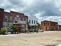
Dixie Theatre (2008)
-
Seal of Apalachicola
-
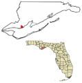
Location within Franklin County and Florida
See also
 In Spanish: Apalachicola (Florida) para niños
