
Autauga County, Alabama facts for kids
Quick facts for kids
Autauga County
|
|||
|---|---|---|---|

Autauga County Courthouse in Prattville
|
|||
|
|||

Location within the U.S. state of Alabama
|
|||
 Alabama's location within the U.S. |
|||
| Country | |||
| State | |||
| Founded | November 21, 1818 | ||
| Seat | Prattville | ||
| Largest city | Prattville | ||
| Area | |||
| • Total | 604 sq mi (1,560 km2) | ||
| • Land | 594 sq mi (1,540 km2) | ||
| • Water | 10 sq mi (30 km2) 1.6% | ||
| Population
(2020)
|
|||
| • Total | 58,805 | ||
| • Estimate
(2023)
|
60,342 |
||
| • Density | 97.36/sq mi (37.591/km2) | ||
| Time zone | UTC−6 (Central) | ||
| • Summer (DST) | UTC−5 (CDT) | ||
| Congressional district | 2nd | ||
|
|||

Autauga County is a county in the central part of Alabama, a state in the United States. It's a place with a rich history and a growing community.
As of the 2020 census, about 58,805 people live here. The main town and county seat is Prattville. Autauga County is also part of the larger Montgomery metropolitan area.
Contents
History of Autauga County
Autauga County was created on November 21, 1818. This was one year before Alabama became a state! When it was first formed, the county was much larger. It included parts of what are now Elmore County and Chilton County.
Native American Roots
Long ago, Native Americans lived in this area. The Autauga tribe, also known as the Tawasa, lived here. Their main village was called Atagi, which means "pure water." It was located by a creek that settlers later called "Pearl Water Creek." This creek flows into the Alabama River. Some people think the name Autauga comes from a Creek word, atigi, meaning "border."
The Autauga people were part of the Alibamu tribe. Later, they joined the Creek Confederacy. During the Creek War in 1812, many Autauga warriors fought to protect their land. After the war, in 1814, this land became part of the territory given up by the Creek Confederacy in the Treaty of Fort Jackson.
Changing County Seats
The first county seat was Jackson's Mill, but only for a short time. The leaders soon chose Washington as the permanent county seat. This new town was built on the old Atagi village site.
However, more people started moving to the western part of the county. So, in 1830, the county seat moved again to Kingston. The town of Washington slowly disappeared after losing its businesses and residents.
Daniel Pratt and Prattville
In 1833, a man named Daniel Pratt came to Autauga County. He started a new town called Prattville. It was located north of the old Atagi village.
Pratt's factory made cotton gins, which are machines that separate cotton fibers from seeds. His factory quickly became the biggest cotton gin maker in the world! It was the first major industry in Alabama.
Civil War and After
During the Civil War, Daniel Pratt helped form a fighting group called the Prattville Dragoons. Other groups from Autauga County also joined the Confederacy. Luckily, no battles of the Civil War took place in Autauga County.
After the war, Daniel Pratt was able to collect money owed to him from northern states. This helped the county recover faster than many other places in the South.
An important person after the war was Charles Atwood. He was a freedman, meaning he had been enslaved by Daniel Pratt. After slavery ended, he bought a house in Prattville. He even became an investor in Pratt's railroad company. It was very unusual for an African American to be so successful and own land in Alabama during that time.
County Changes and New Courthouses
In 1866 and 1868, parts of Autauga County were used to create Elmore and Chilton counties. With these changes, Prattville became the new county seat.
A new courthouse was built in Prattville in 1870. Later, in 1906, an even bigger courthouse was built. It was designed in a special style called Richardsonian Romanesque.
Geography of Autauga County
Autauga County covers about 604 square miles (1,564 square kilometers). Most of this area is land (594 sq mi), with about 10 square miles (26 sq km) of water.
The county is mostly in the Gulf Coastal Plain region. This means it has flat areas, but also some rolling hills and forests. This is because it's close to the fall line, a natural boundary where the land changes elevation.
Climate
Autauga County has a humid subtropical climate. This means it has hot, humid summers and mild winters.
Major Highways
These are the main roads that go through Autauga County:
 Interstate 65
 U.S. Highway 31
 U.S. Highway 82
 State Route 14
 State Route 111
 State Route 143
Neighboring Counties
Autauga County shares borders with these other counties:
- Chilton County - to the north
- Elmore County - to the east
- Montgomery County - to the southeast
- Lowndes County - to the south
- Dallas County - to the west
People of Autauga County (Demographics)
| Historical population | |||
|---|---|---|---|
| Census | Pop. | %± | |
| 1820 | 3,853 | — | |
| 1830 | 11,874 | 208.2% | |
| 1840 | 14,342 | 20.8% | |
| 1850 | 15,023 | 4.7% | |
| 1860 | 16,739 | 11.4% | |
| 1870 | 11,623 | −30.6% | |
| 1880 | 13,108 | 12.8% | |
| 1890 | 13,330 | 1.7% | |
| 1900 | 17,915 | 34.4% | |
| 1910 | 20,038 | 11.9% | |
| 1920 | 18,908 | −5.6% | |
| 1930 | 19,694 | 4.2% | |
| 1940 | 20,977 | 6.5% | |
| 1950 | 18,186 | −13.3% | |
| 1960 | 18,739 | 3.0% | |
| 1970 | 24,460 | 30.5% | |
| 1980 | 32,259 | 31.9% | |
| 1990 | 34,222 | 6.1% | |
| 2000 | 43,671 | 27.6% | |
| 2010 | 54,571 | 25.0% | |
| 2020 | 58,805 | 7.8% | |
| 2023 (est.) | 60,342 | 10.6% | |
| U.S. Decennial Census 1790–1960 1900–1990 1990–2000 2010–2020 |
|||
As of the 2020 United States census, Autauga County had 58,805 residents. There were 21,397 households and 15,076 families living in the county.
In 2010, the population density was about 91 people per square mile. Most people identified as White (78.5%), followed by Black or African American (17.7%). About 2.4% of the population was Hispanic or Latino.
The average age in the county in 2010 was 37 years old. About 26.8% of the population was under 18. The median income for a household was about $53,682. This means half of the households earned more than this, and half earned less.
Education in Autauga County
Autauga County has one main public school system. It's called the Autauga County School System. About 9,000 students attend public schools from kindergarten through 12th grade in the county.
There is also a private school, East Memorial Christian Academy. It is located near Prattville.
Fun Places to Visit
Autauga County has many parks where you can have fun! Some of these include:
- Wilderness Park
- Cooters Pond Park
- Pratt Park
- Swift Creek Park
- Newton Park
- Spinners Park
- Heritage Park
- Overlook Memorial Park
Communities
Autauga County has several towns and cities:
Cities
- Millbrook (most of this city is in Elmore County)
- Prattville
Towns
Census-designated place
Unincorporated communities
Ghost town
Notable People from Autauga County
- Samuel Smith Harris (1841-1888) - Born in Autauga County, he was a religious leader and a bishop.
- William Henry Lanier (1855-1929) - Born here, he was an important educator and served as president of Alcorn State University.
- Wilson Pickett (1941-2006) - Born in Prattville, Alabama, he was a famous singer known for songs like "In the Midnight Hour."
Images for kids
-
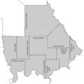
Approximate divisions used in the 1850 and 1860 censuses. The white dotted line represents the current county boundary.
-
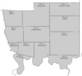
Approximate divisions used in the 1930 census. Similar to those used from 1900 to 1940.
-
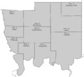
Approximate divisions used in the 1950 census.
-
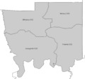
Current divisions as of the 2020 census, in use since at least 1990.
See also
 In Spanish: Condado de Autauga para niños
