Elmore County, Alabama facts for kids
Quick facts for kids
Elmore County
|
||
|---|---|---|

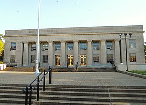
Elmore County Courthouse in Wetumpka
|
||
|
||

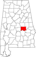
Location within the U.S. state of Alabama
|
||
 Alabama's location within the U.S. |
||
| Country | ||
| State | ||
| Founded | February 15, 1866 | |
| Named for | John A. Elmore | |
| Seat | Wetumpka | |
| Largest city | Millbrook | |
| Area | ||
| • Total | 657 sq mi (1,700 km2) | |
| • Land | 618 sq mi (1,600 km2) | |
| • Water | 39 sq mi (100 km2) 5.9% | |
| Population
(2020)
|
||
| • Total | 87,977 | |
| • Estimate
(2023)
|
90,441 |
|
| • Density | 133.91/sq mi (51.70/km2) | |
| Demonym(s) | Elmorean | |
| Time zone | UTC−6 (Central) | |
| • Summer (DST) | UTC−5 (CDT) | |
| Congressional district | 2nd | |
|
||
Elmore County is a county in the east central part of Alabama. It is a state in the United States. In 2020, about 87,977 people lived here. The main town, or county seat, is Wetumpka. The county is named after General John A. Elmore. Elmore County is also part of the larger Montgomery area.
Contents
History of Elmore County
Elmore County was created on February 15, 1866. It was formed from parts of other counties. These included Autauga, Coosa, Tallapoosa, and Montgomery counties.
Geography and Location
Elmore County covers a total area of about 657 square miles. Most of this area, 618 square miles, is land. The remaining 39 square miles, or 5.9%, is water.
Main Roads and Highways
Many important roads pass through Elmore County. These roads help people travel and connect different towns.
 Interstate 65
 U.S. Highway 82
 U.S. Highway 231
 State Route 9
 State Route 14
 State Route 50
 State Route 63
 State Route 111
 State Route 143
 State Route 170
 State Route 212
 State Route 229
Neighboring Counties
Elmore County shares borders with several other counties.
- Coosa County (to the north)
- Tallapoosa County (to the northeast)
- Macon County (to the southeast)
- Montgomery County (to the south)
- Autauga County (to the west)
- Chilton County (to the northwest)
Population and People
The number of people living in Elmore County has grown a lot over the years.
| Historical population | |||
|---|---|---|---|
| Census | Pop. | %± | |
| 1870 | 14,477 | — | |
| 1880 | 17,502 | 20.9% | |
| 1890 | 21,732 | 24.2% | |
| 1900 | 26,099 | 20.1% | |
| 1910 | 28,245 | 8.2% | |
| 1920 | 28,085 | −0.6% | |
| 1930 | 34,280 | 22.1% | |
| 1940 | 34,546 | 0.8% | |
| 1950 | 31,649 | −8.4% | |
| 1960 | 30,524 | −3.6% | |
| 1970 | 33,661 | 10.3% | |
| 1980 | 43,390 | 28.9% | |
| 1990 | 49,210 | 13.4% | |
| 2000 | 65,874 | 33.9% | |
| 2010 | 79,303 | 20.4% | |
| 2020 | 87,977 | 10.9% | |
| 2023 (est.) | 90,441 | 14.0% | |
| U.S. Decennial Census 1790–1960 1900–1990 1990–2000 2010–2020 |
|||
In 2020, there were 87,977 people living in the county. There were 30,712 households. About 71% of the people were White. Around 20% were Black or African American. Other groups made up the rest of the population.
Economy and Jobs
Elmore County's economy has changed a lot. It used to be mostly about farming. Now, it is one of Alabama's fastest-growing counties. Many new jobs have been created here.
The biggest employer in Elmore County is the manufacturing industry. This means companies that make things. Some of the top manufacturers include GKN Aerospace and Neptune Technologies. Others are Frontier Yarns, Russell Corporation, and Madix, Inc. Arrowhead Composites, Hanil USA, YESAC Alabama Corporation, Quality Networks, Inc., and AES Industries also provide many jobs.
Education in Elmore County
Most students in the county attend schools run by the Elmore County Public School System. A small part of the county is served by the Tallassee City School District.
Cities and Towns
Elmore County has several cities and towns.
Cities
- Prattville (partly in Autauga County)
- Millbrook (partly in Autauga County)
- Tallassee (partly in Tallapoosa County)
- Wetumpka (county seat)
Towns
Other Communities
These are smaller communities in the county.
- Blue Ridge (census-designated place)
- Emerald Mountain (census-designated place)
- Holtville (census-designated place)
- Redland (census-designated place)
- Burlington (unincorporated)
- Equality (unincorporated, partly in Coosa County and Tallapoosa County)
- Kent (unincorporated)
- Seman (unincorporated)
- Titus (unincorporated)
See also
 In Spanish: Condado de Elmore (Alabama) para niños
 | May Edward Chinn |
 | Rebecca Cole |
 | Alexa Canady |
 | Dorothy Lavinia Brown |


