Coosa County, Alabama facts for kids
Quick facts for kids
Coosa County
|
||
|---|---|---|

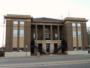
Coosa County Courthouse in Rockford
|
||
|
||

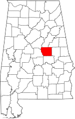
Location within the U.S. state of Alabama
|
||
 Alabama's location within the U.S. |
||
| Country | ||
| State | ||
| Founded | December 18, 1832 | |
| Seat | Rockford | |
| Largest city | Goodwater | |
| Area | ||
| • Total | 666 sq mi (1,720 km2) | |
| • Land | 651 sq mi (1,690 km2) | |
| • Water | 15 sq mi (40 km2) 2.3% | |
| Population
(2020)
|
||
| • Total | 10,387 | |
| • Estimate
(2023)
|
10,268 |
|
| • Density | 15.596/sq mi (6.022/km2) | |
| Time zone | UTC−6 (Central) | |
| • Summer (DST) | UTC−5 (CDT) | |
| Congressional district | 3rd | |
|
||
Coosa County is a county in the middle-eastern part of Alabama, a state in the United States. In 2020, about 10,387 people lived there. The main town and county seat is Rockford. The county got its name from a town of the Creek Native American tribe and the Coosa River. This river also forms one of the county's edges.
Coosa County is part of the Talladega-Sylacauga area. This area is also included in the larger Birmingham-Hoover-Talladega region.
Contents
History of Coosa County
Coosa County was created on December 18, 1832. It was formed from parts of Montgomery and Shelby counties. In 1837, it gained a small piece of land from Montgomery County. Later, in 1866, it lost some land to the south when Elmore County was formed.
Geography and Nature
Coosa County covers a total area of 666 square miles (1,725 square kilometers). Most of this area, 651 square miles (1,686 square kilometers), is land. The remaining 15 square miles (39 square kilometers) is water, which is about 2.3% of the total area. The county is located in the Piedmont region of Alabama. This area is known for its rolling hills and forests.
Main Roads in Coosa County
Several important highways pass through Coosa County:
 U.S. Highway 231
 U.S. Highway 280
 Alabama State Route 9
 Alabama State Route 22
 Alabama State Route 115
 Alabama State Route 259
Neighboring Counties
Coosa County shares its borders with six other counties:
- Talladega County (to the north)
- Clay County (to the northeast)
- Tallapoosa County (to the east)
- Elmore County (to the south)
- Chilton County (to the west)
- Shelby County (to the northwest)
People of Coosa County (Demographics)
| Historical population | |||
|---|---|---|---|
| Census | Pop. | %± | |
| 1840 | 6,995 | — | |
| 1850 | 14,543 | 107.9% | |
| 1860 | 19,273 | 32.5% | |
| 1870 | 11,945 | −38.0% | |
| 1880 | 15,113 | 26.5% | |
| 1890 | 15,906 | 5.2% | |
| 1900 | 16,144 | 1.5% | |
| 1910 | 16,634 | 3.0% | |
| 1920 | 14,839 | −10.8% | |
| 1930 | 12,460 | −16.0% | |
| 1940 | 13,460 | 8.0% | |
| 1950 | 11,766 | −12.6% | |
| 1960 | 10,726 | −8.8% | |
| 1970 | 10,662 | −0.6% | |
| 1980 | 11,377 | 6.7% | |
| 1990 | 11,063 | −2.8% | |
| 2000 | 12,202 | 10.3% | |
| 2010 | 11,539 | −5.4% | |
| 2020 | 10,387 | −10.0% | |
| 2022 (est.) | 10,268 | −11.0% | |
| U.S. Decennial Census 1790–1960 1900–1990 1990–2000 2010–2020 |
|||
The population of Coosa County has changed over the years. In 2020, the county had 10,387 residents. There were 4,032 households and 2,657 families living in the county at that time.
Population Details from 2020
In 2020, the people living in Coosa County were mostly:
- About 65.5% White (not Hispanic or Latino)
- About 28.9% Black or African American (not Hispanic or Latino)
- About 0.2% Native American
- About 0.1% Asian
- About 2.9% people of two or more races
- About 1.9% were Hispanic or Latino (who can be of any race)
Population Details from 2010
In 2010, there were 11,539 people living in Coosa County. The population density was about 18 people per square mile.
- About 66.3% of the people were White.
- About 31.0% were Black or African American.
- About 2.0% of the population was Hispanic or Latino.
There were 4,794 households in 2010. About 23% of these households had children under 18 living with them. The average household had 2.38 people. The average family had 2.89 people.
The median age in the county was 44.2 years. This means half the people were younger than 44.2 and half were older.
- About 20.5% of the population was under 18 years old.
- About 17.1% of the population was 65 years or older.
The median income for a household in the county was about $35,560. For families, the median income was about $47,451. About 16% of the total population lived below the poverty line. This included about 20.6% of those under 18.
Communities in Coosa County
Coosa County has several towns and communities.
Towns
Census-Designated Places
These are areas that are like towns but are not officially incorporated as cities or towns.
- Equality
- Hanover
- Hissop
- Mount Olive
- Nixburg
- Ray
- Stewartville
- Weogufka
Unincorporated Communities
These are smaller communities that are not officially part of any town or city.
See also
 In Spanish: Condado de Coosa para niños
 | Janet Taylor Pickett |
 | Synthia Saint James |
 | Howardena Pindell |
 | Faith Ringgold |

