
Shelby County, Alabama facts for kids
Quick facts for kids
Shelby County
|
||
|---|---|---|

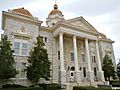
Shelby County Courthouse in Columbiana
|
||
|
||

Location within the U.S. state of Alabama
|
||
 Alabama's location within the U.S. |
||
| Country | ||
| State | ||
| Founded | February 7, 1818 | |
| Named for | Isaac Shelby | |
| Seat | Columbiana | |
| Largest city | Alabaster | |
| Area | ||
| • Total | 810 sq mi (2,100 km2) | |
| • Land | 785 sq mi (2,030 km2) | |
| • Water | 25 sq mi (60 km2) 3.0% | |
| Population
(2020)
|
||
| • Total | 223,024 | |
| • Estimate
(2023)
|
233,000 |
|
| • Density | 275.3/sq mi (106.3/km2) | |
| Time zone | UTC−6 (Central) | |
| • Summer (DST) | UTC−5 (CDT) | |
| Congressional district | 6th | |
|
||

Shelby County is a county in the central part of Alabama. In 2020, about 223,024 people lived here. This makes it the sixth-biggest county in Alabama by population. The main town, or county seat, is Columbiana. The biggest city in Shelby County is Alabaster. The county is named after Isaac Shelby. He was a famous Governor of Kentucky a long time ago. Shelby County is also part of the larger Birmingham-Hoover area.
Contents
History of Shelby County
Shelby County was started on February 7, 1818. It was named after Isaac Shelby. He was a hero from the American Revolutionary War. He was also the first governor of Kentucky.
Early Settlements and Courthouses
The first county seat was in a place called Shelbyville in 1820. This old town is now part of Pelham. The very first courthouse was made of logs. In 1826, the county seat moved to Columbia. This town is now known as Columbiana. A new brick courthouse was finished in 1854. Today, this building is called the Old Shelby County Courthouse. It is now a museum and an archive. The current courthouse was built between 1905 and 1906. It cost about $300,000 to build.
Farming and Transportation Growth
Shelby County has a long history of agriculture or farming. Since about 1990, soybeans have become a very important crop. They are now grown more than cotton here.
The Coosa River was an early inland waterway in Shelby County. This means boats could travel on it. The county also had an early east-west railroad. This railroad connected Atlanta, Georgia, to places further west. Another early railroad, the Louisville and Nashville Railroad, crossed Shelby County from north to south. It connected cities like Louisville, Nashville, and Birmingham.
Later, cars and trucks became popular. U.S. Highway 31 was built. It followed the same path as the Louisville and Nashville Railroad. Other major roads like U.S. Highway 231 and U.S. 280 also crossed the eastern part of the county.
Even later, Interstate Highway 65 was built through Shelby County. All these modern roads helped Shelby County grow a lot. Interstate 65 and U.S. Highway 31 connect Shelby County to Jefferson County to the north. This led to many towns growing into suburbs. These towns include Pelham, Helena, Alabaster, and Chelsea.
Geography of Shelby County
Shelby County covers about 810 square miles. About 785 square miles are land. The other 25 square miles are water.
Mountains, Farms, and Rivers
Some parts of Shelby County have mountains. These are the southern parts of the Appalachian Mountains. Examples include Oak Mountain and Double Oak Mountain. But many parts of Shelby County are flat. This flat land is great for farms and pastures.
The county also has lowlands along two rivers. There is also a large man-made reservoir called Lay Lake. This lake also touches Coosa, Talladega, and Chilton counties.
Most of Shelby County's water drains into the Cahaba River or the Coosa River. The Cahaba River flows along the northern edge of the county. The Coosa River valley is in the eastern part. Both are important rivers in Alabama. Further south, these rivers flow into the Alabama River. From there, the water goes to the Gulf of Mexico.
Neighboring Counties
Shelby County shares borders with these other counties:
- St. Clair County (to the northeast)
- Talladega County (to the east)
- Coosa County (to the southeast)
- Chilton County (to the south)
- Bibb County (to the southwest)
- Jefferson County (to the northwest)
Population and People
| Historical population | |||
|---|---|---|---|
| Census | Pop. | %± | |
| 1820 | 2,416 | — | |
| 1830 | 5,704 | 136.1% | |
| 1840 | 6,112 | 7.2% | |
| 1850 | 9,536 | 56.0% | |
| 1860 | 12,618 | 32.3% | |
| 1870 | 12,218 | −3.2% | |
| 1880 | 17,236 | 41.1% | |
| 1890 | 20,886 | 21.2% | |
| 1900 | 23,684 | 13.4% | |
| 1910 | 26,949 | 13.8% | |
| 1920 | 27,097 | 0.5% | |
| 1930 | 27,576 | 1.8% | |
| 1940 | 28,962 | 5.0% | |
| 1950 | 30,362 | 4.8% | |
| 1960 | 32,132 | 5.8% | |
| 1970 | 38,037 | 18.4% | |
| 1980 | 66,298 | 74.3% | |
| 1990 | 99,358 | 49.9% | |
| 2000 | 143,293 | 44.2% | |
| 2010 | 195,085 | 36.1% | |
| 2020 | 223,024 | 14.3% | |
| 2023 (est.) | 233,000 | 19.4% | |
| U.S. Decennial Census 1790–1960 1900–1990 1990–2000 2010–2020 |
|||
How Many People Live Here?
In 2020, the census counted 223,024 people in Shelby County. There were 84,241 households, which are groups of people living together. About 60,985 of these were families. The county had about 284 people per square mile. There were also 89,060 housing units, like houses and apartments.
People from Different Backgrounds
| Race / Ethnicity (NH = Non-Hispanic) | Pop 2000 | Pop 2010 | Pop 2020 | % 2000 | % 2010 | % 2020 |
|---|---|---|---|---|---|---|
| White alone (NH) | 126,951 | 156,371 | 162,712 | 88.60% | 80.16% | 72.96% |
| Black or African American alone (NH) | 10,570 | 20,606 | 28,711 | 7.38% | 10.56% | 12.87% |
| Native American or Alaska Native alone (NH) | 441 | 458 | 478 | 0.31% | 0.23% | 0.21% |
| Asian alone (NH) | 1,465 | 3,699 | 5,114 | 1.02% | 1.90% | 2.29% |
| Pacific Islander alone (NH) | 21 | 62 | 91 | 0.01% | 0.03% | 0.04% |
| Other race alone (NH) | 51 | 250 | 798 | 0.04% | 0.13% | 0.36% |
| Mixed race or Multiracial (NH) | 884 | 2,072 | 8,660 | 0.62% | 1.06% | 3.88% |
| Hispanic or Latino (any race) | 2,910 | 11,567 | 16,460 | 2.03% | 5.93% | 7.38% |
| Total | 143,293 | 195,085 | 223,024 | 100.00% | 100.00% | 100.00% |
The 2010 census showed that about 83% of people were White. About 10.6% were Black or African American. About 1.9% were Asian. People of Hispanic or Latino background made up about 5.9% of the population.
Many people in Shelby County have ancestors from different places. The largest groups reported were:
- English – 15.8%
- Irish – 13.9%
- German – 11.1%
- American – 11.0%
- African American - 10.6%
Households and Age
In 2010, about 34.3% of households had children under 18 living there. About 59.7% were married couples. The average household had 2.60 people. The average family had 3.08 people.
About 25.6% of the people were under 18 years old. About 10.6% were 65 or older. The average age was 36.9 years.
The median household income was $68,380. This means half of households earned more, and half earned less. The median family income was $81,406. About 7.4% of all people lived below the poverty line.
Education in Shelby County
Shelby County Schools runs most of the public schools. The city of Alabaster has its own school system. It runs six public schools. In 2014, Pelham started its own school system. It took over three schools from Shelby County. These included Pelham High School. A new school, Pelham Ridge Elementary, opened in 2016.
Transportation in Shelby County
Shelby County has many ways to get around.
Major Roads
 Interstate 65
 U.S. Highway 31
 U.S. Highway 231
 U.S. Highway 280
 State Road 25
 State Road 70
 State Road 76
 State Road 119
 State Road 145
 State Road 155
 State Road 261
Railroads
Trains also move goods and people through the county.
- CSX Transportation
- Norfolk Southern Railway
- Calera & Shelby Railroad
Airports
For air travel, there is the Shelby County Airport. It is used for smaller planes. For bigger planes and commercial flights, people use Birmingham-Shuttlesworth International Airport. This airport is in the next county over, Jefferson County.
Communities in Shelby County
Shelby County has many different towns and cities.
Cities
- Alabaster
- Birmingham (mostly in Jefferson County)
- Calera (partly in Chilton County)
- Chelsea
- Columbiana (county seat)
- Helena (partly in Jefferson County)
- Hoover (mostly in Jefferson County)
- Leeds (partly in Jefferson County and St. Clair County)
- Montevallo
- Pelham
- Vestavia Hills (partly in Jefferson County)
- Vincent (partly in St. Clair County and Talladega County)
- Westover
Towns
Census-Designated Places
These are areas that are like towns but are not officially incorporated.
Unincorporated Communities
These are smaller communities that are not part of any city or town.
Fun Places to Visit
Shelby County has many interesting places to explore:
- Aldrich Coal Mine Museum
- American Village
- Cahaba River Wildlife Management Area
- Colonial Promenade Alabaster (a shopping center)
- Heart of Dixie Railroad Museum
- Indian Springs School
- Oak Mountain Amphitheatre (for concerts)
- Oak Mountain State Park (for outdoor fun)
- Old Shelby County Courthouse and Museum
- Shelby Iron Works Park
Images for kids
-
Shelby County Courthouse in Columbiana
See also
 In Spanish: Condado de Shelby (Alabama) para niños
