Leeds, Alabama facts for kids
Quick facts for kids
Leeds, Alabama
|
||
|---|---|---|
|
||
| Nickname(s):
City of Valor
|
||

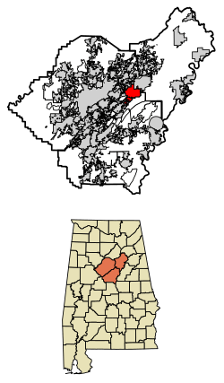
Location of Leeds in Jefferson County and Shelby County and St. Clair County, Alabama.
|
||
| Country | United States | |
| State | Alabama | |
| Counties | Jefferson, St. Clair, Shelby | |
| Area | ||
| • Total | 22.99 sq mi (59.55 km2) | |
| • Land | 22.76 sq mi (58.95 km2) | |
| • Water | 0.23 sq mi (0.60 km2) | |
| Elevation | 673 ft (205 m) | |
| Population
(2020)
|
||
| • Total | 12,324 | |
| • Density | 541.48/sq mi (209.07/km2) | |
| Time zone | UTC-6 (Central (CST)) | |
| • Summer (DST) | UTC-5 (CDT) | |
| ZIP Code |
35094
|
|
| Area code(s) | 205 & 659 | |
| FIPS code | 01-41968 | |
| GNIS feature ID | 2404905 | |
Leeds is a city in Alabama, USA. It is special because it is located in three different counties: Jefferson, St. Clair, and Shelby. Leeds is an eastern suburb of Birmingham. In 2020, about 12,324 people lived there.
The city was started in 1877. It was built for the workers and their families from a Portland cement factory called Lehigh.
Leeds is known as "The City of Valor." This is because three brave people from Leeds received the Congressional Medal of Honor. These heroes were Alford L. McLaughlin, William Lawley, and Henry "Red" Erwin. They served in World War II and the Korean War. There is a special wall at the Leeds Historical Society's museum that honors them. In 2023, the Leeds High School band director, Chip Wise, wrote a song called City of Valor for these heroes. His band was even invited to play it at the Pearl Harbor National Memorial in 2024!
Contents
History of Leeds, Alabama
The history of Leeds was shaped by events like the War of 1812, its geography, and different cultures. Leeds is located where old Native American paths crossed. This area attracted early European settlers and their African-American slaves. They came for the good farming land and rich sources of coal and minerals.
Early settlers built churches and schools. Many of these still stand in areas like Cedar Grove and Oak Ridge. Leeds officially became a city on April 27, 1887. It has always been near the Little Cahaba River, an old stagecoach route, and two major railroads.
One of the first settlers was James Hamilton, a veteran of the War of 1812. He settled in Cedar Grove in 1816. Another important person was John Richard Ingram Pashal Stewart, a Cherokee teacher and War of 1812 veteran, who settled at Ohanafeefee Village around 1840. In 1820, settlers formed the Shiloh Cumberland Presbyterian Church, one of the first churches in middle Alabama. By 1887, African-American settlers also came to Leeds to work at the cement plant and on the railroads. Some of them helped start Scott City and the Leeds Negro/Primary School in 1921.
The Legend of John Henry
Many people believe the famous folk story of John Henry started in Leeds. In this story, John Henry, a strong "steel-drivin' man," races against a steam engine. He wins by laying railroad tracks through the Oak Mountain Tunnel in Leeds.
A retired chemistry professor, John Garst, thinks this race happened on September 20, 1887. He believes it took place at the Coosa Mountain Tunnel or the Oak Mountain Tunnel. John Henry might have been a man named Henry, born in 1850. Since 2007, Leeds has celebrated this legend with an annual festival. It is called the Leeds Downtown Folk Festival and John Henry Celebration.
Geography and Location
Leeds is mostly in Jefferson County. It is located at 33°32′44″N 86°33′27″W / 33.54556°N 86.55750°W.
The city covers about 22.5 square miles (58.3 square kilometers). Only a small part of this area, about 0.2 square miles (0.5 square kilometers), is water.
Leeds is east of Birmingham, along Interstate 20. You can get to Leeds from exits 140 and 144 on I-20. Downtown Birmingham is about 18 miles (29 km) west. Atlanta is about 129 miles (208 km) east. U.S. Route 411 also starts in Leeds.
Population and People
| Historical population | |||
|---|---|---|---|
| Census | Pop. | %± | |
| 1890 | 250 | — | |
| 1910 | 810 | — | |
| 1920 | 1,600 | 97.5% | |
| 1930 | 2,529 | 58.1% | |
| 1940 | 2,910 | 15.1% | |
| 1950 | 3,306 | 13.6% | |
| 1960 | 6,162 | 86.4% | |
| 1970 | 6,991 | 13.5% | |
| 1980 | 8,638 | 23.6% | |
| 1990 | 9,946 | 15.1% | |
| 2000 | 10,455 | 5.1% | |
| 2010 | 11,773 | 12.6% | |
| 2020 | 12,324 | 4.7% | |
| U.S. Decennial Census | |||
Leeds Population in 2020
In 2020, there were 12,324 people living in Leeds. There were 4,792 households and 3,388 families.
| Race | Num. | Perc. |
|---|---|---|
| White (non-Hispanic) | 8,831 | 71.66% |
| Black or African American (non-Hispanic) | 1,887 | 15.31% |
| Native American | 31 | 0.25% |
| Asian | 85 | 0.69% |
| Pacific Islander | 5 | 0.04% |
| Other/mixed | 516 | 4.19% |
| Hispanic or Latino | 969 | 7.86% |
Leeds Population in 2010
In 2010, Leeds had 11,773 people and 4,818 households. The city had about 515 people per square mile. Most of the people were White (78.7%) or African American (14.3%). About 6.6% of the population was Hispanic or Latino.
The average household had 2.48 people. About 21.9% of households had children under 18. About 14.8% of households had someone living alone who was 65 or older. The average income for a household was $44,149.
Education in Leeds
The Leeds City School District serves the city of Leeds.
In 2009, the Leeds City Board of Education started building two new schools. These were Leeds Middle School and Leeds High School. They also updated Leeds Elementary School. This included a bigger office and a new awning.
In 2016, Leeds Primary School was built. It houses students from pre-kindergarten through second grade. This helped reduce crowding at the elementary school. In 2024, second graders moved from the primary school to the elementary school.
Leeds High School Sports Achievements
Leeds High School has a strong sports program. Their football team, the Greenwave, has won several state championships:
- Class 3A AHSAA state football championship in 2008 (finished 15–0).
- Class 3A AHSAA state football championship in 2010 (finished 15–0).
- Class 4A AHSAA state football championship in 2014 (finished 14–1).
- Class 4A AHSAA state football championship in 2015 (finished 14–1).
The Greenwave basketball team won the 3A AHSAA state basketball championship in 2009. The wrestling team won the Class 1A-5A AHSAA state wrestling championship in 2015. The track and field team has also won many state championships. In 2007, the softball team won the 3A state championship.
The Leeds High School "Pride of the Greenwave" Marching Band is also excellent. In 2023, they received top ratings at the Pinson Valley Pride of the Valley Marching Contest. They won "Best in Class" for their Drum Line and Band.
Famous People from Leeds
Many notable people have come from Leeds, Alabama:
- Rebecca Bace – A computer security expert.
- Charles Barkley – A famous basketball player in the Basketball Hall of Fame.
- Chandler Champion – She was Miss Alabama in 2013.
- Henry E. Erwin – A Medal of Honor recipient from World War II.
- Kenneth L. Farmer, Jr. – A retired U.S. Army major general.
- Nathan Glick – A talented artist and illustrator.
- Caitlín R. Kiernan – An author and paleontologist.
- William R. Lawley, Jr. – A Medal of Honor recipient from World War II.
- Harry Lee – A former Canadian Football League player.
- Mark Martin – A well-known cartoonist.
- Alford L. McLaughlin – A Medal of Honor recipient from the Korean War.
- Sam Star – An American drag performer.
- Harry Walker – A Major League Baseball player and manager.
- Dixie Walker (pitcher) – A Major League Baseball player.
See also
 In Spanish: Leeds (Alabama) para niños
 | James Van Der Zee |
 | Alma Thomas |
 | Ellis Wilson |
 | Margaret Taylor-Burroughs |


