St. Clair County, Alabama facts for kids
Quick facts for kids
St. Clair County
|
|||
|---|---|---|---|

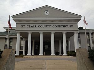
St. Clair County Courthouse in Pell City
|
|||
|
|||

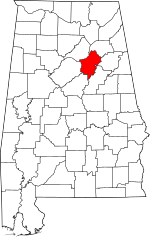
Location within the U.S. state of Alabama
|
|||
 Alabama's location within the U.S. |
|||
| Country | |||
| State | |||
| Founded | November 20, 1818 | ||
| Named for | Arthur St. Clair | ||
| Seat | Ashville & Pell City | ||
| Largest city | Moody | ||
| Area | |||
| • Total | 654 sq mi (1,690 km2) | ||
| • Land | 632 sq mi (1,640 km2) | ||
| • Water | 22 sq mi (60 km2) 3.3% | ||
| Population
(2020)
|
|||
| • Total | 91,103 | ||
| • Estimate
(2023)
|
95,552 |
||
| • Density | 139.30/sq mi (53.78/km2) | ||
| Time zone | UTC−6 (Central) | ||
| • Summer (DST) | UTC−5 (CDT) | ||
| Congressional district | 3rd | ||
|
|||
St. Clair County is a county in the central part of Alabama. In 2020, about 91,103 people lived here. It is special because it has two county seats: Ashville and Pell City. A county seat is like the main town where the county government offices are. St. Clair County is one of only two counties in Alabama with two county seats.
The county is named after General Arthur St. Clair. He was an important officer in the French and Indian War. St. Clair County is also part of the larger Birmingham metropolitan area.
Contents
Discovering St. Clair County's Past
St. Clair County was created on November 20, 1818. This happened when the Alabama Territory government decided to split off an area from Shelby County. The first county seat, Ashville, was named after John Ash.
Over the years, parts of St. Clair County were used to create other counties. In 1836, Cherokee County and DeKalb County were formed. After the Civil War, in 1866, a section was used to create Etowah County.
Why Two County Seats?
St. Clair County has a unique feature: two county seats. This happened because of the county's geography. The Appalachian Mountains run through the county, making it hard to travel and manage things from one side to the other. To make it easier for people to access government services, a second county seat was set up in Pell City. This helped serve the southeast side of the county better.
In 2019, St. Clair County made history by adopting its own flag. It was the seventh county in Alabama to do so.
Exploring St. Clair County's Geography
St. Clair County covers a total area of about 654 square miles. Most of this area, 632 square miles, is land. The remaining 22 square miles, which is about 3.3%, is water.
Neighboring Counties
St. Clair County shares its borders with several other counties:
- Etowah County to the northeast
- Calhoun County to the east
- Talladega County to the southeast
- Shelby County to the southwest
- Jefferson County to the west
- Blount County to the northwest
Understanding St. Clair County's Population
The population of St. Clair County has grown a lot over the years.
| Historical population | |||
|---|---|---|---|
| Census | Pop. | %± | |
| 1820 | 4,166 | — | |
| 1830 | 5,975 | 43.4% | |
| 1840 | 5,638 | −5.6% | |
| 1850 | 6,829 | 21.1% | |
| 1860 | 11,013 | 61.3% | |
| 1870 | 9,360 | −15.0% | |
| 1880 | 14,462 | 54.5% | |
| 1890 | 17,353 | 20.0% | |
| 1900 | 19,425 | 11.9% | |
| 1910 | 20,715 | 6.6% | |
| 1920 | 23,383 | 12.9% | |
| 1930 | 24,510 | 4.8% | |
| 1940 | 27,336 | 11.5% | |
| 1950 | 26,687 | −2.4% | |
| 1960 | 25,388 | −4.9% | |
| 1970 | 27,956 | 10.1% | |
| 1980 | 41,205 | 47.4% | |
| 1990 | 50,009 | 21.4% | |
| 2000 | 64,742 | 29.5% | |
| 2010 | 83,593 | 29.1% | |
| 2020 | 91,103 | 9.0% | |
| 2023 (est.) | 95,552 | 14.3% | |
| U.S. Decennial Census 1790–1960 1900–1990 1990–2000 2010–2020 |
|||
Population in 2020
In 2020, the county had 91,103 people living in 32,829 households. About 25,409 of these were families.
Population in 2010
In 2010, there were 83,593 people. The county had about 132 people per square mile.
- About 23.7% of the people were under 18 years old.
- About 13.1% were 65 years or older.
- The average age was 38.6 years.
The average income for a household was $48,837. For families, it was $56,107.
Fun Places to Visit in St. Clair County
St. Clair County offers some cool spots for visitors:
- Logan Martin Lake: A large lake popular for boating, fishing, and other water activities.
- Horse Pens 40: A private outdoor park located on top of Chandler Mountain. It's known for its unique rock formations and is a popular spot for climbing and outdoor adventures.
Communities in St. Clair County
St. Clair County is home to several cities, towns, and smaller communities.
Cities
- Ashville (one of the county seats)
- Leeds (mostly in Jefferson County and Shelby County)
- Margaret
- Moody
- Pell City (one of the county seats)
- Springville
- Trussville (mostly in Jefferson County)
Towns
- Argo (partly in Jefferson County)
- Odenville
- Ragland
- Riverside
- Steele
- Vincent (partly in Shelby County and Talladega County)
Unincorporated Communities
These are smaller communities that are not officially cities or towns.
- Acmar
- Cooks Springs
- Cropwell
- New London
- Pinedale Shores
- Prescott
- St. Clair Springs
- Wattsville
- Whitney
Former Towns
- Branchville (now a neighborhood in Odenville)
Getting Around St. Clair County
The county has several important roads and railways that help people and goods move around.
Major Highways
 Interstate 20
 Interstate 59
 U.S. Route 11
 U.S. Route 78
 U.S. Route 231
 U.S. Route 411
 State Route 23
 State Route 34
 State Route 144
 State Route 174
Railways
- Alabama and Tennessee River Railway
- Norfolk Southern Railway
In the past, passenger trains like the Kansas City-Florida Special used to stop in Pell City. The last passenger trains stopped here in 1967. Today, if you want to catch a passenger train, the closest one is Amtrak's Crescent in Anniston, which is about 30.6 miles away.
See also
 In Spanish: Condado de St. Clair (Alabama) para niños
 | Selma Burke |
 | Pauline Powell Burns |
 | Frederick J. Brown |
 | Robert Blackburn |


