DeKalb County, Alabama facts for kids
Quick facts for kids
DeKalb County
|
||
|---|---|---|

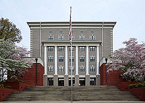
DeKalb County Courthouse in Fort Payne
|
||
|
||

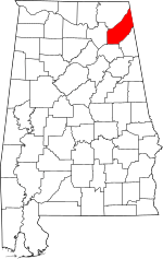
Location within the U.S. state of Alabama
|
||
 Alabama's location within the U.S. |
||
| Country | ||
| State | ||
| Founded | January 9, 1836 | |
| Named for | Johann de Kalb | |
| Seat | Fort Payne | |
| Largest city | Fort Payne | |
| Area | ||
| • Total | 779 sq mi (2,020 km2) | |
| • Land | 777 sq mi (2,010 km2) | |
| • Water | 1.6 sq mi (4 km2) 0.2% | |
| Population
(2020)
|
||
| • Total | 71,608 | |
| • Estimate
(2023)
|
72,569 |
|
| • Density | 91.92/sq mi (35.492/km2) | |
| Time zone | UTC−6 (Central) | |
| • Summer (DST) | UTC−5 (CDT) | |
| Congressional district | 4th | |
|
||
DeKalb County is a county located in the northeastern part of Alabama, a state in the United States. In 2020, about 71,608 people lived here. The main town and county seat is Fort Payne. The county was named after Major General Baron Johann de Kalb, a brave hero from the American Revolution. DeKalb County is also part of a larger area called the Huntsville-Decatur-Albertville, AL Combined Statistical Area.
Contents
History of DeKalb County
DeKalb County was officially created by the Alabama government on January 9, 1836. This land was given to the U.S. government by the Cherokee Nation, a group of Native American people. The county was named to honor Major General Baron Johann de Kalb, who fought bravely during the American Revolution.
DeKalb County was once home to the famous Cherokee leader, Sequoyah. He was known for creating the Cherokee writing system.
Major Natural Events
DeKalb County has experienced some significant natural events. On April 29, 2003, an earthquake with a strength of 4.6 happened near the county's eastern edge. This earthquake caused power outages, cracked foundations, and even made a chimney fall. People felt it across many southeastern states, including Alabama, Georgia, and Tennessee.
The county also faced a very strong tornado system on April 27, 2011, known as the 2011 Super Outbreak. This event caused a lot of damage and sadly, 31 people in the county lost their lives. Twenty-five of these deaths were from the 2011 Rainsville tornado, which was one of the strongest tornadoes of that outbreak.
Geography of DeKalb County
According to the U.S. Census Bureau, DeKalb County covers a total area of 779 square miles. Most of this area, about 777 square miles, is land. Only a small part, about 1.6 square miles, is water.
Neighboring Counties
DeKalb County shares borders with several other counties:
- Jackson County to the north
- Dade County, Georgia to the northeast
- Walker County, Georgia to the east
- Chattooga County, Georgia to the east
- Cherokee County to the southeast
- Etowah County to the south
- Marshall County to the west
Protected Natural Areas
Part of the Little River Canyon National Preserve is located within DeKalb County. This preserve protects a beautiful canyon and river.
People of DeKalb County
| Historical population | |||
|---|---|---|---|
| Census | Pop. | %± | |
| 1840 | 5,929 | — | |
| 1850 | 8,245 | 39.1% | |
| 1860 | 10,705 | 29.8% | |
| 1870 | 7,126 | −33.4% | |
| 1880 | 12,675 | 77.9% | |
| 1890 | 21,106 | 66.5% | |
| 1900 | 23,558 | 11.6% | |
| 1910 | 28,261 | 20.0% | |
| 1920 | 34,426 | 21.8% | |
| 1930 | 40,104 | 16.5% | |
| 1940 | 43,075 | 7.4% | |
| 1950 | 45,048 | 4.6% | |
| 1960 | 41,417 | −8.1% | |
| 1970 | 41,981 | 1.4% | |
| 1980 | 53,658 | 27.8% | |
| 1990 | 54,651 | 1.9% | |
| 2000 | 64,452 | 17.9% | |
| 2010 | 71,109 | 10.3% | |
| 2020 | 71,608 | 0.7% | |
| 2023 (est.) | 72,569 | 2.1% | |
| U.S. Decennial Census 1790–1960 1900–1990 1990–2000 2010–2020 |
|||
Population in 2020
In 2020, the census showed that 71,608 people lived in DeKalb County. There were 24,880 households and 16,366 families.
| Race | Number of People | Percentage |
|---|---|---|
| White (not Hispanic) | 54,529 | 76.15% |
| Black or African American (not Hispanic) | 1,019 | 1.42% |
| Native American | 715 | 1.0% |
| Asian | 237 | 0.33% |
| Pacific Islander | 16 | 0.02% |
| Other/Mixed | 3,348 | 4.68% |
| Hispanic or Latino | 11,744 | 16.4% |
Transportation in DeKalb County
DeKalb County has several important roads and a railway line that help people and goods move around.
Main Highways
 Interstate 59
 U.S. Route 11
 State Route 35
 State Route 40
 State Route 68
 State Route 75
 State Route 117
 State Route 176
 State Route 227
Railways
- Norfolk Southern Railway
Communities in DeKalb County
DeKalb County is home to several cities, towns, and smaller communities.
Cities
- Fort Payne (This is the county seat, where the main government offices are)
- Henagar
- Rainsville
Towns
- Collinsville (partly in Cherokee County)
- Crossville
- Fyffe
- Geraldine
- Hammondville
- Ider
- Lakeview
- Mentone
- Pine Ridge
- Powell
- Sand Rock (partly in Cherokee County)
- Shiloh
- Sylvania
- Valley Head
Unincorporated Communities
These are smaller communities that are not officially organized as cities or towns.
Ghost Towns
These are places where people used to live, but now they are mostly empty or abandoned.
See also
 In Spanish: Condado de DeKalb (Alabama) para niños
 | James Van Der Zee |
 | Alma Thomas |
 | Ellis Wilson |
 | Margaret Taylor-Burroughs |


