
Fort Payne, Alabama facts for kids
Quick facts for kids
Fort Payne
|
|||
|---|---|---|---|

Gault Avenue in downtown Fort Payne
|
|||
|
|||
| Nickname(s):
Official Sock Capital of the World
|
|||

Location of Fort Payne in DeKalb County, Alabama.
|
|||
| Country | United States | ||
| State | Alabama | ||
| County | DeKalb | ||
| Government | |||
| • Type | Mayor-Council (5 members) | ||
| Area | |||
| • Total | 56.76 sq mi (147.01 km2) | ||
| • Land | 56.41 sq mi (146.09 km2) | ||
| • Water | 0.35 sq mi (0.92 km2) | ||
| Elevation | 1,079 ft (329 m) | ||
| Population
(2020)
|
|||
| • Total | 14,877 | ||
| • Density | 263.75/sq mi (101.83/km2) | ||
| Time zone | UTC-6 (Central (CST)) | ||
| • Summer (DST) | UTC-5 (CDT) | ||
| ZIP code |
35967-35968
|
||
| Area code(s) | 256 | ||
| FIPS code | 01-27616 | ||
| GNIS feature ID | 2403645 | ||


Fort Payne is a city in DeKalb County, located in northeastern Alabama, United States. It is the main city of the county and is close to Lookout Mountain. In 2020, about 14,877 people lived there.
The city grew around a fort built in the 1830s. This fort was used to hold members of the Cherokee tribe. They were gathered by the military before being forced to move to Indian Territory in 1838. This difficult journey is known as the Trail of Tears.
Over time, European-American settlers built a community around the old fort. The city grew quickly in the late 1800s because of its natural resources. Manufacturing became very important in the early 1900s. Fort Payne was once known as the "Sock Capital of the World."
Contents
History of Fort Payne
In the late 1700s and early 1800s, this area was home to Willstown. This was an important town for the Lower Cherokee people. They had moved south into what is now Alabama to avoid pressure from European-American settlers.
For a while, Sequoyah lived here. He was a silversmith who created the syllabary for the Cherokee language by 1821. This was one of the few writing systems made by one person from a culture that didn't have a written language before. After this, the Cherokee people in Alabama started publishing their first newspaper, The Cherokee Phoenix, in both Cherokee and English.
The settlement was often called Willstown after its leader, Will Weber. He had red hair and was the son of Cherokee and German parents, but he was raised as Cherokee.
In the 1830s, before the forced removal of Native Americans, the U.S. Army built a fort near Willstown. This fort was commanded by Major John Payne. Its purpose was to hold Cherokee people from Alabama before they were forced to move to Indian Territory (which is now Oklahoma). This sad event is known as the Trail of Tears. Today, only a chimney from Fort Payne remains in the city's downtown area.
How Fort Payne Grew (1800s-1900s)
Even though European Americans wanted the land for farming, Fort Payne and the surrounding area were not very populated by the 1860s. During the American Civil War, only small fights happened here. There were no major targets nearby. A large Union army briefly entered the county around the time of the Second Battle of Chattanooga, but they did not fight any big Confederate forces.
In 1878, Fort Payne was chosen as the county seat, which is the main town for the county government. In 1889, it officially became a town. Before this, the community of Lebanon had been the county seat since 1850. Fort Payne's growth really took off when railroad lines were completed. These lines connected Birmingham and Chattanooga and passed right through Fort Payne. People in the county wanted the county seat to be on a railroad line, as it was seen as important for the future.
In the late 1880s, Fort Payne grew even more after coal and iron were discovered. These resources were important for industries. Many investors and workers from New England and the North came to the area for new jobs. This time was called the "Boom Days" or simply the "Boom."
Many important historic buildings in Fort Payne were built during this time of economic growth. These include the state's oldest standing theater, the Fort Payne Opera House. Another is the old factory of the Hardware Manufacturing Company, which is now the Fort Payne Depot Museum. This building used to be a train station for the Norfolk Southern Railway. After fewer people traveled by train in the mid-1900s, the depot became a museum about local history.
The amounts of iron and coal found were much smaller than people expected. Many of the business promoters left the area for Birmingham, Alabama, which became the state's biggest industrial city. Fort Payne then went through a period of economic slowdown.
In 1907, the W.B. Davis Hosiery Mill started making socks and hosiery from local cotton. Making hosiery became the most important industry in Fort Payne. By the early 2000s, the hosiery industry in Fort Payne employed over 7,000 people in more than 100 factories. It produced more than half of the socks made in the United States and was known as the "Sock Capital of the World."
Changes in the Sock Industry
Starting in the 1990s, trade agreements like the North American Free Trade Agreement (NAFTA) made it cheaper to import textile products into the United States. This led to a big increase in sock imports. By the early 2000s, a very large and efficient center for sock production grew in Datang, Zhuji in Zhejiang Province, China. Raw materials and sock-making machines were also made in Datang. If a company in Fort Payne needed a replacement part for a sock machine, they might wait two months for it to arrive from Italy. But a manufacturer in Datang could get the part from a local company in just half an hour.
Large American retail companies started buying socks from Datang. These companies pushed for very low prices, meaning Datang producers sometimes made only a 3% profit. As American companies bought more products from China, Datang became the new "Sock Capital of the World." Many businesses in Fort Payne said that foreign manufacturers, especially from China, were selling socks for less than they cost to make. This was done to force American companies out of business.
By 2005, the number of people working in sock mills in Fort Payne dropped to about 5,500, and several mills closed. In late 2005, the U.S. government reached an agreement with the Chinese government to slow down the removal of import taxes, delaying their full removal until 2008. The hosiery industry still exists in Fort Payne. It has changed to make different kinds of socks, like special designs from companies such as Zkano, and other specialty or medical socks.
In the 1990s, leaders in Fort Payne realized their manufacturing industry was facing global competition. They started working to bring different types of businesses to the city. Several new commercial and industrial projects were developed. One of the biggest was the construction of a distribution center for The Children's Place stores in 2006. This facility created 600 jobs in its first phase.
Other large companies in Fort Payne include Heil Environmental Industries (which makes sanitation trucks), Vulcraft (which makes steel roofing systems), and Game Time (which makes playground equipment).
Fort Payne's Geography and Climate
.jpg)
Fort Payne covers about 56.76 square miles (147.01 square kilometers). Most of this area, about 56.41 square miles (146.09 square kilometers), is land. The rest, about 0.35 square miles (0.92 square kilometers), is water.
The city center is in a narrow valley along Big Wills Creek. This area is part of the Cumberland Plateau region, just west of Lookout Mountain. Sand Mountain is a bit further to the west. The city's boundaries extend east and south, so more than half of Fort Payne is now on Lookout Mountain. Water from the area flows through Big Wills Creek into the Coosa River.
In 2003, a magnitude 4.9 earthquake happened here.
Weather in Fort Payne
Fort Payne has a subtropical climate. This means winters usually have some snow, but not very often. Cloudmont Ski Resort on Lookout Mountain can make snow when it's cold enough. The area can also experience tornadoes. The northern part of the city was hit by strong tornadoes in 1952 and 1973, causing a lot of damage. Another tornado struck the city exactly ten years later. In 1994, a tornado passed just west of the city.
Sometimes, a hurricane that hits the Gulf of Mexico can reach Fort Payne as a tropical storm. However, in 1995, the center of Hurricane Opal reached Fort Payne with hurricane-force winds. In 1993, the Storm of the Century brought more than 20 inches (50 cm) of snow to Fort Payne. This stopped the city and surrounding area for several days. The climate here is known as a "Humid Subtropical Climate."
People of Fort Payne
| Historical population | |||
|---|---|---|---|
| Census | Pop. | %± | |
| 1890 | 2,698 | — | |
| 1900 | 1,037 | −61.6% | |
| 1910 | 1,317 | 27.0% | |
| 1920 | 2,025 | 53.8% | |
| 1930 | 3,375 | 66.7% | |
| 1940 | 4,424 | 31.1% | |
| 1950 | 6,226 | 40.7% | |
| 1960 | 7,029 | 12.9% | |
| 1970 | 8,435 | 20.0% | |
| 1980 | 11,485 | 36.2% | |
| 1990 | 11,838 | 3.1% | |
| 2000 | 12,938 | 9.3% | |
| 2010 | 14,012 | 8.3% | |
| 2020 | 14,877 | 6.2% | |
| U.S. Decennial Census | |||
Population in 2020
In 2020, Fort Payne had 14,877 people living in the city. There were 5,066 households and 3,219 families.
Population in 2010
In 2010, Fort Payne had a population of 14,012 people. About 72% of the population was non-Hispanic white. About 20.9% of the population was Hispanic or Latino.
Fun Things to Do in Fort Payne


You can see the ruins of the old Fort Payne in the historic downtown area.
The National Park Service has its headquarters here for the nearby Little River Canyon National Preserve. This is a protected area of about 14,000 acres (57 square kilometers) created in 1992. The canyon is on Lookout Mountain, just outside the city.
Another natural place to visit is DeSoto State Park. It has a lodge, restaurant, cabins, and places to access the river. Manitou Cave is also close to Fort Payne.
The famous country music group Alabama is from Fort Payne. The city also has the group's fan club and museum.
Fort Payne is about a 30-minute drive from large water recreation areas. These include Guntersville Lake and Weiss Lake, which is an artificial lake on the Coosa River. Fort Payne is also near Mentone, a popular mountain resort. Mentone is known for summer camps for kids, rustic hotels, restaurants, and cabins.
Schools in Fort Payne
Fort Payne has its own school system called Fort Payne City Schools. The schools include Wills Valley Elementary (Kindergarten-2nd grade), Little Ridge Intermediate (3rd-5th grade), Fort Payne Middle School (6th-8th grade), and Fort Payne High School (9th-12th grade).
Brian Jett is the Superintendent of Education for the school system.
Media and News
- Radio stations:
- WFPA-AM 1400 (News/Talk)
- WZOB-AM 1250 (Country music)
- Newspapers:
- The Times-Journal
- The Dekalb Advertiser
- Southern Torch
Transportation and Health Care
Health Care
- DeKalb Regional Medical Center: This is a hospital with 134 beds.
Transportation
 Interstate 59
 U.S. Highway 11
 Alabama State Route 35
- Norfolk Southern Railway
 Isbell Field (the city's airport)
Famous People from Fort Payne
Many notable people have connections to Fort Payne:
- Miles C. Allgood (1878–1977), a U.S. congressman.
- Mark E. Biddle, a scholar who studies the Old Testament.
- Harry B. Brock, Jr., a banker and generous giver.
- Weston Burt, a country music singer.
- David Brown (translator), a Cherokee interpreter and missionary.
- Jeff Cook, Teddy Gentry, and Randy Owen, who started the country music band Alabama.
- Thomas H. Cook, a mystery writer.
- Lt. Gen. Duward Crow (1919–1997), a high-ranking officer in the U.S. Air Force and a leader at NASA.
- James Dean, an author and artist known for "Pete the Cat."
- Jerry Ellis, an author.
- Howard Finster, a religious folk artist and Baptist minister.
- The Flock Family, who were famous NASCAR drivers:
- Bob Flock (1918–1964)
- Fonty Flock (1921–1972)
- Tim Flock (1924–1998)
- Ethel Mobley (1920–1984)
- Milford W. Howard, a congressman and author.
- Lt. Gen. Forrest S. McCartney, a U.S. Air Force officer and director of the John F. Kennedy Space Center.
- James McKinney, a 5-string banjo player.
- Evan McPherson, an NFL player.
- Larry Nelson, a professional golfer.
- Philip Ober, an actor.
- Lilius Bratton Rainey, a congressman.
- Ron Sparks, a politician who was Alabama Commissioner of Agriculture and Industries.
- Edward Stinson, an aviator who founded the Stinson Aircraft Company.
- Katherine Stinson, a pioneer aviator and one of the first women in the U.S. to become a licensed pilot; she was Edward Stinson's sister.
Interesting Facts About Fort Payne
Starting in 1989, Fort Payne held the world record for the "Largest Cake Ever Baked." The cake weighed 128,238 pounds and was made to celebrate the city's 100th birthday.
Images for kids
-
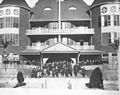
The DeKalb Hotel, built in 1889, burned in 1918.

See also
 In Spanish: Fort Payne para niños
