
Interstate 59 facts for kids
Quick facts for kids
|
|
|---|---|
| Lua error in Module:Infobox_road/map at line 15: attempt to index field 'wikibase' (a nil value). | |
| Route information | |
| Length | 445.23 mi (716.53 km) |
| Major junctions | |
| South end | |
| North end | |
| Highway system | |
| Main route of the Interstate Highway System Main • Auxiliary • Business |
|

Interstate 59, often called I-59, is a major highway in the United States. It is part of the Interstate Highway System, a big network of roads across the country. This highway stretches for about 445 miles (716 kilometers). It begins near Slidell, Louisiana, and travels northeast. Its journey ends in Wildwood, Georgia.
Contents
What is an Interstate Highway?
An Interstate Highway is a special kind of road. These roads are designed for fast and safe travel. They connect different states across the United States. The Interstate Highway System helps people and goods move easily. These highways are usually freeways, meaning they have no traffic lights or intersections. This allows for smooth, continuous driving.
Where Does I-59 Go?
Interstate 59 crosses through four different states. It starts in the southern state of Louisiana. From there, it heads north into Mississippi. After Mississippi, it continues into Alabama. Finally, it reaches its northern end in Georgia.
Cities Along the Way
I-59 passes by several important cities. In Mississippi, it goes near Hattiesburg and Meridian. These cities are important stops along the route.
When I-59 enters Alabama, it passes through Tuscaloosa. This city is home to a large university. Further north in Alabama, I-59 goes right through Birmingham. Birmingham is a big city and a major hub for travel. In Birmingham, I-59 connects with other important interstates.
Images for kids
-
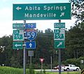
At the bottom of I-12's eastbound ramp to LA 59, travelers also find a shield for I-59, some 20 miles (32 km) farther east
-
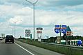
I-59 cosigned with I-20 in Mississippi
-
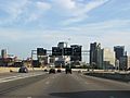
I-59/I-20 approaching I-65 in downtown Birmingham

.jpg)

See also
 In Spanish: Interestatal 59 para niños
