Henagar, Alabama facts for kids
Quick facts for kids
Henagar
|
||
|---|---|---|

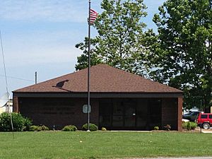
Post office in Henagar
|
||
|
||
| Motto(s):
"Building a Future, Preserving the Past"
|
||

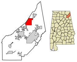
Location of Henagar in DeKalb County, Alabama.
|
||
| Country | United States | |
| State | Alabama | |
| County | DeKalb | |
| Area | ||
| • Total | 22.64 sq mi (58.64 km2) | |
| • Land | 22.61 sq mi (58.56 km2) | |
| • Water | 0.03 sq mi (0.09 km2) | |
| Elevation | 1,486 ft (453 m) | |
| Population
(2020)
|
||
| • Total | 2,292 | |
| • Density | 101.38/sq mi (39.14/km2) | |
| Time zone | UTC-6 (Central (CST)) | |
| • Summer (DST) | UTC-5 (CDT) | |
| ZIP code |
35978
|
|
| Area code(s) | 256 | |
| FIPS code | 01-34096 | |
| GNIS feature ID | 2404680 | |
Henagar is a city located in DeKalb County, Alabama, United States. It's a smaller city, and in 2020, about 2,292 people lived there.
Henagar is special because it sits on top of Sand Mountain. This mountain is actually a southern part of a larger area called the Cumberland Plateau.
Contents
A Look Back: Henagar's History
Henagar was first settled around 1855. The town got its name from an early settler named George Henegar.
In 1878, a post office was opened. It was then that a postal official accidentally misspelled the town's name as "Henagar" instead of "Henegar." The name stuck!
A public school was built in 1901. However, on November 18, 1906, a powerful tornado hit the town. All fifteen stores and houses were completely destroyed. But the people of Henagar didn't give up! They rebuilt their town. Henagar officially became a city in 1965.
Where is Henagar? (Geography)
Henagar is located in the northern part of DeKalb County. It also shares a border with Jackson County to the northwest.
Alabama State Route 40 goes through the older part of town. If you head east on this road, you'll reach Interstate 59 in Hammondville in about 8 miles. Going west for about 19 miles will take you to Scottsboro.
Another important road, Alabama State Route 75, crosses AL 40 in the newer, commercial area of Henagar. This road leads northeast to Ider (about 8 miles) and southwest to Rainsville (about 10 miles).
Henagar covers a total area of about 22.64 square miles (58.64 square kilometers). Most of this area is land, with only a tiny bit (0.03 square miles or 0.09 square kilometers) being water. South Sauty Creek, which flows into the Tennessee River, runs through the middle and southern parts of the city.
Who Lives in Henagar? (Population)
The number of people living in Henagar has changed over the years:
| Historical population | |||
|---|---|---|---|
| Census | Pop. | %± | |
| 1970 | 812 | — | |
| 1980 | 1,188 | 46.3% | |
| 1990 | 1,934 | 62.8% | |
| 2000 | 2,400 | 24.1% | |
| 2010 | 2,344 | −2.3% | |
| 2020 | 2,292 | −2.2% | |
| U.S. Decennial Census 2013 Estimate |
|||
As of the 2020 census, there were 2,292 people living in Henagar. There were 833 households and 608 families in the city.
Fun Things to Do in Henagar
One of the exciting events in Henagar is the Sand Mountain Potato Festival. This festival happens every July and celebrates potatoes! You can enjoy live music, entertainment, arts and crafts, games, and even fireworks.
Henagar also has a drive-in theater, which is a fun place to watch movies outdoors from your car.
Learning in Henagar
Students in Henagar are part of the DeKalb County Board of Education.
The town is home to Henagar Junior High School. Their sports teams are known as "The Wildcats"!
Famous Faces from Henagar
- Charlie Louvin, a well-known country music singer, is from Henagar.
See also
 In Spanish: Henagar (Alabama) para niños
 | Jewel Prestage |
 | Ella Baker |
 | Fannie Lou Hamer |


