Crossville, Alabama facts for kids
Quick facts for kids
Crossville, Alabama
|
||
|---|---|---|

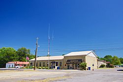
Town Hall
|
||
|
||

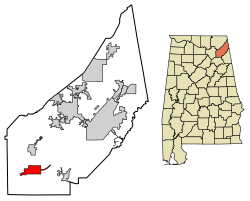
Location of Crossville in DeKalb County, Alabama.
|
||
| Country | United States | |
| State | Alabama | |
| County | DeKalb | |
| Government | ||
| • Type | Mayor-Council | |
| Area | ||
| • Total | 8.36 sq mi (21.66 km2) | |
| • Land | 8.36 sq mi (21.66 km2) | |
| • Water | 0.00 sq mi (0.00 km2) | |
| Elevation | 1,132 ft (345 m) | |
| Population
(2020)
|
||
| • Total | 1,830 | |
| • Density | 218.82/sq mi (84.49/km2) | |
| Time zone | UTC-6 (Central (CST)) | |
| • Summer (DST) | UTC-5 (CDT) | |
| ZIP code |
35962
|
|
| Area code(s) | 256 | |
| FIPS code | 01-18856 | |
| GNIS feature ID | 2406341 | |
Crossville is a town in DeKalb County, Alabama, in the United States. In 2010, about 1,862 people lived there. Crossville is located on top of Sand Mountain. This mountain is a southern part of the Cumberland Plateau.
Contents
History of Crossville
Crossville is a farming community in northeast Alabama. It sits on a high, flat area called Sand Mountain. Native American people used to call this area Raccoon Mountain. The land was good for farming and hunting. It also had a nice climate and was close to streams. This made it a good place for early settlers to live. Many people moved here from nearby states.
Sand Mountain was in an area where the borders between the Creek and Cherokee Native American groups were not clear. Even after Alabama became a state in 1819, much of northern Alabama was still officially Cherokee land. More and more settlers moved into the area. This became a bigger issue when gold was found in nearby Georgia.
Even though the gold rush ended, more farmers kept settling here. This led to the forced removal of the Cherokee, Creek, and Choctaw nations from their homes. This difficult journey is known as the Trail of Tears. Thousands of Native Americans died during this forced move. In nearby Fort Payne, there is a sign marking it as a starting point for the Trail of Tears. This area was also where Sequoyah lived. He created the Cherokee alphabet.
During the American Civil War, DeKalb County, where Crossville is, was not a major area for large farms that used enslaved people. Most people in this area were poor and worked hard with their own hands. Before the Civil War, DeKalb County voted against leaving the United States. Some counties in Northern Alabama and East Tennessee even thought about forming their own state called Nickajack. They did not want to join the states that left the Union.
During the Civil War, many families from the mountains, like Sand Mountain, tried to stay out of the fighting at first. They saw it as a "rich man's war." But as the war went on, many DeKalb County families joined the Union side. They fought in groups like the 1st Tennessee & Alabama Independent Vidette Cavalry and the 1st Alabama Cavalry Regiment. The First Alabama Cavalry was special because it was one of the few groups that had both white and Black soldiers.
James A. Copeland (1880–1964) gave Crossville its name. He wanted the name to show that many roads crossed there.
In the mid-1800s, mail came to Crossville by stagecoach from Rome, Georgia, and Guntersville, Alabama. Soon, Crossville got its first U.S. post office. A.C. Copeland was the first postmaster. In 1888, George Wyatt Justice started the first business in Crossville. In 1903, W.B. Jones set up machines for his cotton mills. The Jones family was very important for Crossville's early growth.
The first church in the Crossville area was a Methodist Episcopal Church called Pine Bark Church. It started just before the Civil War. The town's first Baptist church was built in 1892. In 1925, the First Baptist Church of Crossville was formed. A new church building was finished in 1926.
Crossville started its first school in the late 1800s. It was a one-room building with one teacher and about 50 students. The first bank was started in 1914 by N.W. Black and Boyce Rains. Soon after, Crossville became an official town for a short time. Charlie J. Crump was chosen as the first mayor. But not much happened, and the town's official status ended.
The town became official again on December 21, 1942. Dr. Luther F. Erwin was chosen as mayor. The town government made rules and collected money from businesses. But they didn't collect enough money to keep up basic town services. After this, C.W. (Bill) Russell was elected mayor. He worked with a legal adviser to create a strong town government. This government set up ways to collect taxes and provide basic services. This became the foundation for the Crossville of today.
Geography and Location
Crossville is in the southwestern part of DeKalb County. Its exact location is 34°17′12″N 85°59′27″W / 34.28667°N 85.99083°W. Alabama State Route 68 is the main road that goes through the town. This road goes east about 9 miles (14 km) to Interstate 59 at Collinsville. It goes west about 14 miles (23 km) to Albertville. Alabama State Route 227 also passes through Crossville. It goes north about 5 miles (8 km) to Geraldine. It goes south about 7 miles (11 km) into Big Wills Valley.
The U.S. Census Bureau says that Crossville covers a total area of about 8.36 square miles (21.7 square kilometers). All of this area is land.
Population and People
| Historical population | |||
|---|---|---|---|
| Census | Pop. | %± | |
| 1930 | 316 | — | |
| 1940 | 436 | 38.0% | |
| 1950 | 609 | 39.7% | |
| 1960 | 579 | −4.9% | |
| 1970 | 1,035 | 78.8% | |
| 1980 | 1,222 | 18.1% | |
| 1990 | 1,350 | 10.5% | |
| 2000 | 1,431 | 6.0% | |
| 2010 | 1,862 | 30.1% | |
| 2020 | 1,830 | −1.7% | |
| U.S. Decennial Census 2013 Estimate |
|||
2020 Census Information
| Race | Num. | Perc. |
|---|---|---|
| White (non-Hispanic) | 1,485 | 81.15% |
| Black or African American (non-Hispanic) | 6 | 0.33% |
| Native American | 31 | 1.69% |
| Asian | 2 | 0.11% |
| Pacific Islander | 3 | 0.16% |
| Other/Mixed | 56 | 3.06% |
| Hispanic or Latino | 247 | 13.5% |
In 2020, the town had 1,830 people living there. There were 707 households and 455 families.
2010 Census Information
In 2010, Crossville had a population of 1,862 people.
- About 87.2% of the people were white (not Hispanic).
- About 0.4% were Black.
- About 1.9% were Native American.
- About 0.2% were Asian.
- About 0.1% were Pacific Islander.
- About 6.3% were from another race.
- About 2.4% were from two or more races.
- About 8.3% of the people were Hispanic or Latino of any race.
Climate and Weather
Crossville has a climate with warm temperatures and rain spread out evenly through the year. This type of climate is called a "Humid Subtropical Climate".
| Climate data for Crossville | |||||||||||||
|---|---|---|---|---|---|---|---|---|---|---|---|---|---|
| Month | Jan | Feb | Mar | Apr | May | Jun | Jul | Aug | Sep | Oct | Nov | Dec | Year |
| Mean daily maximum °C (°F) | 9 (49) |
12 (54) |
17 (62) |
22 (71) |
26 (78) |
29 (85) |
31 (88) |
31 (88) |
28 (82) |
22 (72) |
16 (61) |
11 (52) |
21 (70) |
| Mean daily minimum °C (°F) | −1 (30) |
0 (32) |
4 (40) |
9 (48) |
13 (56) |
17 (63) |
19 (67) |
19 (66) |
16 (60) |
9 (48) |
4 (39) |
0 (32) |
9 (48) |
| Average precipitation mm (inches) | 130 (5.2) |
130 (5) |
150 (5.9) |
120 (4.9) |
110 (4.4) |
100 (4) |
110 (4.3) |
86 (3.4) |
110 (4.4) |
79 (3.1) |
110 (4.4) |
130 (5.1) |
1,380 (54.2) |
| Source: Weatherbase | |||||||||||||
Schools in Crossville
Crossville has three schools:
- Crossville Elementary
- Crossville Middle
- Crossville High
These schools are part of the DeKalb County School System. Crossville High is known as the home of the Lions. For the 2023–2024 school year, Crossville is a 5A school. This means it has the largest school classification in DeKalb County. The school colors are black and gold. The principal of Crossville High is Jon Peppers. Brian Pool is the principal of Crossville Middle. Kristin Williams is the principal of Crossville Elementary.
See also
In Spanish: Crossville (Alabama) para niños
 | Bessie Coleman |
 | Spann Watson |
 | Jill E. Brown |
 | Sherman W. White |


