Albertville, Alabama facts for kids
Quick facts for kids
Albertville, Alabama
|
|||
|---|---|---|---|
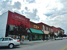
Albertville in 2012
|
|||
|
|||
| Nickname(s):
The Heart of Sand Mountain
|
|||
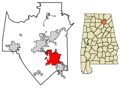
Location in Marshall County, Alabama
|
|||
| Country | United States | ||
| State | Alabama | ||
| County | Marshall | ||
| Founded | 1850 | ||
| Incorporated | February 18, 1891 | ||
| Government | |||
| • Type | Mayor Council | ||
| Area | |||
| • City | 27.037 sq mi (70.026 km2) | ||
| • Land | 26.937 sq mi (69.766 km2) | ||
| • Water | 0.100 sq mi (0.259 km2) | ||
| Elevation | 1,024 ft (312 m) | ||
| Population
(2020)
|
|||
| • City | 22,386 | ||
| • Estimate
(2022)
|
22,726 | ||
| • Density | 844/sq mi (325.7/km2) | ||
| • Urban | 38,476 | ||
| • Urban density | 1,104/sq mi (426.4/km2) | ||
| • Metro | 99,423 | ||
| • Metro density | 175.7/sq mi (67.84/km2) | ||
| Time zone | UTC−6 (Central (CST)) | ||
| • Summer (DST) | UTC−5 (CDT) | ||
| ZIP Codes |
35950, 35951
|
||
| Area code(s) | 256 and 938 | ||
| FIPS code | 01-00988 | ||
| GNIS feature ID | 2403074 | ||
Albertville is a city located in Marshall County, Alabama, in the United States. It is part of the larger Huntsville-Decatur Combined Statistical Area. In 2020, the city had a population of 22,386 people. Albertville is the biggest city in Marshall County.
Contents
History of Albertville
Early Days and Founding
The land where Albertville now stands was once home to the Cherokee people. They lived there until they were moved to Oklahoma in the 1830s. This area was also close to the Creek nation. Important trails used for communication and travel between these groups crossed through here. Some historians believe that Spanish explorer Hernando de Soto traveled through this area in 1540.
During the American Civil War, there were some battles between Union and Confederate soldiers near Albertville.
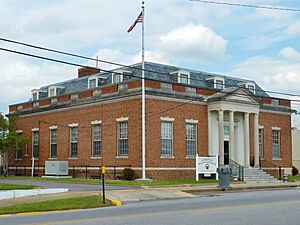
The first non-Native American settlers arrived in the 1850s. The city was named after Thomas A. Albert. He was an early settler from Georgia and a key leader in the town until he passed away in 1876. Albertville officially became a city in 1891. A post office was opened in 1910.
The Great Cyclone of 1908
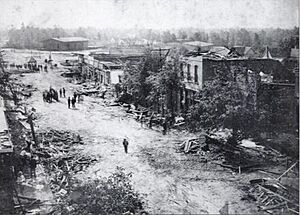
On April 24, 1908, a very strong tornado hit Albertville around 4:10 p.m. This storm was known as "The Great Cyclone." It almost completely destroyed the city. The tornado killed 35 people across northeastern Alabama, with 15 deaths in Albertville.
Help arrived mainly by railroad, especially from the nearby city of Gadsden. Trains brought doctors, nurses, and soldiers to help the injured and clear the damage. A military leader described the destruction as "unprecedented" and "complete and absolute."
Growth and Development
In 1893, Alabama decided to build an agricultural college in each part of the state. Albertville was chosen for the college in its district. This school later became Albertville High School. Its sports teams are still called the "Aggies."
By 1910, Albertville had 1,544 people. It became the largest community in Marshall County.
Before the New Deal programs, the Tennessee River often flooded. This made it hard for people in Albertville to reach the county courthouse in Guntersville. So, in 1919, a new law required a courthouse to be built in Albertville. This way, local cases could be heard closer to home.
In 1950, Albertville's population grew to 5,397. It became the largest city in the county again, and it has stayed that way ever since.
On June 1, 2009, the city council voted to make English the town's official language.
On April 24, 2010, another strong tornado, an EF-3, hit downtown Albertville. Luckily, no one died in this storm. The high school was badly damaged, and many homes were destroyed or needed major repairs.
Geography of Albertville
Albertville is located in the southeastern part of Marshall County. It shares borders with the city of Boaz to the southeast and Guntersville to the northwest.
Land and Water
The city covers about 27 square miles (70 square kilometers). Most of this area is land, with a small amount of water.
Albertville sits on top of Sand Mountain. This is a flat area, or plateau, that is about 15 miles (24 km) wide here. The city is about 1,060 feet (323 meters) above sea level. The "Tennessee Valley Divide" runs through the southern part of the city. This means water in the northern part flows towards the Tennessee River. Water in the southern part flows towards the Locust Fork of the Black Warrior River. Albertville's slogan is "The Heart of Sand Mountain."
Climate in Albertville
| Climate data for Albertville, Alabama | |||||||||||||
|---|---|---|---|---|---|---|---|---|---|---|---|---|---|
| Month | Jan | Feb | Mar | Apr | May | Jun | Jul | Aug | Sep | Oct | Nov | Dec | Year |
| Mean daily maximum °F (°C) | 51.2 (10.7) |
54.1 (12.3) |
62.3 (16.8) |
71.8 (22.1) |
79.6 (26.4) |
86.9 (30.5) |
88.7 (31.5) |
88.2 (31.2) |
83.5 (28.6) |
73.9 (23.3) |
61.2 (16.2) |
52.9 (11.6) |
71.2 (21.8) |
| Mean daily minimum °F (°C) | 32.5 (0.3) |
33.7 (0.9) |
40.4 (4.7) |
48.8 (9.3) |
56.9 (13.8) |
63.8 (17.7) |
66.9 (19.4) |
66.0 (18.9) |
60.4 (15.8) |
49.6 (9.8) |
39.2 (4.0) |
33.8 (1.0) |
49.3 (9.6) |
| Average precipitation inches (mm) | 5.3 (130) |
5.0 (130) |
6.3 (160) |
4.6 (120) |
4.3 (110) |
3.5 (89) |
4.7 (120) |
3.6 (91) |
3.4 (86) |
2.9 (74) |
3.6 (91) |
5.1 (130) |
52.4 (1,330) |
| Source: Weatherbase | |||||||||||||
People of Albertville: Demographics
Population Growth Over Time
| Historical population | |||
|---|---|---|---|
| Census | Pop. | %± | |
| 1910 | 1,544 | — | |
| 1920 | 1,666 | 7.9% | |
| 1930 | 2,716 | 63.0% | |
| 1940 | 3,651 | 34.4% | |
| 1950 | 5,397 | 47.8% | |
| 1960 | 8,250 | 52.9% | |
| 1970 | 9,963 | 20.8% | |
| 1980 | 12,039 | 20.8% | |
| 1990 | 14,507 | 20.5% | |
| 2000 | 17,247 | 18.9% | |
| 2010 | 21,160 | 22.7% | |
| 2020 | 22,386 | 5.8% | |
| 2022 (est.) | 22,726 | 7.4% | |
| U.S. Decennial Census 2020 Census |
|||
Albertville first appeared as a town in the U.S. Census in 1910. Its population has grown steadily over the years.
Albertville in 2020
| Race | Number | Percent |
|---|---|---|
| White (non-Hispanic) | 12,821 | 57.27% |
| Black or African American (non-Hispanic) | 1,030 | 4.6% |
| Native American | 73 | 0.33% |
| Asian | 178 | 0.8% |
| Pacific Islander | 14 | 0.06% |
| Other/Mixed | 725 | 3.24% |
| Hispanic or Latino | 7,545 | 33.7% |
According to the 2020 census, Albertville had 22,386 people. There were 7,671 households and 5,487 families living in the city.
Albertville in 2010
In the 2010 census, Albertville had 21,160 people. About 75.9% of the people were White, and 27.9% were Hispanic or Latino.
In 2010, 34.6% of households had children under 18. The average household had 2.79 people. The median age in the city was 32.3 years old.
The average income for a household was $35,843. About 23.6% of the population lived below the poverty line. This included 35.6% of those under 18.
Albertville Precinct/Division (1880–1970); Albertville-Boaz Division (1980–)
| Historical population | |||
|---|---|---|---|
| Census | Pop. | %± | |
| 1880 | 569 | — | |
| 1890 | 1,388 | 143.9% | |
| 1900 | 2,479 | 78.6% | |
| 1910 | 3,820 | 54.1% | |
| 1920 | 4,322 | 13.1% | |
| 1930 | 5,309 | 22.8% | |
| 1940 | 5,873 | 10.6% | |
| 1950 | 7,839 | 33.5% | |
| 1960 | 12,044 | 53.6% | |
| 1970 | 13,756 | 14.2% | |
| 1980 | 24,970 | 81.5% | |
| 1990 | 26,537 | 6.3% | |
| 2000 | 31,407 | 18.4% | |
| 2010 | 37,950 | 20.8% | |
| 2020 | 40,671 | 7.2% | |
| U.S. Decennial Census 2020 Census |
|||
The Albertville area has been counted in the U.S. Census since 1880. In 1980, the Albertville and Boaz Census Divisions joined to form the Albertville-Boaz Census Division.
Economy of Albertville
Albertville is known for several important industries.
- Fire Hydrant Capital: The Mueller Company makes fire hydrants here. Because of this, Albertville is called the "Fire Hydrant Capital of the World." A special chrome fire hydrant is displayed to celebrate making one million hydrants.
- Poultry Industry: Several large poultry companies have plants in Albertville. These include Wayne Farms, Pilgrim's Pride, and Tyson Foods.
- Grocery Distribution: Mitchell Grocery Corporation is located in Albertville. It is a major center that distributes groceries to over 200 independent supermarkets in the Southeast.
- Auto Parts: In 2012, Newman Technology started building an auto parts factory in Albertville. This factory makes parts for Honda, Acura, and Toyota cars. It began operating in early 2013.
Education in Albertville
Public schools in Albertville are managed by Albertville City Schools. There are six schools in the city:
- Albertville Kindergarten and Pre-K (Kindergarten)
- Albertville Primary School (1st and 2nd grades)
- Albertville Elementary School (3rd and 4th grades)
- Albertville Intermediate School (5th and 6th grades)
- Albertville Middle School (7th and 8th grades)
- Albertville High School (9th through 12th grades)
Albertville's Infrastructure
Transportation
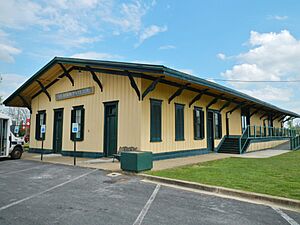
Albertville has several ways to get around:
- U.S. Highway 431
- Alabama Highway 75
- Alabama State Route 205
- Thomas J. Brumlik Field (Albertville Regional Airport)
- Alabama and Tennessee River Railway
Healthcare
- Marshall Medical Center South is a hospital in the area. It has 150 beds and serves the region.
Notable People from Albertville
Many interesting people have come from Albertville, including:
- Edward Earl Carnes: A judge for the United States Court of Appeals.
- Rusty Greer: A professional baseball player for the Texas Rangers.
- Charley Hannah: A former professional football player.
- John Hannah: A professional football offensive lineman. He was elected to the Pro Football Hall of Fame.
- Glenn Hearn: A former mayor of Huntsville, Alabama, and an FBI Special Agent.
- Ola L. Mize: A United States Army officer who received the Medal of Honor for his bravery in the Korean War.
- Charley Pell: A former head football coach at Clemson University and the University of Florida.
- Susan Story: A leader in the utility industry.
- Bobby Thomason: The first professional football quarterback to throw for over 400 yards in a single game.
See also
 In Spanish: Albertville (Alabama) para niños
 | Misty Copeland |
 | Raven Wilkinson |
 | Debra Austin |
 | Aesha Ash |


