
Gadsden, Alabama facts for kids
Quick facts for kids
Gadsden, Alabama
|
|||||
|---|---|---|---|---|---|
.jpg)
Aerial photo of downtown Gadsden
|
|||||
|
|||||
| Motto(s):
"City of Champions"
|
|||||

Location of Gadsden in Etowah County, Alabama
|
|||||
| Country | United States | ||||
| State | Alabama | ||||
| County | Etowah | ||||
| Founded | February 18, 1867 | ||||
| Incorporated | March 9, 1871 | ||||
| Government | |||||
| • Type | Mayor Council (with seven councilmen) | ||||
| Area | |||||
| • City | 38.657 sq mi (100.121 km2) | ||||
| • Land | 37.443 sq mi (96.978 km2) | ||||
| • Water | 1.214 sq mi (3.143 km2) | ||||
| Elevation | 581 ft (177 m) | ||||
| Population
(2020)
|
|||||
| • City | 33,945 | ||||
| • Estimate
(2022)
|
33,335 | ||||
| • Rank | US: 1200th AL: 16th |
||||
| • Density | 890/sq mi (343.8/km2) | ||||
| • Urban | 57,975 (US: 460th) | ||||
| • Urban density | 947/sq mi (365.7/km2) | ||||
| • Metro | 103,088 (US: 357th) | ||||
| • Metro density | 192.6/sq mi (74.38/km2) | ||||
| Time zone | UTC−6 (Central (CST)) | ||||
| • Summer (DST) | UTC−5 (CDT) | ||||
| ZIP Codes |
35901, 35902, 35903, 35904, 35905, 35906, 35907
|
||||
| Area code(s) | 256 and 938 | ||||
| FIPS code | 01-28696 | ||||
| GNIS feature ID | 2403673 | ||||


Gadsden is a city in Alabama, a state in the United States. It is the main city of Etowah County. Gadsden is located on the Coosa River. It is about 56 miles northeast of Birmingham. The city is also about 90 miles southwest of Chattanooga, Tennessee. In 2020, about 33,945 people lived in Gadsden.
In the 1800s, Gadsden was a very important center for business and factories in Alabama. Only Mobile was more important. Both cities were key for shipping goods. Gadsden used riverboats, and Mobile handled international trade.
From the late 1800s until the 1980s, Gadsden was known for its heavy industry. Big companies like Goodyear Tire and Rubber Company and Republic Steel were here. In 1991, Gadsden was given the All-America City Award. This award recognized the city's efforts to improve after many factories closed.
Contents
History of Gadsden
The first group of European-American settlers came to this area around 1825. They started a village called "Double Springs." John Riley, who was part American Indian and part European-American, built his house near two springs. His house was a stop for stagecoaches traveling between Huntsville and Rome. This building is still the oldest one in Gadsden today.
In 1840, brothers Gabriel and Asenath Hughes bought Riley's house. They also bought a lot of land nearby. The brothers wanted to build a railroad from Savannah, Georgia, to Nashville, Tennessee. This railroad would pass through their land. The first survey of Gadsden included the Hughes brothers' land and land from John S. Moragne and Lewis L. Rhea.
On July 4, 1845, a steamboat called Coosa arrived at the settlement. Captain James Lafferty was the pilot. The Hughes brothers suggested naming the town "Lafferty's Landing." But the people living there chose "Gadsden" instead. They named it after Colonel James Gadsden from South Carolina. He later became famous for buying land from Mexico for the United States. This land deal was called the Gadsden Purchase.
After the American Civil War, in 1867, Gadsden became the county seat of a new county called Baine County. A county seat is the main town where the county government is located. In 1868, Baine County was renamed Etowah County, and Gadsden remained its county seat.
By the late 1800s, Gadsden was a major port on the Coosa River. It was the second most important port in Alabama, after Mobile. It also became a big center for heavy industry.
Gadsden in the 20th Century
In the 1900s, factory workers in Gadsden could earn good wages. This helped them live better lives. The city's population was largest in 1960.
However, in the 1970s and 1980s, many of Gadsden's big factories closed down. This happened because of changes in industries across the country. The city lost many jobs and people moved away. Gadsden's government has been working hard to create new types of jobs and improve the city.
Efforts to make the city better, like creating a Cultural Arts Center, helped Gadsden win an award in 2000. It was recognized for its "City Livability Awards Program."
Geography and Climate
Gadsden is located in the middle of Etowah County. It sits on both sides of the Coosa River. The city covers about 38.66 square miles. Most of this is land, and a small part is water. The southern end of Lookout Mountain is just north of the city center.
Gadsden has a humid subtropical climate. This means it has four clear seasons.
- Winter: From early December to late February. January is usually the coldest month. It rarely snows, but it rains a lot.
- Summer: From mid-May to mid-September. Summers are hot and humid. July is usually the hottest month.
- Autumn: From mid-September to early December. Autumn is similar to spring in temperature and rain.
The highest temperature ever recorded in Gadsden was 106°F (41°C) on June 30, 2012. The lowest temperature was -6°F (-21°C) on January 20–21, 1985.
| Climate data for Gadsden, Alabama (1991–2020 normals, extremes 1953–present) | |||||||||||||
|---|---|---|---|---|---|---|---|---|---|---|---|---|---|
| Month | Jan | Feb | Mar | Apr | May | Jun | Jul | Aug | Sep | Oct | Nov | Dec | Year |
| Record high °F (°C) | 78 (26) |
82 (28) |
88 (31) |
91 (33) |
99 (37) |
106 (41) |
105 (41) |
105 (41) |
102 (39) |
99 (37) |
87 (31) |
78 (26) |
106 (41) |
| Mean maximum °F (°C) | 70.1 (21.2) |
73.9 (23.3) |
80.9 (27.2) |
86.5 (30.3) |
90.9 (32.7) |
95.2 (35.1) |
97.0 (36.1) |
97.4 (36.3) |
94.4 (34.7) |
87.4 (30.8) |
78.6 (25.9) |
71.0 (21.7) |
98.5 (36.9) |
| Mean daily maximum °F (°C) | 52.8 (11.6) |
57.3 (14.1) |
66.0 (18.9) |
74.9 (23.8) |
82.0 (27.8) |
87.8 (31.0) |
90.9 (32.7) |
90.3 (32.4) |
85.3 (29.6) |
75.4 (24.1) |
64.0 (17.8) |
55.6 (13.1) |
73.5 (23.1) |
| Daily mean °F (°C) | 42.8 (6.0) |
46.7 (8.2) |
54.7 (12.6) |
62.7 (17.1) |
70.7 (21.5) |
77.9 (25.5) |
81.0 (27.2) |
80.4 (26.9) |
74.8 (23.8) |
64.0 (17.8) |
52.7 (11.5) |
45.6 (7.6) |
62.8 (17.1) |
| Mean daily minimum °F (°C) | 32.8 (0.4) |
36.2 (2.3) |
43.3 (6.3) |
50.4 (10.2) |
59.4 (15.2) |
67.9 (19.9) |
71.2 (21.8) |
70.4 (21.3) |
64.3 (17.9) |
52.5 (11.4) |
41.3 (5.2) |
35.7 (2.1) |
52.1 (11.2) |
| Mean minimum °F (°C) | 16.4 (−8.7) |
21.6 (−5.8) |
26.9 (−2.8) |
36.1 (2.3) |
45.9 (7.7) |
58.4 (14.7) |
64.9 (18.3) |
63.5 (17.5) |
52.3 (11.3) |
37.4 (3.0) |
27.0 (−2.8) |
22.0 (−5.6) |
15.1 (−9.4) |
| Record low °F (°C) | −6 (−21) |
1 (−17) |
11 (−12) |
22 (−6) |
33 (1) |
42 (6) |
52 (11) |
52 (11) |
33 (1) |
23 (−5) |
14 (−10) |
1 (−17) |
−6 (−21) |
| Average precipitation inches (mm) | 5.70 (145) |
5.18 (132) |
5.40 (137) |
5.07 (129) |
4.79 (122) |
4.56 (116) |
4.71 (120) |
4.49 (114) |
4.50 (114) |
3.51 (89) |
4.25 (108) |
5.48 (139) |
57.64 (1,464) |
| Average snowfall inches (cm) | 0.0 (0.0) |
0.1 (0.25) |
0.0 (0.0) |
0.0 (0.0) |
0.0 (0.0) |
0.0 (0.0) |
0.0 (0.0) |
0.0 (0.0) |
0.0 (0.0) |
0.0 (0.0) |
0.0 (0.0) |
0.1 (0.25) |
0.2 (0.51) |
| Average precipitation days (≥ 0.01 in) | 9.7 | 10.3 | 10.2 | 9.1 | 8.2 | 9.6 | 9.6 | 8.4 | 6.3 | 6.5 | 7.9 | 10.3 | 106.1 |
| Average snowy days (≥ 0.1 in) | 0.1 | 0.1 | 0.0 | 0.0 | 0.0 | 0.0 | 0.0 | 0.0 | 0.0 | 0.0 | 0.0 | 0.0 | 0.2 |
| Source: NOAA | |||||||||||||
Population of Gadsden
| Historical population | |||
|---|---|---|---|
| Census | Pop. | %± | |
| 1880 | 1,697 | — | |
| 1890 | 2,901 | 70.9% | |
| 1900 | 4,282 | 47.6% | |
| 1910 | 10,557 | 146.5% | |
| 1920 | 14,737 | 39.6% | |
| 1930 | 24,042 | 63.1% | |
| 1940 | 36,975 | 53.8% | |
| 1950 | 55,725 | 50.7% | |
| 1960 | 58,088 | 4.2% | |
| 1970 | 53,928 | −7.2% | |
| 1980 | 47,565 | −11.8% | |
| 1990 | 42,523 | −10.6% | |
| 2000 | 38,978 | −8.3% | |
| 2010 | 36,856 | −5.4% | |
| 2020 | 33,945 | −7.9% | |
| 2022 (est.) | 33,335 | −9.6% | |
| U.S. Decennial Census 2020 Census |
|||
Gadsden's Population in 2020
| Race | Number | Percent |
|---|---|---|
| White (non-Hispanic) | 17,198 | 50.66% |
| Black or African American (non-Hispanic) | 12,002 | 35.36% |
| Native American | 92 | 0.27% |
| Asian | 273 | 0.8% |
| Pacific Islander | 9 | 0.03% |
| Other/mixed | 1,633 | 4.81% |
| Hispanic or Latino | 2,738 | 8.07% |
In 2020, Gadsden had 33,945 people living in the city. There were 14,141 households and 8,411 families.
Gadsden's Population in 2010
In 2010, Gadsden had 36,856 people. About 57.3% were White, and 36.3% were Black or African American. About 5.4% of the people were Hispanic or Latino.
About 22.5% of the population was under 18 years old. The average age of people in Gadsden was 39.3 years.
Jobs in Gadsden

Many people in Gadsden work for hospitals, schools, and large companies. Here are some of the biggest employers in the city:
Top Employers in Gadsden
| Number | Company/Organizations | Employees |
|---|---|---|
| 1 | Gadsden Regional Medical Center | 1,312 |
| 2 | Etowah County Board of Education | 1,275 |
| 3 | Koch Foods | 1,040 |
| 4 | Riverview Regional Medical Center | 789 |
| 5 | Walmart | 750 |
| 6 | Gadsden City Schools | 693 |
| 7 | City of Gadsden | 658 |
| 8 | Gadsden State Community College | 553 |
| 9 | Keystone Foods | 512 |
| 10 | Feher Automotive | 434 |
Religion in Gadsden
Gadsden has many different churches. These include Episcopalian, Methodist, Baptist, Presbyterian, Lutheran, and Catholic churches. There are also Church of Christ, Pentecostal, Church of the Nazarene, and Church of Jesus Christ of Latter Day Saints.
The city was once home to Congregation Beth Israel, a Reform synagogue. It was founded in 1908. The synagogue closed in 2010 because fewer members were attending.
Law Enforcement
Gadsden has its own police department with 106 members. It has a Patrol Division and a Detective Division. The Patrol Division includes a bomb squad and a special projects team. It also works with the Etowah County Sheriff Office on a SWAT team. The Detective Division handles different types of cases, like property crimes and cases involving young people.
In 2010, the Gadsden Police Department got two unmanned aerial vehicles (UAVs), also known as drones. These drones have video cameras and can send signals wirelessly. They are used for watching over areas from the air.
Education in Gadsden
The Gadsden City Board of Education manages fourteen schools. There are eight elementary schools, three middle schools, and one high school. There are also two special schools: an alternative center and a technical center.
A new high school, Gadsden City High School, opened for the 2006–2007 school year. It combined three older high schools: Emma Sansom High School, Gadsden High School, and Litchfield High School.
Gadsden is also home to Gadsden State Community College. This is the second largest two-year college in Alabama. Small parts of Jacksonville State University and the University of Alabama also offer college classes in Gadsden.
Gadsden has the first statewide program in Alabama for young people who have been in trouble. It is called the Community Intensive Treatment for Youth Program (C.I.T.Y.). It started in 1981. The program helps young people on probation learn important skills for life. It helps them with reading, math, and language. It also teaches them about managing money and getting ready for jobs. After the program, young people can prepare for their GED, go back to public school, or go to technical school, college, or join the military. In 1983, the C.I.T.Y. Program won a national award for being unique and innovative. In 2009, its name changed to Special Programming for Achievement Network (S.P.A.N.).
Media
Newspapers
- The Gadsden Times: This is a daily morning newspaper.
- Gadsden Messenger: This is a weekly newspaper owned by local people.
- The Reporter: This is a monthly newspaper also owned by local people.
Television
Gadsden is part of the Birmingham TV market. Two TV stations are licensed to Gadsden:
- WTJP Channel 60 - Trinity Broadcasting Network
- WPXH Channel 44 - ION Television
- W15AP Channel 15 - This repeats the signal for WBRC Fox 6 in Birmingham.
AM Radio
- WAAX 570 - News and talk shows
- WGAD 930 - Light pop music
- WMGJ 1240 - Urban/contemporary music
- WTDR 1350 - Plays country music from 92.7 FM Thunder Country
FM Radio
- WKLS 105.9 – Mainstream rock music
- WKXX 102.9 - Sports talk
- WSGN 91.5 - NPR/PBS (from Gadsden State Community College, also plays WBHM Birmingham)
- WGMZ 93.1 - Classic rock music
- W257CT 99.3 FM - News, talk, and classic 80s music on weekends
- WTBB 89.9 - Religious programs
Transportation
Gadsden has several ways to get around:
- Gadsden Trolley System
- Greyhound Lines (bus service)
- Interstate 59
- Interstate 759
- U.S. Highway 411
- U.S. Highway 431
- U.S. Highway 278
- Norfolk Southern Railway
- Alabama and Tennessee River Railway
- Northeast Alabama Regional Airport (the city's airport)
Notable People from Gadsden
Many interesting people have come from Gadsden, Alabama:
- Clever, a singer, songwriter, and musician
- Jean Cox, an opera singer known for his powerful voice
- W. T. Ewing, a politician, doctor, and postmaster
- Beth Grant, an actress
- Bill Green, a basketball player
- Steve Grissom, a former NASCAR driver
- James Hood, one of the first African Americans to attend the University of Alabama in 1963
- Dre Kirkpatrick, a football player for the NFL's Cincinnati Bengals
- Freddie Kitchens, a football coach
- Mathew Knowles, a music executive and manager, father of Beyoncé
- Annie Lee (1935–2014), an artist
- Sunny Mabrey, an actress
- Jerry McCain, a blues musician known for playing the harmonica
- Darnell Mooney, a wide receiver for the Chicago Bears
- Roy Moore, a former Chief Justice of the Supreme Court of Alabama
- Aaron Pearson, a former football linebacker for the Kansas City Chiefs
- William L. Sibert, a US Army major general who led the U.S. 1st Infantry Division in World War I
- Hazel Brannon Smith, a newspaper publisher who won a Pulitzer Prize
- Cadillac Williams, a former NFL football player
- Yelawolf, a rapper
- Jake Adam York, an award-winning poet
Places to Visit in Gadsden
- Noccalula Falls Park
- Gilliland-Reese Covered Bridge
- Coosa River
- Saigon Village behind Little Bridge Marina
- Downtown Gadsden
- James D. Martin Wildlife Park
- Gadsden Mall
- Gadsden Museum of Art
- Mary G. Hardin Center for Cultural Arts
- Gadsden Symphony Orchestra
- Etowah County Jail, the largest building in downtown Gadsden
Images for kids
-
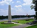
The Spirit of American Citizenship Monument on Rainbow Drive (US 411). The Coosa River is in the background.
See also
 In Spanish: Gadsden (Alabama) para niños
