
Riverside, Alabama facts for kids
Quick facts for kids
Riverside, Alabama
|
|
|---|---|
 |
|

Location of Riverside in St. Clair County, Alabama.
|
|
| Country | United States |
| State | Alabama |
| County | St. Clair |
| Area | |
| • Total | 10.41 sq mi (26.96 km2) |
| • Land | 8.66 sq mi (22.44 km2) |
| • Water | 1.74 sq mi (4.51 km2) |
| Elevation | 505 ft (154 m) |
| Population
(2020)
|
|
| • Total | 2,227 |
| • Density | 257.01/sq mi (99.23/km2) |
| Time zone | UTC-6 (Central (CST)) |
| • Summer (DST) | UTC-5 (CDT) |
| ZIP code |
35135
|
| Area code(s) | 205, 659 |
| FIPS code | 01-64920 |
| GNIS feature ID | 0164834 |
| Website | http://www.riverside-al.com/ |
Riverside is a city located in St. Clair County, Alabama, in the United States. It officially became a city in 1886. In 2020, about 2,227 people lived there.
Contents
Where is Riverside Located?
Riverside is found at 33°36′52″N 86°12′02″W / 33.614465°N 86.200678°W. The city covers a total area of about 10.6 square miles (27.5 square kilometers). Most of this area, about 8.9 square miles (23.1 square kilometers), is land. The rest, about 1.6 square miles (4.1 square kilometers), is water.
The city is right next to the Coosa River. It's also just east of Pell City. Interstate 20 runs through the southern part of Riverside. You can get into the city from exit 162 on I-20.
If you travel west on I-20, you'll reach Birmingham in about 39 miles (63 km). If you go east, Atlanta is about 110 miles (177 km) away. U.S. Route 78 also passes through Riverside.
How Many People Live in Riverside?
The number of people living in Riverside has changed a lot over the years. Here's a look at the population from different census counts:
| Historical population | |||
|---|---|---|---|
| Census | Pop. | %± | |
| 1900 | 300 | — | |
| 1910 | 277 | −7.7% | |
| 1920 | 240 | −13.4% | |
| 1930 | 131 | −45.4% | |
| 1940 | 135 | 3.1% | |
| 1950 | 116 | −14.1% | |
| 1960 | 159 | 37.1% | |
| 1970 | 351 | 120.8% | |
| 1980 | 849 | 141.9% | |
| 1990 | 1,004 | 18.3% | |
| 2000 | 1,564 | 55.8% | |
| 2010 | 2,208 | 41.2% | |
| 2020 | 2,227 | 0.9% | |
| U.S. Decennial Census 2013 Estimate |
|||
Riverside's Population in 2010
In 2010, there were 2,208 people living in Riverside. These people lived in 864 households, and 640 of these were families. The city had about 248 people per square mile (95.8 people per square kilometer). There were 987 homes in total.
Most of the people in Riverside were White (87.5%). About 10.6% were Black or African American. Other groups included Native American (0.2%), Asian (0.7%), and people from two or more races (0.9%). About 1.1% of the population was Hispanic or Latino.
About 30.6% of households had children under 18 living with them. Most households (61.0%) were married couples. About 21.9% of households were just one person.
The average age of people in Riverside was 39.6 years. For every 100 females, there were about 101.8 males.
Riverside's Population in 2020
| Race | Num. | Perc. |
|---|---|---|
| White (non-Hispanic) | 1,800 | 80.83% |
| Black or African American (non-Hispanic) | 257 | 11.54% |
| Native American | 3 | 0.13% |
| Asian | 21 | 0.94% |
| Pacific Islander | 1 | 0.04% |
| Other/Mixed | 92 | 4.13% |
| Hispanic or Latino | 53 | 2.38% |
As of the 2020 census, Riverside had 2,227 people. There were 1,051 households and 780 families living in the city.
Images for kids
-
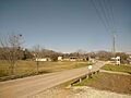
A road in Riverside, Alabama.
-
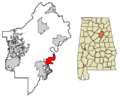
A map showing Riverside in St. Clair County, Alabama.
See also
 In Spanish: Riverside (Alabama) para niños
