Vincent, Alabama facts for kids
Quick facts for kids
Vincent, Alabama
|
|
|---|---|

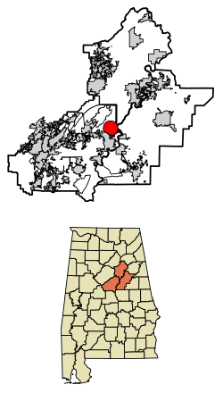
Location of Vincent in Shelby County and St. Clair County and Talladega County, Alabama.
|
|
| Country | United States |
| State | Alabama |
| Counties | Shelby, St. Clair, Talladega |
| Area | |
| • Total | 20.96 sq mi (54.29 km2) |
| • Land | 20.58 sq mi (53.31 km2) |
| • Water | 0.38 sq mi (0.98 km2) |
| Elevation | 466 ft (142 m) |
| Population
(2020)
|
|
| • Total | 1,982 |
| • Density | 96.29/sq mi (37.18/km2) |
| Time zone | UTC-6 (CST) |
| • Summer (DST) | UTC-5 (CDT) |
| ZIP code |
35178
|
| Area code(s) | 205, 659 |
| FIPS code | 01-79008 |
| GNIS feature ID | 2406802 |
Vincent is a city located in the state of Alabama, in the United States. It is unique because it spans across three different counties: Shelby, St. Clair, and Talladega.
The city was first known as Propel. Later, it was renamed Vincent to honor the Vincent family. They were some of the very first people to settle in the area. Vincent officially became a city in 1897. According to the 2020 census, about 1,982 people live there.
Contents
Where is Vincent Located?
Vincent is found at these coordinates: 33°23′9″N 86°24′36″W / 33.38583°N 86.41000°W. This means it is in the northeastern part of Shelby County. Small parts of the city also reach into St. Clair and Talladega counties.
The main road through Vincent is U.S. Route 231. This highway connects Vincent to other towns. For example, it goes northeast about 17 miles (27 km) to Pell City. It also goes southwest about 3 miles (5 km) to Harpersville.
Another important road is Alabama State Route 25. This route splits off from US 231 north of town. It leads northwest about 7 miles (11 km) to Sterrett.
The city covers a total area of about 20.96 square miles (54.29 square kilometers). Most of this area, about 20.58 square miles (53.31 square kilometers), is land. The rest, about 0.38 square miles (0.98 square kilometers), is water.
How Many People Live in Vincent?
| Historical population | |||
|---|---|---|---|
| Census | Pop. | %± | |
| 1900 | 765 | — | |
| 1910 | 995 | 30.1% | |
| 1920 | 1,034 | 3.9% | |
| 1930 | 1,192 | 15.3% | |
| 1940 | 1,108 | −7.0% | |
| 1950 | 1,240 | 11.9% | |
| 1960 | 1,402 | 13.1% | |
| 1970 | 1,419 | 1.2% | |
| 1980 | 1,652 | 16.4% | |
| 1990 | 1,767 | 7.0% | |
| 2000 | 1,853 | 4.9% | |
| 2010 | 1,988 | 7.3% | |
| 2020 | 1,982 | −0.3% | |
| U.S. Decennial Census 2013 Estimate |
|||
Vincent's Population in 2020
The 2020 United States census counted 1,982 people living in Vincent. There were 722 households and 490 families in the town.
| Race | Number of People | Percentage |
|---|---|---|
| White (not Hispanic) | 1,493 | 75.33% |
| Black or African American (not Hispanic) | 384 | 19.37% |
| Native American | 8 | 0.4% |
| Asian | 2 | 0.1% |
| Other/Mixed | 58 | 2.93% |
| Hispanic or Latino | 37 | 1.87% |
Vincent's Population in 2010
In the census of 2010, Vincent had 1,988 people. There were 802 households and 575 families. The population density was about 101 people per square mile (39 per square kilometer).
Most people in Vincent were White (78.7%). About 19.8% were Black or African American. A small number were Native American (0.4%) or Asian (0.1%). About 0.7% of the population was Hispanic or Latino.
About 31.7% of households had children under 18 living with them. About 52.1% were married couples. Around 16.7% had a female head of household with no husband. About 25.4% of households were single individuals.
The average age in Vincent was 42.0 years. About 22.7% of the population was under 18. About 14.6% were 65 years or older.
The average yearly income for a household was estimated at $43,125. For families, it was about $54,640. The income per person in the town was $22,782. About 6.2% of the population lived below the poverty line.
See also
 In Spanish: Vincent (Alabama) para niños
 | Dorothy Vaughan |
 | Charles Henry Turner |
 | Hildrus Poindexter |
 | Henry Cecil McBay |

