
Harpersville, Alabama facts for kids
Quick facts for kids
Harpersville, Alabama
|
|||
|---|---|---|---|
|
|||
| Nickname(s):
Big Springs
|
|||
| Motto(s):
"Rich Past, Bright Future!"
|
|||

Location of Harpersville in Shelby County, Alabama.
|
|||
| Country | United States | ||
| State | Alabama | ||
| County | Shelby | ||
| Area | |||
| • Total | 21.65 sq mi (56.06 km2) | ||
| • Land | 21.29 sq mi (55.15 km2) | ||
| • Water | 0.35 sq mi (0.91 km2) | ||
| Elevation | 436 ft (133 m) | ||
| Population
(2020)
|
|||
| • Total | 1,614 | ||
| • Density | 75.80/sq mi (29.27/km2) | ||
| Time zone | UTC-6 (CST) | ||
| • Summer (DST) | UTC-5 (CDT) | ||
| ZIP code |
35078
|
||
| Area code(s) | 205, 659 | ||
| FIPS code | 01-33256 | ||
| GNIS feature ID | 2406645 | ||
| Website | City Website | ||

Harpersville is a small town located in Shelby County, Alabama, United States. It officially became a town in 1943. In 2020, about 1,614 people lived there. Harpersville is found southeast of the larger Birmingham area.
Contents
History of Harpersville
Harpersville was first settled shortly after the War of 1812 ended. It was originally known by the name Big Springs.
The town is home to two buildings that are listed on the National Register of Historic Places. These important historical sites are the Chancellor House and the Old Rock House.
Datcher Family Farm Museum: A Look into the Past
The Datcher family farm in Harpersville has a long and important history. Its story goes back even before slavery ended in the United States. This farm helps tell the story of family and Black ownership throughout American history. Some trees on the farm are hundreds of years old.
Today, a small, white farmhouse on the property serves as the Datcher family farm museum. Inside, the walls are filled with family photos. These pictures honor the Datcher family's lasting legacy in the area.
Geography of Harpersville
Harpersville is located in the eastern part of Shelby County. Its exact coordinates are 33°19′33″N 86°25′34″W / 33.32583°N 86.42611°W. The town covers a total area of about 15.9 square miles (41.2 square kilometers). Most of this area is land.
The town is situated where two major roads meet: U.S. Route 280 and U.S. Route 231. U.S. Route 280 runs east to west through Harpersville. It leads west about 12 miles (19 km) to Chelsea and 30 miles (48 km) to downtown Birmingham. U.S. Route 280 and U.S. Route 231 go southeast together for 7 miles (11 km) to Childersburg. U.S. Route 231 also goes northeast about 21 miles (34 km) to Pell City.
Population Changes in Harpersville
| Historical population | |||
|---|---|---|---|
| Census | Pop. | %± | |
| 1880 | 194 | — | |
| 1950 | 348 | — | |
| 1960 | 667 | 91.7% | |
| 1970 | 639 | −4.2% | |
| 1980 | 934 | 46.2% | |
| 1990 | 772 | −17.3% | |
| 2000 | 1,620 | 109.8% | |
| 2010 | 1,637 | 1.0% | |
| 2020 | 1,614 | −1.4% | |
| U.S. Decennial Census 2013 Estimate |
|||
The population of Harpersville has changed over the years. In 2010, there were 1,637 people living in the town. By 2020, the population was 1,614. This was a small decrease from the 2010 number.
Harpersville is seeing some growth because more people are moving to areas along Highway 280. However, the most recent census in 2020 showed a slight dip in population compared to the year 2000.
Schools in Harpersville
Harpersville itself does not have public schools within its town limits. All public school students living in Harpersville attend schools in the nearby town of Vincent.
Coosa Valley Academy: A Private School Option
Coosa Valley Academy is a private school located in Harpersville. It is part of the Alabama Independent School Association. The school first opened its doors in 1970 and has been serving the community for over 50 years.
Coosa Valley Academy aims to provide a college preparatory education. They want to create a safe and orderly Christian environment for students. The school encourages students to reach their full academic potential. They also promote mutual respect among students and staff. This helps prepare students for success in life.
The academy offers education for students from Pre-Kindergarten through Twelfth grade. Older students in grades 10-12 can join dual enrollment programs. This allows them to take online classes at Troy University and earn college credits.
Students can participate in many clubs and activities. These include Athletics, Beta Club, Cheerleading Squad, and Dance Team. Other clubs are Fellowship of Christian Athletes, History Club, Spanish Club, Student Government Association, and Ignite Club. The school offers various sports like baseball, basketball, football, soccer, softball, and volleyball.
Currently, about 250 students attend Coosa Valley Academy. There are 22 teachers, which means there is a student-teacher ratio of 11:1. This small ratio allows teachers to work closely with their students.
Notable People from Harpersville
- Warren Kidd, NBA Player
- George McGinnis, NBA Player
- William Joseph Simmons, founder of the second Ku Klux Klan
- Henry B. Walthall, Actor - Star on Hollywood Walk of Fame
Landmarks in Harpersville
- Klein-Wallace Home
Gallery
-
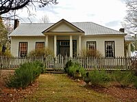
Chancellor House
-
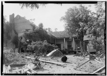
Chancellor House from rear
-

Old Rock House
-
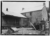
Old Rock House from rear

See also
 In Spanish: Harpersville para niños
