Talladega County, Alabama facts for kids
Quick facts for kids
Talladega County
|
||
|---|---|---|

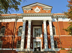
Talladega County Courthouse in Talladega
|
||
|
||
| Motto(s):
"Something For Everyone"
|
||

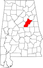
Location within the U.S. state of Alabama
|
||
 Alabama's location within the U.S. |
||
| Country | ||
| State | ||
| Founded | December 18, 1832 | |
| Named for | Creek for “Border Town” | |
| Seat | Talladega | |
| Largest city | Talladega | |
| Area | ||
| • Total | 760 sq mi (2,000 km2) | |
| • Land | 737 sq mi (1,910 km2) | |
| • Water | 24 sq mi (60 km2) 3.1% | |
| Population
(2020)
|
||
| • Total | 82,149 | |
| • Estimate
(2023)
|
81,132 |
|
| • Density | 108.1/sq mi (41.73/km2) | |
| Time zone | UTC−6 (Central) | |
| • Summer (DST) | UTC−5 (CDT) | |
| Congressional district | 3rd | |
|
||
Talladega County is one of 67 counties in Alabama, a state in the southeastern United States. It is located in the east-central part of Alabama. In 2020, about 82,149 people lived here. The main city and government center, called the county seat, is Talladega.
Talladega County is part of a larger area known as the Talladega-Sylacauga Micropolitan Statistical Area. This means it's a region with a city at its center and nearby communities that are closely connected.
Contents
History of Talladega County
Before European settlers arrived, the land that is now Talladega County was home to the Abihka tribe. They were part of the Creek Confederacy, a group of Native American tribes. The United States government made agreements with the Creek people. These agreements led to the Creek tribes giving up their land. Eventually, many Native American groups were moved to lands west of the Mississippi River. This area was called Indian Territory.
Talladega County was officially created on December 18, 1832. This land came from the Creek Indians. The main city, Talladega, became the county seat in 1834.
The name "Talladega" comes from a Muscogee (Creek) Native American word, Tvlvteke. This word means "Border Town." It describes the town's location. It was on the edge of lands belonging to the Creek, Cherokee, and Chickasaw tribes.
Geography of Talladega County
Talladega County covers about 760 square miles. Most of this area, about 737 square miles, is land. The remaining 24 square miles, or 3.1%, is water. Rivers and streams like Choccolocco Creek flow through the county.
The county is located in the Coosa River Valley. It is also part of the Ridge-and-Valley Appalachians region. Mount Cheaha, the highest point in Alabama, is on the border of Talladega County and Cleburne County.
Neighboring Counties
Talladega County shares its borders with several other counties:
- Calhoun County – to the north
- Cleburne County – to the northeast
- Clay County – to the east
- Coosa County – to the south
- Shelby County – to the southwest
- St. Clair County – to the northwest
Protected Natural Areas
Part of the Talladega National Forest is located within Talladega County. This is a large area of protected forest land.
People of Talladega County
The population of Talladega County has changed over time. In 1840, there were about 12,587 people. By 2020, the population had grown to 82,149.
Population in 2020
In 2020, there were 82,149 people living in Talladega County. These people lived in 30,602 households. About 20,515 of these households were families.
The population includes people from different backgrounds.
- About 61.76% of people were White (not Hispanic or Latino).
- About 32.06% were Black or African American (not Hispanic or Latino).
- About 3.03% were of two or more races (not Hispanic or Latino).
- About 2.17% were Hispanic or Latino (of any race).
Population in 2010
In 2010, the county had 82,291 people. There were 31,890 households. About 27.8% of these households had children under 18. The average household had 2.48 people. The average family had 2.98 people.
The median age in the county was 39.3 years. This means half the people were younger than 39.3, and half were older. For every 100 females, there were about 94.9 males.
The median income for a household was $36,948. This is the middle income for all households. About 18.4% of the population lived below the poverty line. This included 27.1% of children under 18.
Education in Talladega County
The main school system in the area is Talladega County Schools. They manage the public schools for children in the county.
There is also a special school for Japanese children. It is called the Birmingham Supplementary School Inc. This school helps Japanese children living in Alabama keep up with their studies in Japanese. Its office is near Lincoln, at the Honda Manufacturing of Alabama facility. Classes are held at Jefferson State Community College in Hoover. The school started in 2001.
Transportation in Talladega County
Talladega County has several important roads and railways.
Major Roads
 Interstate 20
 U.S. Highway 78
 U.S. Highway 231
 U.S. Highway 280
 State Route 21
 State Route 34
 State Route 76
 State Route 77
 State Route 148
 State Route 202
 State Route 235
 State Route 275
Railways
Several railway companies operate in Talladega County. These include CSX Transportation, Norfolk Southern Railway, and Eastern Alabama Railway. Amtrak also has services here.
Cities and Towns
Talladega County has several cities and towns where people live.
Cities
- Childersburg
- Lincoln
- Oxford (partly in Calhoun County)
- Sylacauga
- Talladega (the county seat)
Towns
- Bon Air
- Munford
- Oak Grove
- Talladega Springs
- Vincent (partly in Shelby County and St. Clair County)
- Waldo
Other Communities
- Fayetteville (a census-designated place)
- Mignon (a census-designated place)
Small Communities
- Alpine
- Bemiston (a neighborhood in Talladega)
- Chinnabee
- Curry
- Eastaboga (partly in Calhoun County)
- Fishtrap
- Hopeful
- Kahatchie
- Kentuck
- Laniers
- Liberty Hill
- Mardisville
- Old Eastaboga
- Renfroe
- Sycamore
- Winterboro
Ghost Town
- Gantts Quarry is a former community.
See also
 In Spanish: Condado de Talladega para niños
 | Selma Burke |
 | Pauline Powell Burns |
 | Frederick J. Brown |
 | Robert Blackburn |


