
Gantts Quarry, Alabama facts for kids
Quick facts for kids
Gantts Quarry, Alabama
|
|
|---|---|

Abandoned houses in Gantts Quarry
|
|

Location in Talladega County and the state of Alabama
|
|
| Country | United States |
| State | Alabama |
| County | Talladega |
| Area | |
| • Total | 0.3 sq mi (0.9 km2) |
| • Land | 0.3 sq mi (0.9 km2) |
| • Water | 0 sq mi (0 km2) |
| Elevation | 633 ft (193 m) |
| Population
(2000)
|
|
| • Total | 0 |
| • Density | 0.0/sq mi (0.0/km2) |
| Time zone | UTC-6 (Central (CST)) |
| • Summer (DST) | UTC-5 (CDT) |
| FIPS code | 01-28984 |
| GNIS feature ID | 0118815 |
Gantts Quarry was a small town in Talladega County, Alabama, in the United States. It was once a busy place known for its marble quarry. Today, it is considered a ghost town because no one lives there anymore.
The town was officially created in 1910. Its main goal was to stop the nearby city of Sylacauga from taking over its land. By the year 2000, no one was left living in Gantts Quarry. Because of this, it was officially closed as a town on December 31, 2001.
Contents
History of Gantts Quarry
The story of Gantts Quarry began in 1830. A doctor named Edward Gantt found white marble in the area. This discovery made it one of the first towns in Talladega County. A piece of marble from Gantts Quarry was even used in the famous Washington Monument!
Town's Growth and Decline
In 1930, Gantts Quarry had 542 residents. However, the Great Depression and less demand for marble in buildings caused the town to shrink. By 1940, the population dropped to 456. By 1973, only 63 people lived there. The 1990 U.S. Census showed only seven people remaining.
When the town was first set up, it had a mayor and a five-person city council. There was also a town clerk. The company that owned the quarry built houses for its workers. These were called "company houses."
In the late 1960s, the quarry company decided to tear down these houses. This meant that the people living there had to move to other towns.
Post Office and Final Days
Gantts Quarry even had its own post office. This building also served as a library for the town. The old post office building was later moved. It is now located behind the B.B. Comer Museum in Sylacauga.
By the time of the 2000 Census, the town had no residents. Much of the area seems to have become part of Sylacauga. This was exactly what the town had tried to prevent when it first became official.
Population Changes
The population of Gantts Quarry changed a lot over the years. Here's how many people lived there during different census counts:
| Historical population | |||
|---|---|---|---|
| Census | Pop. | %± | |
| 1920 | 413 | — | |
| 1930 | 542 | 31.2% | |
| 1940 | 456 | −15.9% | |
| 1950 | 426 | −6.6% | |
| 1960 | 238 | −44.1% | |
| 1970 | 63 | −73.5% | |
| 1980 | 71 | 12.7% | |
| 1990 | 7 | −90.1% | |
| 2000 | 0 | −100.0% | |
| U.S. Decennial Census | |||
Location of Gantts Quarry
Gantts Quarry is located in Talladega County. It covers a total area of about 0.9 square kilometers (0.3 square miles). All of this area is land.
Images for kids
-
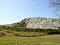
The old marble quarry from which the town got its name.
-
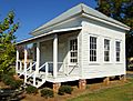
The old Gantts Quarry Post Office, now in Sylacauga.


See also
 In Spanish: Gantts Quarry para niños
