
Cleburne County, Alabama facts for kids
Quick facts for kids
Cleburne County
|
|||
|---|---|---|---|

Cleburne County Courthouse in Heflin, 2012
|
|||
|
|||

Location within the U.S. state of Alabama
|
|||
 Alabama's location within the U.S. |
|||
| Country | |||
| State | |||
| Founded | December 6, 1866 | ||
| Named for | Patrick Cleburne | ||
| Seat | Heflin | ||
| Largest city | Heflin | ||
| Area | |||
| • Total | 561 sq mi (1,450 km2) | ||
| • Land | 560 sq mi (1,500 km2) | ||
| • Water | 0.9 sq mi (2 km2) 0.2% | ||
| Population
(2020)
|
|||
| • Total | 15,056 | ||
| • Estimate
(2023)
|
15,639 |
||
| • Density | 26.838/sq mi (10.362/km2) | ||
| Time zone | UTC−6 (Central) | ||
| • Summer (DST) | UTC−5 (CDT) | ||
| Congressional district | 3rd | ||
|
|||


Cleburne County is a county in the eastern part of Alabama. In 2020, about 15,056 people lived here. Its main town, or county seat, is Heflin. The county is named after Patrick Cleburne, a brave general from Arkansas. Cleburne County shares its eastern border with the state of Georgia.
Contents
History of Cleburne County
Cleburne County was created on December 6, 1866. It was formed from parts of other counties like Benton (now Calhoun), Randolph, and Talladega.
County Seat Changes
In 1867, the town of Edwardsville became the first county seat. Later, in 1905, people voted to move the county seat to Heflin. After some legal discussions, the move to Heflin was approved in 1906. Heflin is still the county seat today.
Early Settlements
Heflin was once an important place for farmers to send their cotton. After the Civil War, a group of investors from the north started a town called Fruithurst. They wanted to grow grapes and make wine there. Fruithurst quickly grew into a busy town.
Geography of Cleburne County
Cleburne County covers about 561 square miles. Most of this area is land, with only a small amount of water. It is one of the smaller counties in Alabama by land size.
Cheaha Mountain
Cleburne County is special because it is home to Cheaha Mountain. This mountain is the highest natural point in all of Alabama! It is part of the Blue Ridge Mountains, which stretch far north.
Neighboring Counties
Cleburne County shares its borders with several other counties:
- Cherokee County to the north
- Polk County, Georgia to the northeast
- Haralson County, Georgia to the east
- Carroll County, Georgia to the southeast
- Randolph County to the south
- Clay County to the southwest
- Talladega County to the southwest
- Calhoun County to the west
Protected Areas
A part of the Talladega National Forest is located within Cleburne County. This forest is a protected area for nature and wildlife.
Transportation in Cleburne County
Getting around Cleburne County is easy with several major roads.
Major Highways
 Interstate 20
 U.S. Highway 78
 U.S. Highway 431
 State Route 9
 State Route 46
 State Route 281
Railways
- Norfolk Southern Railway
- Amtrak (passenger train service)
Population of Cleburne County
| Historical population | |||
|---|---|---|---|
| Census | Pop. | %± | |
| 1870 | 8,017 | — | |
| 1880 | 10,976 | 36.9% | |
| 1890 | 13,218 | 20.4% | |
| 1900 | 13,206 | −0.1% | |
| 1910 | 13,385 | 1.4% | |
| 1920 | 13,360 | −0.2% | |
| 1930 | 12,877 | −3.6% | |
| 1940 | 13,629 | 5.8% | |
| 1950 | 11,904 | −12.7% | |
| 1960 | 10,911 | −8.3% | |
| 1970 | 10,996 | 0.8% | |
| 1980 | 12,595 | 14.5% | |
| 1990 | 12,730 | 1.1% | |
| 2000 | 14,123 | 10.9% | |
| 2010 | 14,972 | 6.0% | |
| 2020 | 15,056 | 0.6% | |
| 2023 (est.) | 15,639 | 4.5% | |
| U.S. Decennial Census 1790–1960 1900–1990 1990–2000 2010–2020 |
|||
In 2020, the census showed that 15,056 people lived in Cleburne County. There were about 5,680 households and 3,806 families.
Education in Cleburne County
Cleburne County has two main public school systems. Around 2,500 students attend public schools from kindergarten through 12th grade. Most of the county is served by the Cleburne County School District. However, the northern part of the county is part of the Piedmont City School District.
School Districts
- Cleburne County School District
- Piedmont City School District
Communities in Cleburne County
Cleburne County has several towns and communities where people live.
City
- Heflin (This is the county seat)
Towns
Census-designated place
Unincorporated Communities
These are smaller communities that are not officially part of a city or town.
- Abel
- Abernathy
- Ai
- Arbacoochee
- Chulafinnee
- Hopewell
- Liberty Hill
- Muscadine
- Trickem
Images for kids
-
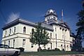
Cleburne County Courthouse in March 1980.
-
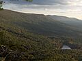
Cheaha Mountain, Cleburne County
-
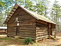
Shoal Creek Church is a historic church located in Cleburne County just north of Edwardsville, Alabama in Talladega National Forest. The church was built in 1895 and added to the National Register of Historic Places on December 4, 1974.


See also
 In Spanish: Condado de Cleburne (Alabama) para niños
