Carroll County, Georgia facts for kids
Quick facts for kids
Carroll County
|
|||
|---|---|---|---|

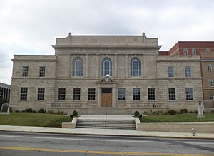
Carroll County Courthouse
|
|||
|
|||

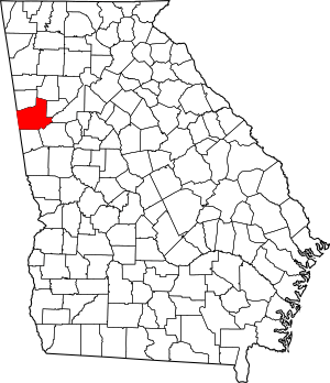
Location within the U.S. state of Georgia
|
|||
 Georgia's location within the U.S. |
|||
| Country | |||
| State | |||
| Founded | June 9, 1826 | ||
| Named for | Charles Carroll of Carrollton | ||
| Seat | Carrollton | ||
| Largest city | Carrollton | ||
| Area | |||
| • Total | 504 sq mi (1,310 km2) | ||
| • Land | 499 sq mi (1,290 km2) | ||
| • Water | 4.8 sq mi (12 km2) 0.9%% | ||
| Population
(2020)
|
|||
| • Total | 119,148 | ||
| Time zone | UTC−5 (Eastern) | ||
| • Summer (DST) | UTC−4 (EDT) | ||
| Congressional district | 3rd | ||
Carroll County is a county located in the western part of Georgia. It's part of the Atlanta region. The county shares its western border with the state of Alabama.
In 2020, about 119,148 people lived here. The main city and county seat is Carrollton.
Contents
History of Carroll County
How Carroll County Began
The land that became Carroll County once belonged to the Creek people. In 1825, a large area of land in Georgia and Alabama was given up by the Creek Nation in a deal called the Treaty of Indian Springs (1825). This treaty was signed by William McIntosh, a leader of the Lower Creek.
However, many Creek leaders believed McIntosh did not have the right to give away their shared land. They felt this act was a betrayal. Because of this, the Creek National Council decided to punish McIntosh and others who signed the treaty. McIntosh was killed at his home.
Naming the County
The boundaries of Carroll County were officially set on June 9, 1826. The county was named on December 14, 1826, after Charles Carroll of Carrollton. He was the last living person who had signed the U.S. Declaration of Independence. The county seat, Carrollton, was also named after him.
The first county seat was called Old Carrollton. But in 1830, the main city was moved to the current location of Carrollton.
Changing Borders and Early Days
When Carroll County was first created, it was much larger. It stretched from the Chattahoochee River to the Alabama state line. Over time, as more people moved in, parts of Carroll County were used to create other counties. These include Douglas, Heard, and parts of Haralson and Troup counties.
In the 1850s, Carroll County was sometimes called the Free State of Carroll. This was because it had fewer enslaved people compared to other counties that relied on large cotton farms. Carroll County was also the site of Georgia's first Gold Rush.
Important People and Events
Horace King (architect), a famous bridge builder, lived in Carroll County for a while. He helped build Moore's Bridge over the Chattahoochee River. This bridge was later burned during the American Civil War. During the Civil War, many men from Carroll County joined the fight, forming groups like the Bowdon Volunteers.
More recently, on August 21, 1995, a plane called Atlantic Southeast Airlines Flight 529 crashed near Carrollton. Sadly, some people died in this accident.
Carroll County has also faced natural disasters. In February 2008, and again on May 11, 2008, several tornadoes hit the area. These storms damaged many homes and businesses. On September 21, 2009, heavy rainfall caused major floods in parts of the county. This flooding closed many roads and destroyed bridges.
Geography
Carroll County covers about 504 square miles. Most of this area, about 499 square miles, is land. The remaining 4.8 square miles, or 0.9%, is water.
The western part of the county is in the Upper Tallapoosa River area. The eastern part is in the Middle Chattahoochee River area. These rivers are important parts of larger river systems in the region.
Adjacent counties
- Paulding County – north
- Douglas County – east
- Fulton County – east
- Coweta County – southeast
- Heard County – south
- Randolph County, Alabama – southwest
- Cleburne County, Alabama – west
- Haralson County – northwest
Communities
- City of Carrollton (county seat)
- City of Villa Rica*
- Fairfield (unincorporated)
- City of Temple
- City of Bowdon
- City of Mount Zion
- Town of Whitesburg
- Town of Roopville
*The eastern half of Villa Rica is in Douglas County
Demographics
| Historical population | |||
|---|---|---|---|
| Census | Pop. | %± | |
| 1830 | 3,419 | — | |
| 1840 | 5,252 | 53.6% | |
| 1850 | 9,357 | 78.2% | |
| 1860 | 11,991 | 28.2% | |
| 1870 | 11,782 | −1.7% | |
| 1880 | 16,901 | 43.4% | |
| 1890 | 22,301 | 32.0% | |
| 1900 | 26,576 | 19.2% | |
| 1910 | 30,855 | 16.1% | |
| 1920 | 34,752 | 12.6% | |
| 1930 | 34,272 | −1.4% | |
| 1940 | 34,156 | −0.3% | |
| 1950 | 34,112 | −0.1% | |
| 1960 | 36,451 | 6.9% | |
| 1970 | 45,404 | 24.6% | |
| 1980 | 56,346 | 24.1% | |
| 1990 | 71,422 | 26.8% | |
| 2000 | 87,268 | 22.2% | |
| 2010 | 110,527 | 26.7% | |
| 2020 | 119,148 | 7.8% | |
| 2023 (est.) | 127,098 | 15.0% | |
| U.S. Decennial Census 1790-1880 1890-1910 1920-1930 1930-1940 1940-1950 1960-1980 1980-2000 2010 2020 |
|||
The table below shows the different racial and ethnic groups living in Carroll County over the years. The US Census counts people of Hispanic/Latino origin separately from racial categories.
| Race / Ethnicity (NH = Non-Hispanic) | Pop 2000 | Pop 2010 | Pop 2020 | % 2000 | % 2010 | % 2020 |
|---|---|---|---|---|---|---|
| White alone (NH) | 69,258 | 80,531 | 80,725 | 79.36% | 72.86% | 67.75% |
| Black or African American alone (NH) | 14,177 | 19,862 | 21,781 | 16.25% | 17.97% | 18.28% |
| Native American or Alaska Native alone (NH) | 206 | 296 | 271 | 0.24% | 0.27% | 0.23% |
| Asian alone (NH) | 532 | 836 | 1,104 | 0.61% | 0.76% | 0.93% |
| Pacific Islander alone (NH) | 16 | 19 | 21 | 0.02% | 0.02% | 0.02% |
| Other race alone (NH) | 111 | 249 | 505 | 0.13% | 0.23% | 0.42% |
| Mixed race or Multiracial (NH) | 725 | 1,934 | 5,155 | 0.83% | 1.75% | 4.33% |
| Hispanic or Latino (any race) | 2,243 | 6,800 | 9,586 | 2.57% | 6.15% | 8.05% |
| Total | 87,268 | 110,527 | 119,148 | 100.00% | 100.00% | 100.00% |
As of the 2020 United States census, there were 119,148 people living in Carroll County. These people made up 42,798 households and 30,346 families.
Transportation
Major roads
 Interstate 20
 U.S. Route 27
 U.S. Route 27 Alternate
- U.S. Route 27 Business
 U.S. Route 78
 State Route 1
 State Route 1 Business
 State Route 5
 State Route 8
 State Route 16
 State Route 61
 State Route 100
 State Route 101
 State Route 113
 State Route 166
- State Route 166 Connector
 State Route 274
 State Route 402 (unsigned designation for I-20)
Pedestrians and cycling
- Carrollton Greenbelt
- UWG Nature Trails
Railroads
In the past, the Southern Railway ran several passenger trains through Carroll County every day. These trains, like the Kansas City-Florida Special and the Sunnyland, would stop in Bremen and sometimes in Villa Rica. The last of these passenger trains stopped running in 1967.
Education
Carroll County has three main school districts:
- Carroll County School District
- Carrollton City School District
- Bremen City School District
Sports
- Georgia Storm FC is a soccer team based in Carrollton. They are part of the National Premier Soccer League and play their home games at the University of West Georgia soccer field. The team was formed in 2020.
See also
 In Spanish: Condado de Carroll (Georgia) para niños
 | Delilah Pierce |
 | Gordon Parks |
 | Augusta Savage |
 | Charles Ethan Porter |


