
Troup County, Georgia facts for kids
Quick facts for kids
Troup County
|
|||
|---|---|---|---|

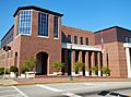
Troup County Courthouse and Government Center in LaGrange, April 2012.
|
|||
|
|||

Location within the U.S. state of Georgia
|
|||
 Georgia's location within the U.S. |
|||
| Country | |||
| State | |||
| Founded | June 9, 1826 | ||
| Named for | George Troup | ||
| Seat | LaGrange | ||
| Largest city | LaGrange | ||
| Area | |||
| • Total | 446 sq mi (1,160 km2) | ||
| • Land | 414 sq mi (1,070 km2) | ||
| • Water | 32 sq mi (80 km2) 7.2%% | ||
| Population
(2020)
|
|||
| • Total | 69,426 | ||
| • Estimate
(2023)
|
70,742 |
||
| • Density | 155.66/sq mi (60.10/km2) | ||
| Time zone | UTC−5 (Eastern) | ||
| • Summer (DST) | UTC−4 (EDT) | ||
| Congressional district | 3rd | ||


Troup County (say it like "TROOP") is a county in the western-central part of Georgia. In 2020, about 69,426 people lived there. The main city and county seat (where the county government is) is LaGrange. Troup County is part of the LaGrange area, which is a smaller city area. It's also included in the larger Atlanta-Athens-Clarke County-Sandy Springs region.
Contents
History of Troup County
For thousands of years, different groups of indigenous peoples (the first people to live in an area) lived in what is now Troup County. Later, the Creek people controlled this land.
In 1825, the Creek people signed a treaty (a formal agreement) with the United States. In this treaty, they gave up land for several new counties, including Troup County. The Georgia General Assembly (Georgia's law-making group) officially created the county boundaries on June 9, 1826. The county was named on December 14, 1826.
Troup County is named after George Troup. He was the 34th governor of Georgia. He also served as a representative and a senator in the U.S. government.
In the years before the American Civil War (called the antebellum era), this area was used to grow a lot of cotton. By 1860, Troup County was one of the wealthiest counties in Georgia. It also had a large number of enslaved people.
- In 1860, the county had 6,223 white people and 10,002 enslaved people.
- By 1870, after the Civil War, the number of white people grew slightly to 6,408. The number of Black people (who were now free) increased to 11,224.
In the late 1800s, people in LaGrange started building cotton mills. These factories made cloth from cotton. Textile manufacturing became a very important part of the economy. This continued until the late 20th century, when many textile factories moved to other countries where labor was cheaper.
Changes in the 20th Century
In the first half of the 1900s, many Black people left Georgia and other Southern states. This was part of a big movement called the Great Migration. They were looking for better jobs because machines were doing more farm work. They also wanted more opportunities and to escape unfair laws and treatment in the South.
After the Voting Rights Act of 1965 was passed, Black people in Troup County and across the South slowly gained back their right to vote. They could also take part in politics more easily.
As of 2015, the official historian for Troup County is Forrest Clark Johnson, III. He has written several books about the history of the county. He used to be a teacher in the county's school system.
Geography of Troup County
Troup County covers about 446 square miles. Most of this (414 square miles) is land. The other 32 square miles (about 7.2%) is water.
All of Troup County is located in the Middle Chattahoochee River area. This area is part of a larger river system called the ACF River Basin.
Main Roads
Many important roads run through Troup County:
 Interstate 85
 Interstate 185
 U.S. Route 27
 U.S. Route 29
 State Route 1
 State Route 14
 State Route 14 Connector
 State Route 14 Spur
 State Route 18
 State Route 54
 State Route 100
 State Route 103
 State Route 109
 State Route 219
 State Route 403 (this is another name for I-85)
 State Route 411 (this is another name for I-185)
Neighboring Counties
Troup County shares borders with these other counties:
- Coweta County (to the northeast)
- Meriwether County (to the east)
- Harris County (to the south)
- Chambers County, Alabama (to the southwest)
- Randolph County, Alabama (to the northwest)
- Heard County (to the north)
Towns and Communities
Here are some of the towns and communities in Troup County:
- Harrisonville
- Hogansville
- LaGrange
- Long Cane
- Mountville
- West Point
- Woodfield
- Gray Hill
Population Over Time
The number of people living in Troup County has changed a lot over the years.
- In 1830, there were about 5,799 people.
- By 1900, the population grew to 24,002.
- In 1950, it was 49,841.
- In 2020, the population was 69,426.
- Estimates for 2023 show about 70,742 people living there.
The county is made up of people from many different backgrounds:
- About 54.88% are White (not Hispanic).
- About 34.8% are Black or African American.
- About 2.32% are Asian.
- About 4.26% are Hispanic or Latino.
- Other groups make up the rest of the population.
See also
 In Spanish: Condado de Troup para niños
Images for kids
-
Troup County Courthouse and Government Center in LaGrange, April 2012.
