Harris County, Georgia facts for kids
Quick facts for kids
Harris County
|
|
|---|---|

County courthouse in Hamilton
|
|

Location within the U.S. state of Georgia
|
|
 Georgia's location within the U.S. |
|
| Country | |
| State | |
| Founded | December 14, 1827 |
| Named for | Charles Harris |
| Seat | Hamilton |
| Largest city | Pine Mountain |
| Area | |
| • Total | 473 sq mi (1,230 km2) |
| • Land | 464 sq mi (1,200 km2) |
| • Water | 9.1 sq mi (24 km2) 1.9%% |
| Population
(2020)
|
|
| • Total | 34,668 |
| • Estimate
(2023)
|
36,654 |
| • Density | 73.29/sq mi (28.299/km2) |
| Time zone | UTC−5 (Eastern) |
| • Summer (DST) | UTC−4 (EDT) |
| Congressional district | 3rd |
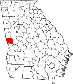
Harris County is a county located in the western part of Georgia. Its western edge touches the state of Alabama, along the Chattahoochee River. In 2020, about 34,668 people lived here.
The main town, or county seat, is Hamilton. The biggest city is Pine Mountain. This city is a popular place to visit and is home to the Franklin D. Roosevelt State Park. This park is the largest state park in Georgia.
Harris County was created on December 14, 1827. It was named after Charles Harris, who was a judge and lawyer in Georgia. Many families from the nearby city of Columbus have moved to Harris County. This has made Harris County one of the wealthiest counties in Georgia. It is the wealthiest county in Georgia outside of the Atlanta area.
Contents
History of Harris County
European settlers came to Harris County after the Creek people, who were the native people, were moved away by the government. In the past, parts of the county had large cotton farms called plantations. Many enslaved people were brought from other parts of the United States to work on these farms.
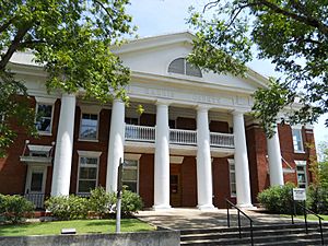
The County courthouse was finished in 1906. It was designed by Edward Columbus Hosford.
In the late 1800s and early 1900s, some people in the mountain areas of the county made homemade alcohol. This was a way for them to earn money. Today, Harris County is part of the Columbus, Georgia metropolitan area. This area has many industries and a strong economy.
Geography of Harris County
Harris County covers about 473 square miles. Most of this area, about 464 square miles, is land. The remaining 9.1 square miles, which is about 1.9%, is water.
Most of the county is in the Middle Chattahoochee River-Lake Harding area. This area is part of a larger river system called the ACF River Basin. A small part of the county's southeastern border is in a different section of the same river basin.
Major roads
 Interstate 85
 Interstate 185
 U.S. Route 27
 U.S. Route 27 Alternate
 State Route 1
 State Route 18
 State Route 36
 State Route 85
 State Route 85 Alternate
 State Route 103
 State Route 116
 State Route 190
 State Route 208
 State Route 219
 State Route 315
 State Route 354
 State Route 403 (this is another name for I-85)
 State Route 411 (this is another name for I-185)
Neighboring counties
- Troup County (north)
- Meriwether County (northeast)
- Talbot County (east)
- Muscogee County (south)
- Lee County, Alabama (southwest)
- Chambers County, Alabama (northwest)
Communities in Harris County
Cities
- Hamilton - This is the county seat.
- Shiloh
- West Point
Towns
Unincorporated communities
- Cataula
- Ellerslie
- Fortson
- Midland
- Mountain Hill
- Pine Mountain Valley
- Piney Grove
- Rehobeth
- Ridgeway
- Whitesville
Population Information
| Historical population | |||
|---|---|---|---|
| Census | Pop. | %± | |
| 1830 | 5,105 | — | |
| 1840 | 13,933 | 172.9% | |
| 1850 | 14,721 | 5.7% | |
| 1860 | 13,736 | −6.7% | |
| 1870 | 13,284 | −3.3% | |
| 1880 | 15,758 | 18.6% | |
| 1890 | 16,797 | 6.6% | |
| 1900 | 18,009 | 7.2% | |
| 1910 | 17,886 | −0.7% | |
| 1920 | 15,775 | −11.8% | |
| 1930 | 11,140 | −29.4% | |
| 1940 | 11,428 | 2.6% | |
| 1950 | 11,265 | −1.4% | |
| 1960 | 11,167 | −0.9% | |
| 1970 | 11,520 | 3.2% | |
| 1980 | 15,464 | 34.2% | |
| 1990 | 17,788 | 15.0% | |
| 2000 | 23,695 | 33.2% | |
| 2010 | 32,024 | 35.2% | |
| 2020 | 34,668 | 8.3% | |
| 2023 (est.) | 36,654 | 14.5% | |
| U.S. Decennial Census 1790-1880 1890-1910 1920-1930 1930-1940 1940-1950 1960-1980 1980-2000 2010 |
|||
This table shows the different groups of people living in Harris County in 2020:
| Race | Number of People | Percentage |
|---|---|---|
| White (not Hispanic) | 25,925 | 74.78% |
| Black or African American (not Hispanic) | 5,170 | 14.91% |
| Native American | 101 | 0.29% |
| Asian | 388 | 1.12% |
| Pacific Islander | 21 | 0.06% |
| Other/Mixed | 1,646 | 4.75% |
| Hispanic or Latino | 1,417 | 4.09% |
In 2020, there were 34,668 people living in Harris County. These people lived in 12,156 households, and 9,581 of these were families.
Education in Harris County
The Harris County School District manages schools from preschool all the way to 12th grade. The district has four elementary schools, one intermediate school, one middle school, and one high school.
The main office for the school district is in Hamilton. There are 274 full-time teachers who teach over 4,411 students across the seven schools.
- Mulberry Creek Elementary School (Cataula)
- New Mountain Hill Elementary School (Fortson)
- Park Elementary School (Hamilton)
- Pine Ridge Elementary School (Ellerslie)
- Creekside Intermediate School (for grades 5–6) (Cataula)
- Harris County Carver Middle School (Hamilton)
- Harris County High School (Hamilton)
Notable People from Harris County
- Reuben J. Crews - He was a colonel in the Georgia Militia and the father of C.C. Crews.
- Josh Pate - He hosts a popular podcast about college football for 247Sports.
- Benjamin Franklin White - He was a clerk for the court in Harris County and the mayor of Whitesville. He also put together a famous songbook called The Sacred Harp.
See also
 In Spanish: Condado de Harris (Georgia) para niños
 | Valerie Thomas |
 | Frederick McKinley Jones |
 | George Edward Alcorn Jr. |
 | Thomas Mensah |


