Muscogee County, Georgia facts for kids
Quick facts for kids
Muscogee County
|
|
|---|---|

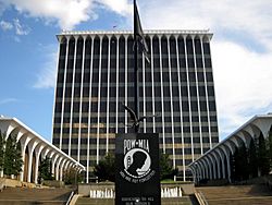
Columbus Consolidated Government Center
|
|

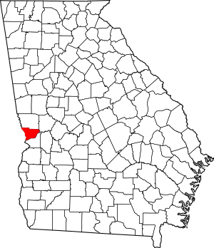
Location within the U.S. state of Georgia
|
|
 Georgia's location within the U.S. |
|
| Country | |
| State | |
| Founded | June 9, 1826 |
| Named for | Muscogee people |
| Seat | Columbus |
| Largest city | Columbus |
| Area | |
| • Total | 221 sq mi (570 km2) |
| • Land | 216 sq mi (560 km2) |
| • Water | 4.6 sq mi (12 km2) 2.1%% |
| Population
(2020)
|
|
| • Total | 206,922 |
| • Density | 958/sq mi (370/km2) |
| Time zone | UTC−5 (Eastern) |
| • Summer (DST) | UTC−4 (EDT) |
| Congressional districts | 2nd, 3rd |
Muscogee County is a county located in the middle of Georgia's western border. It is named after the Muscogee people, who originally lived on this land. The Chattahoochee River forms its western border with Alabama.
In 2020, about 206,922 people lived here. The county's main city and only city is Columbus. Since 1971, Muscogee County and Columbus have been joined together as one consolidated city-county.
Muscogee County is part of the larger Columbus, GA–AL, metropolitan statistical area.
The only other city that used to be in the county was Bibb City. This was a "company town" that closed down in 2000 after its factory shut. Fort Moore (which used to be called Fort Benning) is a big Army base. It covers almost a quarter of the county and helps the local economy a lot.
Contents
History of Muscogee County
This area was home to different groups of indigenous peoples for thousands of years. When Europeans first arrived, the Creek people lived here.
In 1825, a few chiefs from the Creek people signed a deal called the Treaty of Indian Springs. This deal gave away land for what would become Lee, Muscogee, Troup, Coweta, and Carroll counties. However, most of the Creek Nation said this deal was not legal because it didn't represent everyone.
The U.S. government didn't approve that treaty. So, the next year, they made another deal with the Creek people. The Creek still had to give up a lot of land because of pressure from Georgia and U.S. officials.
The boundaries for these new counties were set on June 9, 1826. But they weren't named until December 14, 1826. Early on, the county was used for growing cotton on large farms called plantations. Many areas, known as the Black Belt because of their rich soil, had a lot of enslaved African Americans working on these plantations.
Muscogee County was named by American Indians for the native Muscogee or Creek people. Over time, parts of the original large county were used to create other nearby counties. For example, Harris County was formed to the north in 1827, and Chattahoochee County was formed to the south in 1854.
Geography of Muscogee County
The U.S. Census Bureau says the county covers about 221 square miles. Most of this (216 square miles) is land, and a small part (4.6 square miles) is water.
The county sits on the fall line. This is where the flat Atlantic coastal plain meets the hilly Piedmont region. Because of this, the northern part of the county has more hills than the southern part. The Fall Line Freeway also runs through the northern part of the county.
Most of Muscogee County is in the Middle Chattahoochee River-Walter F. George Lake area. This is part of the larger ACF River Basin (Apalachicola-Chattahoochee-Flint River Basin). A small part in the northwest is in the Middle Chattahoochee River-Lake Harding area of the same river basin.
Major Roads
 Interstate 14 (An extension is planned)
 Interstate 185
 U.S. Route 27
 U.S. Route 27 Alternate
 U.S. Route 80
 U.S. Route 280
 State Route 1
 State Route 22
 State Route 22 Connector
 State Route 22 Spur
 State Route 85
 State Route 219
 State Route 411 (This is another name for I-185)
 State Route 520
 State Route 540 (Fall Line Freeway)
Neighboring Counties
- Harris County (north)
- Talbot County (northeast)
- Chattahoochee County (south)
- Russell County, Alabama (southwest)
- Lee County, Alabama (west)
Communities in Muscogee County
Cities
- Columbus (This is the county seat)
Former Cities
Unincorporated Areas
- Fort Moore (This is a military base)
Population and People
| Historical population | |||
|---|---|---|---|
| Census | Pop. | %± | |
| 1830 | 3,508 | — | |
| 1840 | 11,699 | 233.5% | |
| 1850 | 18,578 | 58.8% | |
| 1860 | 16,584 | −10.7% | |
| 1870 | 16,663 | 0.5% | |
| 1880 | 19,322 | 16.0% | |
| 1890 | 27,761 | 43.7% | |
| 1900 | 29,836 | 7.5% | |
| 1910 | 36,227 | 21.4% | |
| 1920 | 44,195 | 22.0% | |
| 1930 | 57,558 | 30.2% | |
| 1940 | 75,494 | 31.2% | |
| 1950 | 118,028 | 56.3% | |
| 1960 | 158,623 | 34.4% | |
| 1970 | 167,377 | 5.5% | |
| 1980 | 170,108 | 1.6% | |
| 1990 | 179,278 | 5.4% | |
| 2000 | 186,291 | 3.9% | |
| 2010 | 189,885 | 1.9% | |
| 2020 | 206,922 | 9.0% | |
| 2023 (est.) | 201,877 | 6.3% | |
| U.S. Decennial Census 1790-1880 1890-1910 1920-1930 1930-1940 1940-1950 1960-1980 1980-2000 2010 |
|||
| Race | Num. | Perc. |
|---|---|---|
| White (not Hispanic) | 79,083 | 38.22% |
| Black or African American (not Hispanic) | 94,701 | 45.77% |
| Native American | 488 | 0.24% |
| Asian | 5,546 | 2.68% |
| Pacific Islander | 517 | 0.25% |
| Other/mixed | 10,074 | 4.87% |
| Hispanic or Latino | 16,513 | 7.98% |
In 2000, there were 186,291 people living in the county. There were about 69,819 households and 47,686 families. The population density was about 861 people per square mile.
By 2010, the population grew to 189,885 people. There were 74,081 households and 47,742 families. In 2020, the population reached 206,922 people. There were 73,134 households and 45,689 families.
Education in Muscogee County
Colleges and Universities
Public Colleges
- Columbus State University
- Columbus Technical College
- Troy University (main campus is in Alabama)
Private Colleges
- Rivertown School of Beauty
- Southeastern Beauty School
- Meadows Junior College
- University of Phoenix
Schools for Kids (K-12)
Public Schools
The Muscogee County School District serves all students from kindergarten to 12th grade, except for those living at Fort Moore. Children at Fort Moore go to special schools run by the Department of Defense Education Activity (DoDEA) for grades K-8. However, high school students from Fort Moore attend public high schools in the county.
Private and Religious Schools
- Brookstone School (K-12)
- Calvary Christian School (Christian, K-12)
- Edgewood Christian School (Baptist, K-12)
- Grace Christian School (Christian, K-12)
- Hallie Turner Private School (9-12)
- Kip Christian Academy (Christian, K-8)
- New Bethel Christian Academy (Seventh-day Adventist, K-8)
- Our Lady of Lourdes School (Catholic, K-8)
- Our Redeemer Christian Academy (Christian, K-12)
- Pinehurst Christian School (Baptist, K-8)
- St. Anne‒Pacelli Catholic School (Catholic, K-12)
- St. Luke School (Christian, K-8)
- Victory Academy (K-8)
- Westminster Christian School (Christian, K-8)
- Wynnbrook Christian School (Baptist, K-12)
Homeschooling
In Georgia, parents can teach their children at home. The law says that homeschooling must include basic subjects like reading, language arts, math, social studies, and science.
See also
 In Spanish: Condado de Muscogee para niños
 | Aurelia Browder |
 | Nannie Helen Burroughs |
 | Michelle Alexander |

