Muskogee County, Oklahoma facts for kids
Quick facts for kids
Muskogee County
|
|
|---|---|

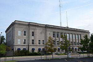
Muskogee County Courthouse in September 2015
|
|

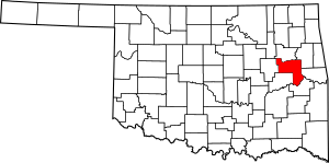
Location within the U.S. state of Oklahoma
|
|
 Oklahoma's location within the U.S. |
|
| Country | |
| State | |
| Founded | 1907 |
| Named for | Muscogee Nation |
| Seat | Muskogee |
| Largest city | Muskogee |
| Area | |
| • Total | 840 sq mi (2,200 km2) |
| • Land | 810 sq mi (2,100 km2) |
| • Water | 29 sq mi (80 km2) 3.5%% |
| Population
(2020)
|
|
| • Total | 66,339 |
| • Density | 79.0/sq mi (30.49/km2) |
| Congressional district | 2nd |
Muskogee County is a county in the state of Oklahoma, USA. In 2020, about 66,339 people lived here. The main city and county seat is Muskogee. Both the county and the city are named after the Muscogee (Creek) Nation. The name was officially changed to Muskogee by the post office in 1900. Muskogee County is part of a larger area that includes Tulsa.
Contents
History
Early People and Explorers
Archaeologists have found signs that people lived in this area a very long time ago, even before 6,000 B.C. More studies have been done on the "Mound Builders." These people lived here between A.D. 300 and 1200.
One of the first Europeans to visit this area was Jean Baptiste Bénard de la Harpe. He was a French explorer and trader. In 1719, he found a Wichita village here. By the late 1700s, the Osage people had taken over the area. They used it for hunting.
Forts and Settlements
Auguste Pierre Chouteau and other fur traders started a settlement at a place called the Three Forks. In the early 1800s, Cherokee and Choctaw hunting groups often fought with the Osage. To stop these fights, the U.S. Army built Fort Gibson in 1824. It was located on the Grand River. The town of Fort Gibson, which grew near the fort, claims to be the oldest town in Oklahoma.
During the U.S. Civil War, Confederate soldiers built Fort Davis. It was across the Arkansas River from Fort Gibson. In 1862, Federal troops attacked and destroyed Fort Davis. This drove the Confederates out of the area. However, some smaller battles happened later in the war.
County Formation and Railroads
Muskogee County was officially formed when Oklahoma became a state in 1907. It was made from parts of the Muskogee District of the Creek Nation and the Canadian and Illinois Districts of the Cherokee Nation. A post office named Muscogee opened in 1872. The spelling was changed to Muskogee in 1900.
After the Civil War, the Five Civilized Tribes (including the Creeks) made new agreements with the government. They gave back some of their land. They also allowed railroads to build lines through their territory. The Missouri, Kansas and Texas Railway (called Katy) built a line near the Three Forks. They planned a train station at Fort Davis. But the land was not good, so they moved the station south and named it Muscogee. They also started the town of Oktaha nearby.
Other railroads were built later. These included the Kansas and Arkansas Valley Railway and the Midland Valley Railroad.
Government Offices
In 1874, the federal government brought all the offices for the Five Civilized Tribes together. This "Union Agency" was just west of Muscogee. In 1889, a federal court was created in Muscogee. The Dawes Commission, which dealt with Native American land, also set up its main office there in 1894.
Geography
Muskogee County covers about 840 square miles. About 810 square miles are land, and 29 square miles (3.5%) are water.
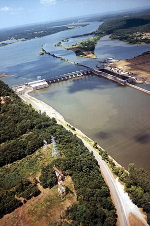
The western part of the county has flat prairie grasslands. The eastern part has hills called the Cookson Hills. These hills are on the edge of the Ozark Mountains. The Arkansas, Verdigris, and Grand rivers all meet in the county. This area is known as "Three Forks." Webbers Falls Lake on the Arkansas River is also partly in the county.
Major Highways
Neighboring Counties
- Wagoner County (north)
- Cherokee County (northeast)
- Sequoyah County (east)
- Haskell County (southeast)
- McIntosh County (southwest)
- Okmulgee County (west)
Protected Areas
- Sequoyah National Wildlife Refuge (part of it is in the county)
Population Information
| Historical population | |||
|---|---|---|---|
| Census | Pop. | %± | |
| 1910 | 52,743 | — | |
| 1920 | 61,710 | 17.0% | |
| 1930 | 66,424 | 7.6% | |
| 1940 | 65,914 | −0.8% | |
| 1950 | 65,573 | −0.5% | |
| 1960 | 61,866 | −5.7% | |
| 1970 | 59,542 | −3.8% | |
| 1980 | 66,939 | 12.4% | |
| 1990 | 68,078 | 1.7% | |
| 2000 | 69,451 | 2.0% | |
| 2010 | 70,990 | 2.2% | |
| 2020 | 66,339 | −6.6% | |
| U.S. Decennial Census 1790-1960 1900-1990 1990-2000 2010 |
|||
In 2020, the county's population was 66,339 people.
In 2010, there were 70,990 people living in Muskogee County.
- About 59.8% were White.
- About 17.5% were Native American.
- About 11.3% were Black or African American.
- About 0.6% were Asian.
- About 2.6% were of some other race.
- About 8.2% were of two or more races.
- About 5.2% were Hispanic or Latino (of any race).
Economy
When Oklahoma became a state, the economy of Muskogee County was mostly about farming and raising animals. Farmers grew corn, cotton, and wheat. Businesses that helped farmers included cotton gins and grain mills. Cotton farming went down a lot during the Great Depression. It was replaced by crops like soybeans, wheat, and other grains. After World War II, growing vegetables became important. This led to factories that canned and processed food.
Other jobs came from oil, gas, and coal. But these industries were not as big as in other places. Digging for sand and gravel, and making bricks and glass, also provided many jobs. A company called O. W. Coburn built a large optical business. The Buddrus family started Acme Engineering, and the Rooney family founded Manhattan Construction. Government jobs, especially in education and helping veterans, have also been important. Today, light manufacturing, health care, and social services provide many jobs. The town of Taft has two state correctional facilities.
Steamboats used to travel on the Arkansas River. In 1971, the McClellan-Kerr Arkansas River Navigation System opened. This allowed commercial boats to travel on the Arkansas and Verdigris rivers all year. This helped the Port of Muskogee grow.
Education
Education was very important after the Civil War. Churches, private groups, and the Cherokee and Creek nations started schools. Higher education became available after 1880. Bacone College, Oklahoma's oldest college, started as Indian University. It moved to Muskogee County in 1885.
Evangel Mission was a school for Creek freedmen in the 1880s. Today, its building houses the Five Civilized Tribes Museum in Muskogee. A school for visually impaired people opened in Fort Gibson in 1898. It later moved to Muskogee and became the Oklahoma School for the Blind. Minerva Home, a girls' school in Muskogee, became Henry Kendall College in 1894. This college later moved to Tulsa and became the University of Tulsa in 1920. Northeastern State University opened a campus in Muskogee in 1994.
K-12 School Districts
- Braggs Public Schools
- Checotah Public Schools
- Fort Gibson Public Schools
- Gore Public Schools
- Haskell Public Schools
- Hilldale Public Schools
- Midway Public Schools
- Muskogee Public Schools
- Oktaha Public Schools
- Porum Public Schools
- Wainwright Public School
- Warner Public Schools
- Webbers Falls Public Schools
State-Operated Schools
- Oklahoma School for the Blind (Muskogee)
Communities
Cities
- Muskogee (county seat)
Towns
Census-Designated Places
- Briartown
- Keefton
- Norwood (mostly in Cherokee County)
- River Bottom
- Sand Hill
- Simms
- Sour John
Other Unincorporated Place
Notable People
- Tom Coburn (born 1948): Lived in Muskogee. He served in the U.S. House of Representatives and later as a U.S. Senator for Oklahoma.
- Drew Edmondson (born 1946): Was the attorney general for Oklahoma.
- Edmond Edmondson (1919–1990): Served in the U.S. Congress for the district that includes Muskogee County.
- James Howard Edmondson (1925–1971): Born in Muskogee. He was the governor of Oklahoma and later a U.S. Senator.
- Charles N. Haskell (1860–1933): Moved to Muskogee in 1901. He became a leader and was Oklahoma's first governor in 1907.
- Robert L. Owen (1856–1947): A Cherokee who worked for the U.S. government in Muskogee. In 1907, he became one of Oklahoma's first U.S. senators.
- Pleasant Porter (1840–1907): Was the main chief of the Creek Nation. He helped make important land agreements.
- Alexander Posey (1873–1908): A Creek poet and newspaper editor in Muskogee. He helped write much of the state's constitution.
- Alice M. Robertson (1854–1931): The first woman to be a postmaster for a major U.S. post office. In 1920, she was elected to the U.S. House of Representatives. She was the second woman in the U.S. to hold a seat in Congress.
- Belle Starr (1848–1899): An American outlaw who lived in the Cookson Hills in eastern Muskogee County.
- Mike Synar (1950–1996): Served in the U.S. Congress.
Historic Places (NRHP sites)
Many places in Muskogee County are listed on the National Register of Historic Places. This means they are important historical sites.
|
|
See also
 In Spanish: Condado de Muskogee para niños
 | Shirley Ann Jackson |
 | Garett Morgan |
 | J. Ernest Wilkins Jr. |
 | Elijah McCoy |


