Haskell County, Oklahoma facts for kids
Quick facts for kids
Haskell County
|
|
|---|---|

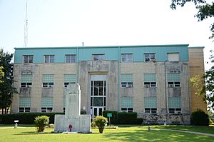
Haskell County Courthouse in Stigler
|
|

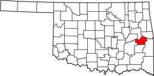
Location within the U.S. state of Oklahoma
|
|
 Oklahoma's location within the U.S. |
|
| Country | |
| State | |
| Founded | 1907 |
| Named for | Charles N. Haskell |
| Seat | Stigler |
| Largest city | Stigler |
| Area | |
| • Total | 625 sq mi (1,620 km2) |
| • Land | 577 sq mi (1,490 km2) |
| • Water | 49 sq mi (130 km2) 7.8%% |
| Population
(2020)
|
|
| • Total | 11,561 |
| • Density | 18.498/sq mi (7.142/km2) |
| Time zone | UTC−6 (Central) |
| • Summer (DST) | UTC−5 (CDT) |
| Congressional district | 2nd |
Haskell County is a county in the southeastern part of Oklahoma, a state in the United States. In 2020, about 11,561 people lived there. The main town and county seat is Stigler. The county is named after Charles N. Haskell, who was the first governor of Oklahoma.
Contents
History of Haskell County
Haskell County was formed in 1907 when Oklahoma became a state. Most of its land came from an area called Sans Bois County, which was part of the Choctaw Nation in what was then called Indian Territory.
In 1908, people in the county voted for Stigler to be their county seat. This meant Stigler became the main town where the county government offices are located.
In the early 1900s, coal mining was very important here. It created many jobs and led to railroads being built. A company even built over 400 houses for miners in the towns of McCurtain and Chant. Sadly, in 1912, a big explosion happened in a coal mine in McCurtain. Seventy-three miners died, and the company went out of business. After this disaster and a drop in demand for coal, underground mining stopped.
However, strip mining (where coal is dug from the surface) continued. The Lone Star Steel Company became a major coal producer. Between 1950 and 1980, Haskell County produced 20% of all coal in Oklahoma.
Farming was also very important early on, especially cotton, corn, and oats. But when cotton prices dropped and the Great Depression hit, many people left the county. Ranching (raising livestock like cattle) then became more important than farming. By 1964, livestock brought in about 70% of the county's money.
Geography of Haskell County
Haskell County covers about 625 square miles. Most of this is land (577 square miles), but a good portion is water (49 square miles). The southern part of the county has the Sans Bois Mountains, where the land can be between 500 and 1500 feet high.
The large amount of water comes from Eufaula Lake and the Robert S. Kerr Reservoir. The South Canadian River forms the northern border of the county. It flows into the Arkansas River at the Robert S. Kerr Reservoir. The Arkansas River then forms the northeastern border.
Major roads
Neighboring counties
- Muskogee County (north)
- Sequoyah County (northeast)
- Le Flore County (east)
- Latimer County (south)
- Pittsburg County (west)
- McIntosh County (northwest)
Protected natural areas
- Sequoyah National Wildlife Refuge (part of it is in Haskell County)
People of Haskell County (Demographics)
| Historical population | |||
|---|---|---|---|
| Census | Pop. | %± | |
| 1910 | 18,875 | — | |
| 1920 | 19,397 | 2.8% | |
| 1930 | 16,216 | −16.4% | |
| 1940 | 17,324 | 6.8% | |
| 1950 | 13,313 | −23.2% | |
| 1960 | 9,121 | −31.5% | |
| 1970 | 9,578 | 5.0% | |
| 1980 | 11,010 | 15.0% | |
| 1990 | 10,940 | −0.6% | |
| 2000 | 11,792 | 7.8% | |
| 2010 | 12,769 | 8.3% | |
| 2020 | 11,561 | −9.5% | |
| U.S. Decennial Census 1790-1960 1900-1990 1990-2000 2010 |
|||
In 2010, there were 12,769 people living in Haskell County. Most people were White (74.9%), and a good number were Native American (15.9%). Some people were also Asian, Black, or of other races. About 7% of the population had two or more racial backgrounds. Around 3.3% of the people were Hispanic or Latino.
Towns and Communities
City
- Stigler (This is the county seat)
Towns
Census-designated places
These are special areas that are like towns but are not officially incorporated.
Haskell County Courthouse
The Haskell County Courthouse is in Stigler. It became well-known because it had marble statues of the Ten Commandments and the Mayflower Compact on its front lawn.
A federal court decided that these statues needed to be moved. The court ruled that placing them on public land at the courthouse was not allowed. After this decision, the marble statue was moved about 600 feet away to private property. This way, people can still see it on the main street if they wish.
Historic Places
Several places in Haskell County are listed on the National Register of Historic Places. This means they are important historical sites that are protected.
- Cotton Storage House, Kinta
- Haskell County Courthouse, Stigler
- Kinta High School, Kinta
- McCurtain, Edmund, House, Kinta
- McCurtain, Green, House, Kinta
- Mule Creek Site, Stigler
- Otter Creek Archeological Site, Keota
- Scott Store, Kinta
- Stigler School Gymnasium--Auditorium, Stigler
- Tamaha Jail and Ferry Landing, Stigler
See also
 In Spanish: Condado de Haskell (Oklahoma) para niños
 | Delilah Pierce |
 | Gordon Parks |
 | Augusta Savage |
 | Charles Ethan Porter |

