Latimer County, Oklahoma facts for kids
Quick facts for kids
Latimer County
|
|
|---|---|

|
|

Location within the U.S. state of Oklahoma
|
|
 Oklahoma's location within the U.S. |
|
| Country | |
| State | |
| Founded | 1907 |
| Named for | James L. Latimer |
| Seat | Wilburton |
| Largest city | Wilburton |
| Area | |
| • Total | 729 sq mi (1,890 km2) |
| • Land | 722 sq mi (1,870 km2) |
| • Water | 7.0 sq mi (18 km2) 0.95%% |
| Population
(2020)
|
|
| • Total | 9,444 |
| • Density | 12.955/sq mi (5.002/km2) |
| Time zone | UTC−6 (Central) |
| • Summer (DST) | UTC−5 (CDT) |
| Congressional district | 2nd |
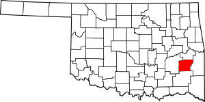
Latimer County is a county in the southeastern part of Oklahoma. Its main town and county seat is Wilburton. In 2020, about 9,444 people lived there.
The county was created in 1907 when Oklahoma became a state. It was named after James L. Latimer. He was a delegate from Wilburton who helped write Oklahoma's first constitution in 1906. Before Oklahoma became a state, this area was part of the Choctaw Nation.
Contents
History
For over 3,500 years, different groups of Native American people lived in this area. The most recent of these groups built large earth mounds. These were part of the Mississippian culture. Scientists have found old tools and items from the Archaic, Woodland, and Mississippian cultures here. These ancient people were the ancestors of the Caddo Nation. The Caddo were a group of tribes that lived in Texas, Arkansas, and Louisiana.
In the 1970s, a place called the McCutchan-McLaughlin site was explored. This site taught us a lot about the Fourche Maline culture. These people lived here from about 300 BCE to 800 CE. They were hunter-gatherers, meaning they hunted animals and gathered plants for food. They were healthier than later groups who grew corn. But they often fought battles. Many bodies were found in mass graves, showing they were killed by arrows or spears. This important site is now on the National Register of Historic Places.
In 1831, the U.S. government moved the Choctaw people from their homes in the Southeast. This area became part of the Choctaw Nation in what was called the Indian Territory. When Oklahoma became a state, Latimer County's borders were set using straight lines. But the Choctaw Nation used natural landmarks like mountains and rivers for their county borders. The land that is now Latimer County was once where three major Choctaw districts met. These were the Apukshunubbee, Moshulatubbee, and Pushmataha Districts.
In 1858, the Butterfield Overland Mail route passed through this area. This was a stagecoach service that delivered mail and passengers. It had stops near present-day Hughes, Red Oak, Lutie, and Higgins.
Coal mining became very important here. Railroads were built to carry the coal to markets. The main coal mining areas were in the mountains to the north. Many coal companies started in the late 1800s and early 1900s. By 1890, a railroad line was built from Wister to McAlester. Another line connected North McAlester to Wilburton in 1904.
Before Oklahoma became a state, the Dawes Act changed how Native American lands were owned. The Choctaw Nation's shared lands were divided up. Each Native American family received a piece of land. This was meant to encourage them to farm like European Americans. The Choctaw people lost most of their land this way. The government sold any leftover land, mostly to non-Native people. The tribal governments were also ended. Later, a Supreme Court case in 2020, called McGirt v. Oklahoma, said that much of eastern Oklahoma is still Native American land. This means that serious crimes involving Native Americans on these lands are handled by tribal courts and federal courts, not Oklahoma's state courts.
By 1912, Latimer County had 27 coal mines. About 3,000 miners dug up 5,000 tons of coal every day. Most miners were white, but African Americans, European immigrants, and Mexicans also worked in the mines.
However, the coal industry soon collapsed. This happened because of worker strikes, new fuels like oil, and the Great Depression. From 1920 to 1930, about 2,000 people left the county to find work elsewhere. By 1932, only one mine was still open. Many mining towns lost almost half their people. At one point, most people in the county relied on government help. President Franklin D. Roosevelt started programs to create jobs and build new things. These projects included the Wilburton Municipal Airport, schools, and paved roads. The Civilian Conservation Corps (CCC) also helped develop Robbers Cave State Park.
In 1933, veterans from the Spanish-American War started a community called Veterans Colony. They bought land together to build cabins and grow their own food. Later, veterans from all wars could join. Veterans Colony is still active today.
Geography
Latimer County covers about 729 square miles. Most of this is land (722 square miles), and a small part is water (7 square miles).
The Sans Bois Mountains are along the northern border of the county. The Winding Stair Mountains are in the southern part. Several creeks, like Fourche Maline and Brazil creeks, flow north into the Poteau River. This river then flows into the Arkansas River. Buffalo and Gaines Creeks flow south into the Kiamichi River, which is part of the Red River.
Major highways
- U.S. Highway 270
- State Highway 1
- State Highway 2
- State Highway 63
- State Highway 82
Adjacent counties
- Haskell County (north)
- Le Flore County (east)
- Pushmataha County (south)
- Pittsburg County (west)
Demographics
| Historical population | |||
|---|---|---|---|
| Census | Pop. | %± | |
| 1910 | 11,321 | — | |
| 1920 | 13,866 | 22.5% | |
| 1930 | 11,184 | −19.3% | |
| 1940 | 12,380 | 10.7% | |
| 1950 | 9,690 | −21.7% | |
| 1960 | 7,738 | −20.1% | |
| 1970 | 8,601 | 11.2% | |
| 1980 | 9,840 | 14.4% | |
| 1990 | 10,333 | 5.0% | |
| 2000 | 10,692 | 3.5% | |
| 2010 | 11,154 | 4.3% | |
| 2020 | 9,444 | −15.3% | |
| U.S. Decennial Census 1790-1960 1900-1990 1990-2000 2010 |
|||
In 2000, there were about 10,692 people living in Latimer County. About 73% were White, and about 19% were Native American. People from many different backgrounds live here.
Economy
Coal mining was the most important industry in Latimer County. Mines were operating by 1895. By 1912, the county had 27 mines. They produced thousands of tons of coal each day. But the coal industry declined in the 1920s. This was due to worker problems, competition from oil, and the Great Depression. By 1933, only one mine was still open.
Farming was mostly for selling vegetables to the mining towns. Cotton, corn, and cattle were also important crops. After the coal industry collapsed, the main jobs became raising cattle, cutting timber, and producing oil and gas.
Education
In 1909, the state opened the Oklahoma School of Mines and Metallurgy in Wilburton. This school is now called Eastern Oklahoma State College. It is a two-year college.
Communities
City
- Wilburton (county seat)
Towns
- Fanshawe (mostly in Le Flore County)
- Red Oak
Census-designated places
NRHP sites
Many places in Latimer County are listed on the National Register of Historic Places. This means they are important historical sites.
|
|
See also
 In Spanish: Condado de Latimer para niños
 | Bessie Coleman |
 | Spann Watson |
 | Jill E. Brown |
 | Sherman W. White |


