Pittsburg County, Oklahoma facts for kids
Quick facts for kids
Pittsburg County
|
|
|---|---|

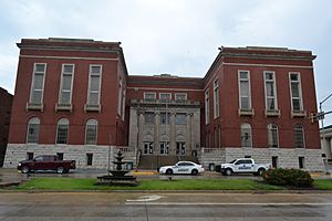
Pittsburg County Courthouse
|
|

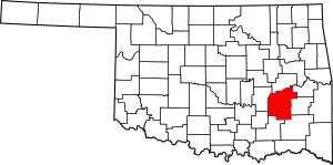
Location within the U.S. state of Oklahoma
|
|
 Oklahoma's location within the U.S. |
|
| Country | |
| State | |
| Founded | 1907 |
| Named for | Pittsburgh, Pennsylvania |
| Seat | McAlester |
| Largest city | McAlester |
| Area | |
| • Total | 1,378 sq mi (3,570 km2) |
| • Land | 1,305 sq mi (3,380 km2) |
| • Water | 72 sq mi (190 km2) 5.3%% |
| Population
(2020)
|
|
| • Total | 43,773 |
| • Density | 31.766/sq mi (12.265/km2) |
| Congressional district | 2nd |
Pittsburg County is a county in the state of Oklahoma. In 2020, about 43,773 people lived there. The main city and government center is McAlester.
The county was created in 1907. It was formed from land that belonged to the Choctaw Nation. Leaders named it Pittsburg County because it produced a lot of coal. They thought it was like Pittsburgh, Pennsylvania, a famous coal city.
Pittsburg County is also part of the McAlester, OK micropolitan area. This means it's a smaller city area that is important for jobs and services.
Contents
Discovering Pittsburg County's Past
The land that is now Pittsburg County was once part of the Choctaw Nation. The Choctaw tribe moved here in the early 1830s. They came from their homes in the southeastern United States. This move was part of a forced relocation.
How the Choctaw Nation Divided Land
The Choctaw Nation had its own way of dividing land. They used natural features like mountains and rivers as borders. This was different from how Oklahoma later set up its counties. Today's Pittsburg County was in two Choctaw areas. These were the Moshulatubbee District and Pushmataha District. It also included parts of five smaller Choctaw counties.
Important Trails and Early Settlements
Many important paths crossed this area. The Texas Road and a route of the California Trail passed through here. In 1840, a village called Perryville was started by James Perry. It became a key stop where these two trails met.
During the American Civil War, Perryville was a supply center for the Confederate army. But the Union Army captured and burned the town. Later, a railroad called the Missouri, Kansas and Texas Railway (MK&T) was built. It did not go through Perryville. So, the people living there moved to McAlester. The Butterfield Overland Mail route also went through this area.
The Role of J. J. McAlester
James J. McAlester moved to the Choctaw Nation in 1872. He opened a trading post. He also married a Chickasaw woman. This allowed him to become a citizen of the Choctaw and Chickasaw Nations.
When the MK&T railroad was built, McAlester found coal deposits near Perryville. He and his partners leased these coal mines. They leased them to a company owned by the Missouri Pacific Railroad. This company was later bought by the MK&T in 1888.
The County's Founding and Coal Mining History
Pittsburg County was officially formed on July 16, 1907. It was one of the first counties created from Choctaw land. Leaders named it after Pittsburgh, Pennsylvania. They thought its coal production was just as good.
Coal mining grew a lot until the early 1900s. But after 1920, coal production started to slow down. It never fully recovered. By 1966, coal mining was no longer a major industry in the county.
Understanding Pittsburg County's Landscape
Pittsburg County covers about 1,378 square miles. About 1,305 square miles are land. The remaining 72 square miles (5.3%) are water. The land is mostly hilly or mountainous. The Ouachita Mountains reach into the southeastern part of the county.
The Canadian River flows through most of the county. It forms the northern border with Eufaula Lake. Several creeks in the southern part of the county flow into the Kiamichi River. This river then flows into the Red River.
Neighboring Counties
Pittsburg County shares borders with these other counties:
- McIntosh County (north)
- Haskell County (northeast)
- Latimer County (east)
- Pushmataha County (southeast)
- Atoka County (south)
- Coal County (southwest)
- Hughes County (west)
Population Trends in Pittsburg County
The number of people living in Pittsburg County has changed over time.
| Historical population | |||
|---|---|---|---|
| Census | Pop. | %± | |
| 1910 | 47,650 | — | |
| 1920 | 52,570 | 10.3% | |
| 1930 | 50,778 | −3.4% | |
| 1940 | 48,985 | −3.5% | |
| 1950 | 41,031 | −16.2% | |
| 1960 | 34,360 | −16.3% | |
| 1970 | 37,521 | 9.2% | |
| 1980 | 40,524 | 8.0% | |
| 1990 | 40,581 | 0.1% | |
| 2000 | 43,953 | 8.3% | |
| 2010 | 45,837 | 4.3% | |
| 2020 | 43,773 | −4.5% | |
| U.S. Decennial Census 1790-1960 1900-1990 1990-2000 2010 |
|||
In 2010, there were 45,837 people living in the county. The population density was about 13 people per square kilometer. About 23.5% of the population was under 18 years old. The median age was 39 years. By 2020, the population had decreased slightly to 43,773 people.
Pittsburg County's Economic Journey
Pittsburg County was first known for its coal mining. But farming has always been important too. After Oklahoma became a state, farms covered 20% of the county's land. Corn and cotton were the main crops.
Over time, other crops became more important. By 1960, sorghum was the top crop. In 2000, wheat had become the most important crop.
Manufacturing and Tourism Growth
Manufacturing became a big part of the economy during World War II. The U.S. Navy built an ammunition depot in McAlester. It employed 8,000 people in 1945. The U.S. Army took over this facility in 1977.
Between 1956 and 1964, the Corps of Engineers built Eufaula Lake. This brought more tourism to the area. It also led to new land development. The lake became a major source of hydroelectric power.
Communities in Pittsburg County
Pittsburg County has several cities, towns, and other communities.
Cities
- Haileyville
- Hartshorne
- Krebs
- McAlester (the county seat)
Towns
Census-Designated Places
These are areas that are like towns but are not officially incorporated.
Other Unincorporated Places
Education in Pittsburg County
Many school districts serve the students of Pittsburg County.
K-12 Schools
These schools teach students from kindergarten through 12th grade:
- Canadian Public Schools
- Clayton Public Schools
- Crowder Public Schools
- Haileyville Public Schools
- Hartshorne Public Schools
- Indianola Public Schools
- Kiowa Public Schools
- McAlester Public Schools
- Pittsburg Public Schools
- Quinton Public Schools
- Savanna Public Schools
- Stuart Public Schools
Elementary Schools Only
These schools focus on younger students:
- Frink-Chambers Public School
- Haywood Public School
- Krebs Public School
- Tannehill Public School
There is also Jones Academy. This school is connected to the Bureau of Indian Education (BIE). It offers education for grades 1–6 and boarding for grades 7–12.
Historic Places in Pittsburg County
Many places in Pittsburg County are listed on the National Register of Historic Places. These sites are important because of their history.
- Aldridge Hotel, McAlester
- Blackburn's Station Site, Pittsburg
- Busby Office Building, McAlester
- Busby Theatre, McAlester
- Canadian Jail and Livery Stable, Canadian
- Choate Cabin, Indianola
- Cole Chapel School, Hartshorne
- Federal Building and US Courthouse, McAlester
- First Presbyterian Church, McAlester
- Hokey's Drugstore, Krebs
- Jeff Lee Park Bath House and Pool, McAlester
- Mass Grave of the Mexican Miners, McAlester
- McAlester Armory, McAlester
- McAlester DX, McAlester
- McAlester House, McAlester
- McAlester Scottish Rite Temple, McAlester
- Mine Rescue Station Building, McAlester
- New State School, McAlester
- OKLA Theater, McAlester
- Perryville, McAlester
- Pittsburg County Courthouse, McAlester
- Pittsburg School and Gymnasium, Pittsburg
- Southern Ice and Cold Storage Company, Pittsburg
- St. Joseph's Catholic Church, Krebs
- Tipton Ridge School, Blocker
See also
 In Spanish: Condado de Pittsburg para niños
 | Percy Lavon Julian |
 | Katherine Johnson |
 | George Washington Carver |
 | Annie Easley |

