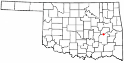
Indianola, Pittsburg County, Oklahoma facts for kids
Quick facts for kids
Indianola, Oklahoma
|
|
|---|---|

Location of Indianola, Oklahoma
|
|
| Country | United States |
| State | Oklahoma |
| County | Pittsburg |
| Area | |
| • Total | 0.32 sq mi (0.83 km2) |
| • Land | 0.32 sq mi (0.83 km2) |
| • Water | 0.00 sq mi (0.00 km2) |
| Elevation | 663 ft (202 m) |
| Population
(2020)
|
|
| • Total | 148 |
| • Density | 463.95/sq mi (178.92/km2) |
| Time zone | UTC-6 (Central (CST)) |
| • Summer (DST) | UTC-5 (CDT) |
| ZIP code |
74442
|
| Area code(s) | 539/918 |
| FIPS code | 40-36950 |
| GNIS feature ID | 2412793 |
Indianola is a small town in Pittsburg County, Oklahoma, in the United States. In 2020, about 148 people lived there. This was a decrease from 162 people counted in 2010.
Contents
History of Indianola
Indianola likely started around 1875. That's when H. M. McElhany moved to the area. He opened a small one-room store. This store also helped local people get their mail. Mail was brought by horseback from the nearby town of Canadian, Oklahoma.
McElhany ran the store for about three years. Then, he sold it to Albert S. Cornelison and James H. Bynum. A real post office was officially set up in Indianola, Indian Territory, on January 16, 1891. James H. Bynum became the first postmaster.
When Indianola was founded, it was part of Tobucksy County in the Choctaw Nation.
How Indianola Got Its Name
There are two main stories about how Indianola got its name. One story says the name was on a stove in the general store. The other story says the town was named to honor Indianola, Mississippi.
Town Growth and Relocation
The first school in Indianola opened in February 1895. In 1898, Lyman H. Perkins, a Choctaw farmer, gave 1 acre (0.4 hectares) of his land. This land was used to build a Methodist church.
In 1902, the Fort Smith and Western Railway built train tracks north of the town. Indianola quickly moved closer to these new tracks. The people built a new school building in the new location. Lyman Perkins and his wife also gave 4 acres (1.6 hectares) to the new town. The town kept the name Indianola. The old location was then called "Old Town." By 1910, Indianola had 781 residents. This was the most people the town has ever had.
Geography of Indianola
Indianola is located on the south bank of the South Canadian River. It is about 18 miles (29 km) north of McAlester.
The town covers a total area of 0.3 square miles (0.8 square kilometers). All of this area is land. Indianola is 663 feet (211 meters) above sea level.
Population Changes
| Historical population | |||
|---|---|---|---|
| Census | Pop. | %± | |
| 1910 | 481 | — | |
| 1920 | 415 | −13.7% | |
| 1930 | 378 | −8.9% | |
| 1940 | 311 | −17.7% | |
| 1950 | 314 | 1.0% | |
| 1960 | 234 | −25.5% | |
| 1970 | 205 | −12.4% | |
| 1980 | 254 | 23.9% | |
| 1990 | 171 | −32.7% | |
| 2000 | 191 | 11.7% | |
| 2010 | 162 | −15.2% | |
| 2020 | 148 | −8.6% | |
| U.S. Decennial Census | |||
In 2000, Indianola had 191 people living in 72 households. About 32% of these households had children under 18. Most households were married couples living together.
The population was spread out by age. About 29% of residents were under 18. About 15% were 65 years or older. The average age in the town was 36 years.
Economy
The main way people in Indianola have made a living is through farming. Cotton was the most important crop grown. Other important crops in the area included corn, grains, soybeans, peanuts, and onions.
See also

- In Spanish: Indianola (Oklahoma) para niños
 | Jackie Robinson |
 | Jack Johnson |
 | Althea Gibson |
 | Arthur Ashe |
 | Muhammad Ali |

