
McAlester, Oklahoma facts for kids
Quick facts for kids
McAlester, Oklahoma
|
|
|---|---|

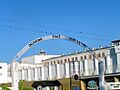
Downtown McAlester in January 2008
|
|
| Nickname(s):
Mactown
|
|

Location of McAlester, Oklahoma
|
|

McAlester, Oklahoma
Location in the United States
|
|
| Country | United States |
| State | Oklahoma |
| County | Pittsburg |
| Area | |
| • Total | 17.93 sq mi (46.43 km2) |
| • Land | 17.80 sq mi (46.10 km2) |
| • Water | 0.13 sq mi (0.33 km2) |
| Elevation | 742 ft (226 m) |
| Population
(2020)
|
|
| • Total | 18,171 |
| • Density | 1,020.84/sq mi (394.16/km2) |
| Time zone | UTC-6 (Central (CST)) |
| • Summer (DST) | UTC-5 (CDT) |
| ZIP Codes |
74501–74502
|
| Area code(s) | 539/918 |
| FIPS code | 40-44800 |
| GNIS feature ID | 2411056 |
McAlester is a city in Oklahoma, and it's the main town of Pittsburg County. In 2020, about 18,171 people lived there. The city is named after James Jackson McAlester, who was an early settler and businessman. He later became the lieutenant governor of Oklahoma. J. J. McAlester married Rebecca Burney, who was from the Chickasaw family, which made him a citizen of the Chickasaw Nation.
McAlester is home to the Oklahoma State Penitentiary, a large prison. This prison is sometimes called "Big Mac" because of its location in the city. Many people who work at the McAlester Army Ammunition Plant also live in McAlester. This plant makes most of the bombs used by the United States military. In 1998, the Defense Ammunition Center (DAC) also moved to the McAlester Army Ammunition Plant.
Contents
History of McAlester, Oklahoma
.jpg)
McAlester started as a natural meeting point where two important roads crossed: the east-west California Road and the north-south Texas Road. When the town was first founded, it was part of the Choctaw Nation.
In 1838, a settlement was started at this crossroads by Alyssia Young. The town was named Perryville after James Perry, a member of a Choctaw family who opened a trading post there. Perryville was once the capital of the Choctaw Nation.
McAlester During the Civil War
During the American Civil War, the Choctaw Nation supported the Confederate States of America (CSA). A supply depot for Confederate forces was set up in Perryville. On August 26, 1863, Union soldiers attacked and destroyed this depot. This event is known as the Battle of Perryville, Indian Territory. The Union general, James G. Blunt, ordered the town to be burned because it was a major supply center for the Confederates. Perryville was rebuilt, but it never became as big or important as it was before the war.
How McAlester Was Founded
After the Civil War ended in 1865, Captain J. J. McAlester learned about coal deposits in the Indian Territory. He had seen maps of these coal deposits during the war. McAlester convinced a trading company to open a general store in an area with rich coal deposits. He built his first trading post in late 1869.
McAlester saw a big opportunity in the coal. He started getting rights to mine the coal from the Choctaw people. He knew that a railroad was planning to build tracks through the Indian Territory.
The Railroad Arrives in McAlester
The Missouri-Kansas-Texas Railroad, also called the Katy Railroad, was building a line south towards Texas. J. J. McAlester took a sample of his coal to the railroad officials. He wanted them to build the line near his store. The railroad decided to build their tracks through the area. In 1872, the Katy Railroad reached McAlester, and they named the railway stop after him.
When the railroad arrived, businesses from nearby Perryville moved to be closer to the new McAlester Rail Depot. This was the end of Perryville and the start of McAlester. On August 22, 1872, J. J. McAlester married Rebecca Burney, a member of the Chickasaw Nation. This allowed him to become a citizen of the Chickasaw Nation and own land, including the rights to the coal. He opened another store and continued to sell coal to the railroads.
Growth of North and South McAlester
In 1885, a man named Fritz Sittle suggested building an east-west rail line through the coal mining area of Krebs that would connect with the north-south line at McAlester. This new railroad, the Choctaw Coal and Railway, was built.
Because of this new railroad, a new community grew south of McAlester's original store. This new area was called South McAlester. Miners from Pennsylvania and Italy came to McAlester in the 1870s to work in the coal mines. South McAlester grew much faster than the original town, which became known as North McAlester.
In 1907, the United States Congress decided to combine North and South McAlester into one city called McAlester. This happened just before Oklahoma became a state. At that time, the city had 8,144 people.
Recent Events in McAlester
McAlester was on the route of the Jefferson Highway, a long road built in 1915 that stretched from Canada to Louisiana.
In December 2000, a big ice storm hit the area. Many residents lost electricity and water for over two weeks. Another severe ice storm happened in January 2007, causing similar problems.
Geography and Climate
McAlester is located in Pittsburg County. It sits where U.S. Route 69 and U.S. Route 270 cross. The city covers about 46 square kilometers (17.9 square miles) of land.
McAlester has a humid subtropical climate. This means it has hot, humid summers and mild winters. The average temperature in January is about 4.4°C (40°F), and in July, it's about 27.6°C (81.7°F).
Population and People
| Historical population | |||
|---|---|---|---|
| Census | Pop. | %± | |
| 1900 | 646 | — | |
| 1910 | 11,774 | 1,722.6% | |
| 1920 | 10,632 | −9.7% | |
| 1930 | 11,804 | 11.0% | |
| 1940 | 12,401 | 5.1% | |
| 1950 | 17,878 | 44.2% | |
| 1960 | 17,419 | −2.6% | |
| 1970 | 18,802 | 7.9% | |
| 1980 | 17,255 | −8.2% | |
| 1990 | 16,370 | −5.1% | |
| 2000 | 17,783 | 8.6% | |
| 2010 | 18,383 | 3.4% | |
| 2020 | 18,171 | −1.2% | |
| Sources: | |||
In 2000, there were 17,783 people living in McAlester. About 74.7% of the people were White, 8.7% were African American, and 10.5% were Native American. About 3% of the population was Hispanic or Latino.
The city's population was spread out in terms of age. About 22.2% were under 18 years old, and 18% were 65 years or older. The average age in McAlester was 38 years.
Economy and Jobs
.jpg)
In the early 1900s, farming and coal mining were very important to McAlester's economy. Cotton was a major crop, and the city had cotton gins and presses. However, a pest called the boll weevil destroyed the cotton crops. Also, railroads started using oil instead of coal, which led to the decline of the coal industry.
Today, the Oklahoma State Penitentiary is a big source of jobs and income for McAalester. During World War II, the U.S. Government built a Naval Ammunition Plant near the city. In 1977, this became the U.S. Army Ammunition Plant. It is still the main place where ammunition for the United States military is made and stored.
Community Organizations
McAlester Main Street is a group that works to protect and improve the historic areas of Old Town and Downtown McAlester. It's a partnership with the city, the Oklahoma Department of Commerce, and the National Trust for Historic Preservation.
Education in McAlester

The McAlester Public Schools system runs the public schools in the city. The McAlester Public Library was built in 1970. There are plans to build a new library, with funding from the Friends of the McAlester Public Library.
McAlester is also home to the Kiamichi Technology Center, which helps over 300 students each year learn new skills. There is also a branch of Eastern Oklahoma State College called the Wanda Bass Higher Education Center. This center works with Southeastern Oklahoma State University and East Central University.
Transportation
McAlester is a hub for transportation. It is served by several major roads and highways, including:
- Indian Nation Turnpike
- Interstate 40
- U.S. Highway 69
- U.S. Highway 270
The city also has bus service through Greyhound Lines. For air travel, the McAlester Regional Airport is located just southwest of town. It has a paved runway for planes.
Places to Visit
- Garrard Ardeneum
- McAlester's Largest Lump of Coal
- Oklahoma State Penitentiary (a major landmark)
Famous People from McAlester
Many notable people have connections to McAlester, including:
- Carl Albert, who was the speaker of the U.S. House of Representatives.
- Mary Blair, a talented artist and Disney animator.
- Reba McEntire, a famous singer and actress.
- George Nigh, who was the Governor of Oklahoma.
- Steven W. Taylor, a former mayor of McAlester and an Oklahoma Supreme Court Justice.
Historic Sites in McAlester
Several places in McAlester are listed on the National Register of Historic Places, meaning they are important historical sites. These include:
- Aldridge Hotel
- Federal Building and US Courthouse
- First Presbyterian Church
- International Temple, Supreme Assembly, Order of the Rainbow for Girls
- McAlester Scottish Rite Temple
- Pittsburg County Courthouse
- Perryville (the original settlement site)
Images for kids
-
The Oklahoma State Penitentiary, established in 1911, is a source of employment and local revenue in McAlester
-
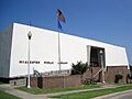
McAlester Public Library
-
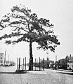
When this street in McAlester was paved in 1916, the city saved this pine tree and built a fence around it
See also
 In Spanish: McAlester (Oklahoma) para niños
