Porum, Oklahoma facts for kids
Quick facts for kids
Porum, Oklahoma
|
|
|---|---|
|
Town
|
|

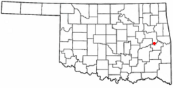
Location of Porum, Oklahoma
|
|
| Country | United States |
| State | Oklahoma |
| County | Muskogee |
| Area | |
| • Total | 0.92 sq mi (2.37 km2) |
| • Land | 0.89 sq mi (2.31 km2) |
| • Water | 0.02 sq mi (0.06 km2) |
| Elevation | 584 ft (178 m) |
| Population
(2020)
|
|
| • Total | 602 |
| • Density | 674.89/sq mi (260.45/km2) |
| Time zone | UTC-6 (Central (CST)) |
| • Summer (DST) | UTC-5 (CDT) |
| ZIP code |
74455
|
| Area code(s) | 539/918 |
| FIPS code | 40-60250 |
| GNIS feature ID | 2412500 |
Porum is a town located in Muskogee County, Oklahoma, United States. It was named after John Porum Davis. He was a rancher, a veteran of the Civil War, and a councilman for the Cherokee Nation.
The community was first known as Porum Gap. In 1905, it joined with another nearby village called Starvilla. This union created the town of Porum as we know it today. In 2010, the town had a population of 727 people.
History of Porum
The area around Porum has a long and interesting history. It includes stories of the Starr family, who were part of the Cherokee "Treaty faction." This group faced challenges during the early days of the Cherokee Nation.
A post office was first set up in Porum Gap on March 25, 1890. The Midland Valley Railroad also came to the Porum area in 1903. The official town of Porum was formed in 1905. This happened after Porum Gap and Starvilla merged together.
Geography and Location
Porum is located about 30 miles (48 kilometers) south of Muskogee. Muskogee is the county seat, which means it is the main city of Muskogee County.
According to the United States Census Bureau, the town covers a total area of 0.8 square miles (2.1 square kilometers). Most of this area, 0.8 square miles (2.1 square kilometers), is land. A small part, about 0.04 square miles (0.1 square kilometers), is water.
Population and People
| Historical population | |||
|---|---|---|---|
| Census | Pop. | %± | |
| 1910 | 548 | — | |
| 1920 | 533 | −2.7% | |
| 1930 | 471 | −11.6% | |
| 1940 | 502 | 6.6% | |
| 1950 | 616 | 22.7% | |
| 1960 | 573 | −7.0% | |
| 1970 | 658 | 14.8% | |
| 1980 | 668 | 1.5% | |
| 1990 | 851 | 27.4% | |
| 2000 | 725 | −14.8% | |
| 2010 | 727 | 0.3% | |
| 2020 | 602 | −17.2% | |
| U.S. Decennial Census | |||
The census helps us count the number of people living in a place. As of the year 2000, there were 725 people living in Porum. These people lived in 301 households, and 202 of these were families.
The population density was about 964 people per square mile (372 people per square kilometer). This tells us how many people live in a certain amount of space. There were also 341 housing units in the town.
About 31.6% of households had children under 18 living with them. About 43.9% were married couples living together. Also, 16.9% of households had someone living alone who was 65 years old or older.
The average household had about 2.41 people. The average family had about 2.97 people.
See also
In Spanish: Porum (Oklahoma) para niños
 | Claudette Colvin |
 | Myrlie Evers-Williams |
 | Alberta Odell Jones |

