Talbot County, Georgia facts for kids
Quick facts for kids
Talbot County
|
|
|---|---|

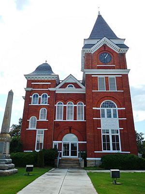
Talbot County Courthouse and Confederate Monument in Talbotton
|
|

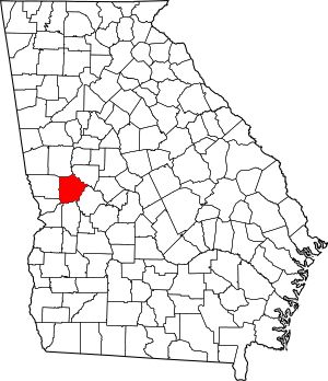
Location within the U.S. state of Georgia
|
|
 Georgia's location within the U.S. |
|
| Country | |
| State | |
| Founded | December 14, 1827 |
| Named for | Matthew Talbot |
| Seat | Talbotton |
| Largest city | Talbotton |
| Area | |
| • Total | 395 sq mi (1,020 km2) |
| • Land | 391 sq mi (1,010 km2) |
| • Water | 3.4 sq mi (9 km2) 0.9%% |
| Population
(2020)
|
|
| • Total | 5,733 |
| • Density | 15/sq mi (6/km2) |
| Time zone | UTC−5 (Eastern) |
| • Summer (DST) | UTC−4 (EDT) |
| Congressional district | 2nd |
Talbot County is a place in the middle-west part of Georgia, a state in the United States. It's called a county, which is like a smaller area within a state.
In 2020, about 5,733 people lived here. The main town, where the county government is, is called Talbotton. It's also the biggest town in the county.
Contents
History of Talbot County
Talbot County was created a long time ago, on December 14, 1827. It was made from a piece of land that used to be part of Muscogee County.
The county was named after Matthew Talbot. He was a governor of Georgia before the county was formed. Later, in 1852, another county called Taylor County was made from a part of Talbot County.
Geography of Talbot County
Talbot County covers about 395 square miles. Most of this area, about 391 square miles, is land. The rest, about 3.4 square miles, is water.
Land and Rivers
The county sits on something called the fall line. This is a natural boundary where the land changes. Because of this, the northern parts of Talbot County have more hills. The southern parts are flatter.
The Fall Line Freeway is a major road that goes through the southern part of the county. It follows Georgia State Route 96 from Geneva to Junction City. In the very north of the county, you can find parts of the Pine Mountain Range. Some of these mountains are over 1,000 feet tall!
Most of Talbot County is in the Upper Flint River area. This river system is part of a bigger one called the Apalachicola-Chattahoochee-Flint River Basin. A smaller part of the county in the southwest is near the Middle Chattahoochee River.
Main Roads in Talbot County
Lots of important roads run through Talbot County. These roads help people travel and connect different towns.
Neighboring Counties
Talbot County shares its borders with several other counties.
- Upson County - to the northeast
- Taylor County - to the southeast
- Marion County - to the south
- Chattahoochee County - to the southwest
- Muscogee County - to the west-southwest
- Harris County - to the west
- Meriwether County - to the north
Railroads
Railroads are important for moving goods and materials. Talbot County has lines from two major railroad companies:
Communities in Talbot County
Talbot County has several towns and cities where people live.
Cities
- Talbotton (This is the main county seat)
- Woodland
- Manchester (Only a part of this city is in Talbot County)
Towns
Other Communities
Some smaller places in the county are called unincorporated communities. They don't have their own city government.
- Box Springs
- Centerville
- Po Biddy Crossroads
- Tax Crossroads
Population of Talbot County
| Historical population | |||
|---|---|---|---|
| Census | Pop. | %± | |
| 1830 | 5,940 | — | |
| 1840 | 15,627 | 163.1% | |
| 1850 | 16,534 | 5.8% | |
| 1860 | 13,616 | −17.6% | |
| 1870 | 11,913 | −12.5% | |
| 1880 | 14,115 | 18.5% | |
| 1890 | 13,258 | −6.1% | |
| 1900 | 12,197 | −8.0% | |
| 1910 | 11,696 | −4.1% | |
| 1920 | 11,158 | −4.6% | |
| 1930 | 8,458 | −24.2% | |
| 1940 | 8,141 | −3.7% | |
| 1950 | 7,687 | −5.6% | |
| 1960 | 7,127 | −7.3% | |
| 1970 | 6,625 | −7.0% | |
| 1980 | 6,536 | −1.3% | |
| 1990 | 6,524 | −0.2% | |
| 2000 | 6,498 | −0.4% | |
| 2010 | 6,865 | 5.6% | |
| 2020 | 5,733 | −16.5% | |
| 2023 (est.) | 5,718 | −16.7% | |
| U.S. Decennial Census 1790-1880 1890-1910 1920-1930 1930-1940 1940-1950 1960-1980 1980-2000 2010 2020 |
|||
The population of Talbot County has changed over many years. In 2020, there were 5,733 people living there. These people lived in about 2,809 households. About 1,849 of these were families.
The county is home to people from many different backgrounds. In 2020, about 42% of the people were White. About 53% were Black or African American. There were also smaller groups of Native American, Asian, and people of mixed races. About 2% of the population was Hispanic or Latino.
Education in Talbot County
The Talbot County School District is in charge of schools in the county. It provides education for students from pre-school all the way to twelfth grade.
The district has one main building. There are 48 full-time teachers who help teach about 792 students. The main office for the school district is in Talbotton.
See also
 In Spanish: Condado de Talbot (Georgia) para niños
 | Leon Lynch |
 | Milton P. Webster |
 | Ferdinand Smith |

