
Woodland, Georgia facts for kids
Quick facts for kids
Woodland, Georgia
|
|
|---|---|

Woodland in 2012.
|
|

Location in Talbot County and the state of Georgia
|
|
| Country | United States |
| State | Georgia |
| County | Talbot |
| Area | |
| • Total | 0.79 sq mi (2.05 km2) |
| • Land | 0.79 sq mi (2.03 km2) |
| • Water | 0.01 sq mi (0.01 km2) |
| Elevation | 791 ft (241 m) |
| Population
(2020)
|
|
| • Total | 305 |
| • Density | 388.54/sq mi (149.98/km2) |
| Time zone | UTC-5 (Eastern (EST)) |
| • Summer (DST) | UTC-4 (EDT) |
| ZIP code |
31836
|
| Area code(s) | 706 |
| FIPS code | 13-83952 |
| GNIS feature ID | 0356649 |
Woodland is a small city located in Talbot County, Georgia, in the United States. In 2020, about 305 people lived there. It's a quiet place with a rich history.
Contents
History of Woodland
The community of Woodland got its name from C.S. Woods. He was the first owner of the land where the town was built. In 1908, the Georgia General Assembly officially made Woodland a town. This meant it could have its own local government.
Where is Woodland Located?
Woodland is found at a specific spot on the map: 32.787594 degrees North and 84.561018 degrees West. These numbers help pinpoint its exact location in the world. The city covers a total area of about 0.8 square miles (2.05 square kilometers). All of this area is land, meaning there are no large lakes or rivers within the city limits.
Who Lives in Woodland?
Every ten years, the United States counts its population in something called a census. This helps us understand how many people live in a place and what groups they belong to.
Population Changes Over Time
The number of people living in Woodland has changed over many years. Here's how the population has grown and shrunk:
| Historical population | |||
|---|---|---|---|
| Census | Pop. | %± | |
| 1910 | 189 | — | |
| 1920 | 356 | 88.4% | |
| 1930 | 463 | 30.1% | |
| 1940 | 489 | 5.6% | |
| 1950 | 621 | 27.0% | |
| 1960 | 720 | 15.9% | |
| 1970 | 689 | −4.3% | |
| 1980 | 664 | −3.6% | |
| 1990 | 552 | −16.9% | |
| 2000 | 432 | −21.7% | |
| 2010 | 408 | −5.6% | |
| 2020 | 305 | −25.2% | |
| U.S. Decennial Census 1850-1870 1870-1880 1890-1910 1920-1930 1940 1950 1960 1970 1980 1990 2000 2010 2020 |
|||
Different Groups in Woodland
The census also looks at the different racial and ethnic groups that make up a city. This table shows the mix of people in Woodland over the years. Remember, "Hispanic/Latino" is an ethnic group, and people from this group can be of any race.
| Race / Ethnicity (NH = Non-Hispanic) | Pop 2000 | Pop 2010 | Pop 2020 | % 2000 | % 2010 | % 2020 |
|---|---|---|---|---|---|---|
| White alone (NH) | 90 | 95 | 55 | 20.83% | 23.28% | 18.03% |
| Black or African American alone (NH) | 336 | 307 | 236 | 77.78% | 75.25% | 77.38% |
| Native American or Alaska Native alone (NH) | 1 | 3 | 1 | 0.23% | 0.74% | 0.33% |
| Asian alone (NH) | 0 | 0 | 1 | 0.00% | 0.00% | 0.33% |
| Pacific Islander alone (NH) | 0 | 0 | 0 | 0.00% | 0.00% | 0.00% |
| Some Other Race alone (NH) | 1 | 0 | 1 | 0.23% | 0.00% | 0.33% |
| Mixed Race or Multi-Racial (NH) | 3 | 3 | 5 | 0.69% | 0.74% | 1.64% |
| Hispanic or Latino (any race) | 1 | 0 | 6 | 0.23% | 0.00% | 1.97% |
| Total | 432 | 408 | 305 | 100.00% | 100.00% | 100.00% |
In 2000, there were 432 people living in Woodland, making up 181 households and 131 families. By 2020, the population had decreased to 305 people.
Images for kids
-
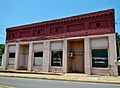
Woodland City Hall and Police Department
-
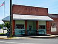
Woodland Post Office (ZIP code: 31836)
-

Woodland Volunteer Fire Department
-
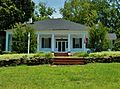
Located three miles east of Woodland, The Elms was built in 1838 and placed on the National Register of Historic Places. Robert H. Dixon, a Georgia State Senator and State Representative (1843) from Talbot County, owned this land from 1827 to 1857.

.JPG)

.JPG)
See also
 In Spanish: Woodland (Georgia) para niños
