
Upson County, Georgia facts for kids
Quick facts for kids
Upson County
|
|
|---|---|
.JPG)
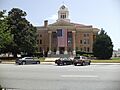
Upson County Courthouse in Thomaston
|
|

Location within the U.S. state of Georgia
|
|
 Georgia's location within the U.S. |
|
| Country | |
| State | |
| Founded | December 15, 1824 |
| Named for | Stephen Upson |
| Seat | Thomaston |
| Largest city | Thomaston |
| Area | |
| • Total | 328 sq mi (850 km2) |
| • Land | 323 sq mi (840 km2) |
| • Water | 4.1 sq mi (11 km2) 1.3%% |
| Population
(2020)
|
|
| • Total | 27,700 |
| • Density | 86/sq mi (33/km2) |
| Time zone | UTC−5 (Eastern) |
| • Summer (DST) | UTC−4 (EDT) |
| Congressional district | 3rd |
Upson County is a county located in the central part of Georgia, a state in the United States. In 2020, about 27,700 people lived here. The main town and center of the county is Thomaston. Upson County was officially created on December 15, 1824.
The county is part of the larger area around Thomaston. This area is also connected to bigger cities like Atlanta, Athens-Clarke County, and Sandy Springs.
Contents
A Look Back at Upson County's History
Upson County was formed in 1824. It was named after Stephen Upson, who was an important person in the state government at the time.
Emancipation Day: A Special Celebration
On May 29, 1865, a very important event happened in Upson County. This was after the American Civil War ended. People who had been enslaved were told in Thomaston that they were now free.
The very next year, people started celebrating this day. These celebrations have continued every year since then. It is one of the biggest and oldest celebrations of freedom in Georgia and in the entire United States.
Exploring Upson County's Geography
Upson County covers about 328 square miles. Most of this area, about 323 square miles, is land. The rest, about 4.1 square miles, is water. Upson County is known for having the lowest average summer humidity in Georgia. This means the air feels less sticky during the summer months.
Most of Upson County is located near the upper part of the Flint River. This river is part of a larger system called the ACF River Basin. A small part of the county, near Yatesville, is in the upper part of the Ocmulgee River basin.
Main Roads in Upson County
Several important roads run through Upson County, helping people travel around.
 U.S. Route 19
 U.S. Route 80
 State Route 3
 State Route 22
 State Route 36
 State Route 74
 State Route 74 Alternate
Neighboring Counties
Upson County shares its borders with several other counties:
- Lamar County - to the north
- Pike County - to the north
- Monroe County - to the northeast
- Crawford County - to the southeast
- Taylor County - to the south
- Talbot County - to the southwest
- Meriwether County - to the northwest
Towns and Communities
Upson County has one main city and several smaller towns and communities.
City
Town
Other Places to Live
These are areas where people live that are officially recognized:
- Hannahs Mill
- Lincoln Park
- Salem
- Sunset Village
These are other communities that are not officially cities or towns:
- Atwater
- Crest
- Dog Crossing
- The Rock
Who Lives in Upson County?
| Historical population | |||
|---|---|---|---|
| Census | Pop. | %± | |
| 1830 | 7,013 | — | |
| 1840 | 9,408 | 34.2% | |
| 1850 | 9,424 | 0.2% | |
| 1860 | 9,910 | 5.2% | |
| 1870 | 9,430 | −4.8% | |
| 1880 | 12,400 | 31.5% | |
| 1890 | 12,188 | −1.7% | |
| 1900 | 13,670 | 12.2% | |
| 1910 | 12,757 | −6.7% | |
| 1920 | 14,786 | 15.9% | |
| 1930 | 19,509 | 31.9% | |
| 1940 | 25,064 | 28.5% | |
| 1950 | 25,078 | 0.1% | |
| 1960 | 23,800 | −5.1% | |
| 1970 | 23,505 | −1.2% | |
| 1980 | 25,998 | 10.6% | |
| 1990 | 26,300 | 1.2% | |
| 2000 | 27,597 | 4.9% | |
| 2010 | 27,153 | −1.6% | |
| 2020 | 27,700 | 2.0% | |
| 2023 (est.) | 28,263 | 4.1% | |
| U.S. Decennial Census 1790-1880 1890-1910 1920-1930 1930-1940 1940-1950 1960-1980 1980-2000 2010 |
|||
| Group | Number of People | Percentage |
|---|---|---|
| White (not Hispanic or Latino) | 18,009 | 65.01% |
| Black or African American (not Hispanic or Latino) | 7,851 | 28.34% |
| Native American | 63 | 0.23% |
| Asian | 151 | 0.55% |
| Pacific Islander | 1 | 0.0% |
| Other/Mixed (two or more races) | 992 | 3.58% |
| Hispanic or Latino (of any race) | 633 | 2.29% |
In 2020, the census counted 27,700 people living in Upson County. There were 10,154 households, which are groups of people living together. Out of these, 6,100 were families.
Famous People from Upson County
Many interesting people have come from Upson County, including:
- James L. Bentley
- C.C. Crews
- Martha Hudson
- John Brown Gordon
- Coy Bowles
Images for kids
-
Upson County Courthouse in Thomaston
See also
 In Spanish: Condado de Upson para niños
