
Ocmulgee River facts for kids
Quick facts for kids Ocmulgee River |
|
|---|---|

Ocmulgee River in Telfair County
|
|

Map of the Ocmulgee River watershed highlighted; river is dark blue
|
|
| Country | United States |
| State | Georgia |
| Physical characteristics | |
| Main source | Confluence of South, Yellow, and Alcovy rivers Lloyd Shoals Dam 33°19′15″N 83°50′39″W / 33.32083°N 83.84417°W |
| River mouth | Altamaha River Hazlehurst |
| Length | 255 mi (410 km) |
| Basin features | |
| Tributaries |
|
The Ocmulgee River is a long river in Georgia, USA. It flows for about 255 miles (410 km) and is a main branch of the Altamaha River. This river and its smaller streams drain a huge area of central Georgia. It covers about 6,180 square miles across 33 counties. The river's name might come from the Hitchiti language. It could mean "where the water boils up."

Contents
About the River
The Ocmulgee River starts in north central Georgia, southeast of Atlanta. It forms where three rivers meet: the Yellow, South, and Alcovy rivers. These rivers now join together in the Jackson Lake reservoir. The river's starting point is about 530 feet above sea level.
The Ocmulgee River flows southeast from the dam, passing by the city of Macon. It then meets the Oconee River to form the Altamaha River near Lumber City. You can enjoy the Ocmulgee River Water Trail, which stretches for about 200 miles. It goes from Macon's Amerson River Park all the way to where the Ocmulgee joins the Altamaha.
How People Use the River
Several power plants in the Ocmulgee basin use the river's water. One important plant is Plant Scherer in Juliette. This plant uses coal to make electricity. It is one of the largest coal-fueled power plants in the United States.
Fish and Wildlife
The Ocmulgee River basin is home to many different kinds of fish. There are 105 species of fish found here! The most common types are carp and minnows, with 27 species. Sunfish are also very common, with 22 species. You can also find ten types of catfish and eight types of suckers.
Rare and Endangered Fish
The Ocmulgee basin has some special fish species. One is the Altamaha shiner, which is an endangered species. This means it is at risk of disappearing forever. Two other rare species are the goldstripe darter and the redeye chub.
Fishing in the Ocmulgee
The Ocmulgee River is a great place for fishing. Many people enjoy catching fish like redbreast sunfish, bluegill, redear sunfish, and largemouth bass. You can also find black crappie, channel catfish, and flathead catfish.
A famous fishing record happened here! In 1932, a farmer named George Washington Perry caught the world's largest largemouth bass. He caught it in Montgomery Lake, which is a small lake connected to the Ocmulgee River. This huge fish weighed 22 pounds, 4 ounces. In 2010, this world record was tied by another angler in Japan.
Fish That Don't Belong
There are about fifteen types of fish in the river basin that are not native to the area. These are called invasive species. They can sometimes harm the native fish populations. Some examples include goldfish, common carp, and flathead catfish.
River History
People have lived near the Ocmulgee River for a very long time. Archeologists have found tools and spearpoints from Paleoindian hunters. These early people lived here about 10,000 to 15,000 years ago.
Early Native American Life
During the Archaic period (around 8000-1000 BCE), hunter-gatherers lived in the Ocmulgee basin. They used pottery and stone tools. Later, during the Woodland period (around 1000 BCE-900 CE), villages appeared. We know this from earthen mounds and pottery pieces found there.
The Mississippian culture arrived in the Ocmulgee basin around 900 CE. They built large farms and gardens around special ceremonial mounds. These areas are now part of the Ocmulgee National Monument. It is a protected area managed by the National Park Service.
European Arrival and Changes
The first Europeans explored the Ocmulgee basin in 1540. This was during the expedition of the Spanish explorer Hernando de Soto. His group visited a Native American village called Ichisi, which is now near Macon. The people of Ichisi offered them corncakes, wild onions, and roasted deer meat. However, over the next hundred years, many Native Americans in the area suffered greatly from diseases brought by Europeans.
The invention of the cotton gin by Eli Whitney changed the area. This machine made it easier to process cotton. This led to more cotton farms and a greater demand for land. In 1806, the U.S. government gained control of the land between the Oconee and Ocmulgee rivers from the Creek Indians. A fort was built there, called Fort Benjamin Hawkins. The Creek people held their last meeting at Ocmulgee Fields in 1819 before giving up this territory in 1821.
In the 1800s, the river became an important way to transport goods. Barges and steamboats used the river. This helped the cotton industry grow in the region. In 1842, a railroad connected the river to Savannah. The river even froze completely in 1886! In 1994, heavy rains caused big floods on the river, leading to damage around Macon.
Ocmulgee Creeks
Many smaller creeks flow into the Ocmulgee River. Here are some of the major ones:
- Tucsawhatchee Creek
- Echeconnee Creek
- This creek's name means "deer trap" in the Muscogee language. The Creek people would lure deer into steep areas of the creek to trap them.
- Alligator Creek
- Big Indian Creek
- Coley Creek
- Big Horse Creek
- Flat Creek
- Folsom Creek
- Horse Creek
- Jordan Creek
- Limestone Creek
- Little Ocmulgee River (Gum Swamp Creek)
- Little Shellstone Creek
- Little Sturgeon Creek
- Mossy Creek
- Otter Creek
- Richland Creek
- Sandy Run Creek
- Savage Creek
- Shellstone Creek
- South Shellstone Creek
- Sturgeon Creek
- Sugar Creek
- Ten Mile Creek
- Walnut Creek
Images for kids
-
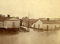
Ocmulgee River flood in Spring 1876
.jpeg)
See also
 In Spanish: Río Ocmulgee para niños
