
Ocmulgee Mounds National Historical Park facts for kids
Quick facts for kids Ocmulgee Mounds National Historical Park |
|
|---|---|
|
IUCN Category V (Protected Landscape/Seascape)
|
|

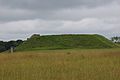
The Great Temple Mound (right) and the Lesser Mound (left)
|
|

Ocmulgee Mounds National Historical Park
Location in Georgia (U.S. state)

Ocmulgee Mounds National Historical Park
Location in the United States
|
|
| Location | Macon, Georgia, USA |
| Area | 3,336 acres (13.50 km2) |
| Established | December 23, 1936 |
| Visitors | 122,722 (in 2011) |
| Governing body | National Park Service |
| Website | Ocmulgee Mounds National Historical Park |
| NRHP reference No. | 66000099 |
| Added to NRHP | October 15, 1966 |
Ocmulgee Mounds National Historical Park in Macon, Georgia, USA, protects amazing clues about people who lived here over 10,000 years ago. The most famous parts are the huge earthworks, or mounds, built by the Mississippian culture before the year 1000 CE. These include the Great Temple Mound, other special ceremonial mounds, and even a burial mound.
These ancient people were very skilled engineers. They knew a lot about soil and worked together to build these massive structures. The park shows that people have lived here for 12,000 years! This 3,336-acre park sits on the east side of the Ocmulgee River. The city of Macon grew up around this area after a fort was built nearby in 1806.
For thousands of years, different groups of Native Americans settled on the Macon Plateau. This area is special because it's where the rolling hills meet the flat coastal plain. The park also includes the Lamar Mounds and Village Site, which is a few miles downriver. This important site became a national monument in 1934 and was renamed a national historical park in 2019.
Contents
History of the Mounds
Ancient Builders of the Macon Plateau
Ocmulgee (say it: oh-k-MUL-gee) means 'Bubbling Water' in the Mikasuki language. It's a special place that remembers the ancient people of North America. From Ice Age hunters to the Muscogee Creek tribe, people have lived here for 12,000 years.
The most important time was between 950 and 1150 CE. During this period, a smart and organized society built the huge earthworks you see today. Archaeologists call these people the Macon Plateau culture. They were part of the larger Mississippian culture.
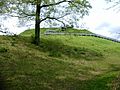
These people had leaders and skilled farmers. They worked together to build large, flat-topped mounds. Thousands of workers carried earth by hand to build the 55-foot-high Great Temple Mound. It sits on a high cliff overlooking the Ocmulgee River. Scientists have found that this mound had a spiral staircase, which is very rare for Mississippian sites! There is also at least one burial mound here.
The people built rectangular wooden buildings on top of the mounds for important ceremonies. The mounds at Ocmulgee are unique because they are spread out more than at other Mississippian sites. This might have allowed for more public spaces and homes around them.
They also built round earth lodges for meetings and ceremonies. One earth lodge was built around 1050 CE. Archaeologists later rebuilt it at the park center. Inside, there's a raised platform shaped like an eagle, with special seats for leaders. The eagle was an important symbol shared by many Mississippian cultures.
,_circa_1876_-_DPLA_-_fd9cf4e1f3cae2a47fea5873b13fd50f.jpg)
The Lamar Period People
Around 1350 CE, a new culture grew among people living in the swamps downstream. This was called the Lamar Period. These people built two mounds that are still there today, including a unique spiral mound.
The Lamar people had a village near their mounds. They protected it with a tall fence made of logs called a palisade. Their houses were rectangular with thatched roofs and clay-covered walls. This ancient village site is now part of the Lamar Mounds and Village Site.
Lamar pottery was special, with complex designs stamped into it. Many archaeologists think the Lamar culture was a mix of earlier Woodland people and the Mississippian culture.
First European Contact
In 1540, a Spanish explorer named Hernando de Soto traveled through this area. Historians believe he visited what is now the Lamar site. The Spanish left a path of destruction as they searched for gold. They also brought pigs, which escaped and caused problems for the local environment.
Even worse, the Spanish brought new diseases from Europe. Native Americans had no protection against these illnesses, and many people died. This caused big changes and likely led to the decline of the Mississippian cultures. The large chiefdoms (societies led by chiefs) fell apart. Smaller groups and tribes formed, and they didn't build the huge mounds anymore.
Muscogee Creek in Later Times
By the late 1700s, the Muscogee Creek people were a large group in what is now Georgia and Alabama. They spoke a language called Muskogean.
The Muscogee considered the ancient mounds at Ocmulgee to be sacred. They believed it was "the place where we first sat down" after their ancestors traveled from the West.
In 1690, Scottish fur traders built a trading post near the Ocmulgee River. Some Muscogee people settled nearby to trade. They exchanged animal furs for European goods like cloth, beads, tools, and rifles. These traders often married Muscogee women, which helped create strong alliances.
The Muscogee and their European allies sometimes raided Spanish missions in Florida. This warfare, along with diseases, caused the Native American population in Florida to drop sharply.
In 1715, the Ochese Creek (a group within the Muscogee) joined a war against the colonists. They burned the trading post at Ocmulgee. Because of these conflicts, the Ochese Creek moved west to the Chattahoochee River.
Later, the colony of Georgia was founded. Many Ochese Creek moved to Spanish Florida. There, they joined other groups and runaway enslaved people to form a new tribe called the Seminole.
Relations with the United States
Travelers in the 1700s were amazed by the Ocmulgee mounds. The naturalist William Bartram visited in 1774 and 1776. He wrote about the "wonderful remains" of ancient power. He was the first to write down the Muscogee stories about how the mounds began.
At first, the Muscogee had good relations with the US government. But after the cotton gin was invented in 1794, people in Georgia wanted more land for cotton farms. They started moving onto Muscogee territory.
In 1805, the Muscogee gave up their lands east of the Ocmulgee River to Georgia. But they refused to give up the sacred mounds. They kept a special area called the Ocmulgee Old Fields Reserve, which included the mounds.
In 1806, Thomas Jefferson ordered Fort Benjamin Hawkins to be built overlooking the mounds. This fort was important for the military and for trading with the Creek Nation.
Tensions grew between different Muscogee groups and with the American settlers. The US and Georgia used the fort during the Creek War of 1813–1814. General Andrew Jackson defeated a group of Muscogee called the Red Sticks.
In 1821, a Muscogee chief named William McIntosh signed a treaty that gave the Ocmulgee Old Fields to the United States. Soon after, the city of Macon was founded.
The Muscogee National Council had made it a serious crime to sell communal lands. But in 1825, Chief McIntosh signed another treaty, giving away more Muscogee lands. Other Muscogee leaders were very angry. They attacked McIntosh's home and killed him for selling their shared lands.
The Muscogee tried to protest the treaty to President John Quincy Adams. A new treaty was made, but Georgia still pushed the Muscogee off their lands.
In 1828, Andrew Jackson became president. He supported removing Native Americans from their lands. In the 1830s, the US Army forced the Muscogee, Cherokee, Choctaw, Chickasaw, and most Seminole tribes to move west of the Mississippi River. This sad journey is known as the Trail of Tears.
After being removed, the Muscogee rebuilt their nation in what is now Oklahoma. In 1867, they named their new capital Okmulgee to honor their sacred mounds in Georgia.
Ocmulgee Mounds National Historical Park Today
Park History and Growth
Archaeologists began studying the mounds in the 1930s. Workers from the Works Progress Administration (WPA) dug up parts of eight mounds between 1933 and 1942. They found many important artifacts that showed a wide trading network and a complex culture. The site became a national monument in 1936 and was added to the National Register of Historic Places in 1966.
In 2019, the site was renamed Ocmulgee Mounds National Historical Park. Its size also grew by about 2,100 acres. More land was added to the park in 2022, stopping other types of development nearby.
What You Can See and Do
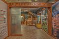
The park's visitor center has an archaeology museum. It shows artifacts and tells the story of the different Native American cultures that lived here for thousands of years. You can also learn about the historic Muscogee Creek tribe. The visitor center has a short film and a gift shop.
The park covers 702 acres and has 5.5 miles of walking trails. Near the visitor center, you can see a reconstructed ceremonial earthlodge. It's built just like the 1,000-year-old structure found by archaeologists. You can walk inside and imagine what meetings were like long ago.
You can reach the Great Temple Mound by walking about half a mile or driving on the park road. Other ancient features include a burial mound, other platform mounds, and earthwork trenches. The site of an old English colonial trading post is also part of the park.
The main part of Ocmulgee Mounds National Historical Park is easy to get to from U.S. Route 80 or Interstate 16. It's open every day except Christmas Day and New Year's Day. The Lamar Mounds and Village Site is a bit further away and has limited visiting hours.
Future Plans for the Park
In 2022, the National Park Service studied the Ocmulgee River area. They looked at whether the park could become an even larger national park and preserve. This study included areas like the Bond Swamp National Wildlife Refuge. The Muscogee Nation might help manage this larger area.
In November 2023, the study found that making it a huge national park would be too expensive right now. However, it did say the area was very important. It suggested a smaller plan, working with the Muscogee Nation and others. As of 2024 and 2025, bills have been introduced in Congress to establish Ocmulgee Mounds National Park and Preserve.
Images for kids
-
-
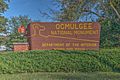
Park entrance sign
-
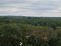
Looking up at the Great Temple Mound from the bluff
-
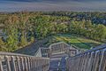
View from the top of the Great Temple Mound
-
The Great Temple Mound
-
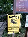
Gator Sign at Ocmulgee Mounds National Historic Park
-
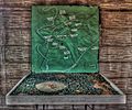
Map on display at Fort Hawkins


Archaeology Museum
-
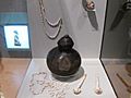
Pipes, necklaces, and a pottery vessel found at Ocmulgee
-
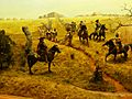
A drawing of a raiding party passing the Ocmulgee trading post
-
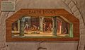
Earth Lodge Display
-
Detail of the museum


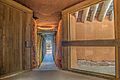
Ocmulgee Earth Lodge
-
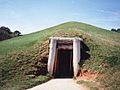
Entrance to the earth lodge
-
Interior of the earth lodge
-
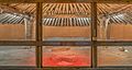
Interior of the earth lodge
-
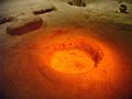
Earthlodge fireplace. Nearby were 47 molded seats for leaders on the eagle platform.


See also
