Moundville Archaeological Site facts for kids
|
Moundville Archaeological Site
|
|

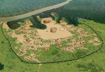
Artist's conception of the Moundville Archaeological Site
|
|
| Location | 634 Mound State Parkway Moundville, Alabama, US |
|---|---|
| Nearest city | Tuscaloosa |
| NRHP reference No. | 66000149 |
Quick facts for kids Significant dates |
|
| Added to NRHP | October 15, 1966 |
| Designated NHL | July 19, 1964 |
The Moundville Archaeological Site, also known as Moundville Archaeological Park, is a very important place where ancient Mississippian culture people lived. It's located on the Black Warrior River in Hale County, near the city of Tuscaloosa, Alabama.
Scientists have studied this site a lot. They found that it was a major center for a group of Native American people called the Mississippian culture. This community was important for their leaders and special events between the 11th and 16th centuries.
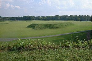
Today, the park is managed by the University of Alabama Museums. It covers about 185 acres (75 hectares). You can see 29 large platform mounds there, all arranged around a big, open area called a plaza.
Moundville was named a National Historic Landmark in 1964. It was added to the National Register of Historic Places in 1966. It is the second-largest site from the classic Middle Mississippian era in the United States, after Cahokia in Illinois. The Mississippian culture spread across the central Mississippi River Valley and other parts of the southeastern U.S. The park also has a museum and a special lab for studying artifacts.
Contents
Exploring Moundville's Past
People have known about Moundville for a long time. In the mid-1800s, researchers like E. G. Squier and Edwin Hamilton Davis mentioned it in their studies. Later, Nathaniel Thomas Lupton made a good map of the area.
The first big archaeological digs happened in the early 1900s. Clarence Bloomfield Moore, a lawyer, did a lot of digging in 1906. His detailed notes are still helpful to today's archaeologists. Sadly, over the next 20 years, some people dug into the mounds without permission and took many valuable items, damaging parts of the site.
Saving the Site
In the 1920s, concerned citizens, including Walter B. Jones (geologist), worked hard to protect Moundville. With help from the Alabama Museum of Natural History, they bought the land. By 1933, it was officially called Mound State Park.
The park was developed for visitors in 1938. During the Great Depression, workers from the Civilian Conservation Corps helped. They made sure the mounds wouldn't wash away and built roads and buildings for visitors. The park opened to the public in 1939, then called Mound State Monument.
In 1980, some valuable pottery was stolen from the museum. While three ceremonial bowls were anonymously returned in 2018, many items are still missing. In 1991, the park's name officially changed to Moundville Archaeological Park.
More recently, in 2021, a committee recognized that the site is connected to several Native American tribes. These tribes have asked for the return of human remains and special objects found at the site.
What Moundville Looked Like
Native American people of the Mississippian culture lived here from about 1000 AD to 1450 AD. Around 1150 AD, the leaders of Moundville started to become very powerful in the region.
At its busiest, Moundville was a large town covering about 300 acres (120 hectares). A strong wooden fence, called a palisade, protected three sides of the town. The Black Warrior River protected the fourth side.
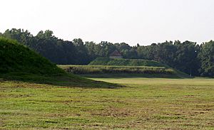
The largest platform mounds were built on the north side of the central plaza. The mounds got smaller as you went around the plaza to the south. Experts believe that the most important families lived near the biggest mounds. The smaller mounds likely had buildings for homes, burials, or other uses. Today, 29 mounds are still visible at the site.
Mound A is in the very center of the great plaza. Mound B is just north of it. Mound B is a tall, 58-foot (18-meter) pyramid-shaped mound with two ramps. Archaeologists have also found evidence of places where dirt was dug out, other public buildings, and many small houses made of poles and thatch.
This layout of the community shows how their society was organized. Different family groups, called clans, had their own areas. The size and arrangement of the mounds showed their importance. By 1300, Moundville was used more for religious and political events than as a place where many people lived. This was the start of its decline, and by 1500, most of the area was empty.
Who Lived at Moundville?
The area around Moundville was home to many people. However, they didn't build many mounds before 1200 AD. After that, they built the plaza and many mounds. At its peak, about 1,000 to 3,000 people lived inside the town walls. Another 10,000 people lived in the surrounding river valley.
People at Moundville were very good at farming, especially growing maize (corn). Growing extra corn meant they had time to make other things and trade. This also allowed more people to live close together and for some to become skilled craftspeople.
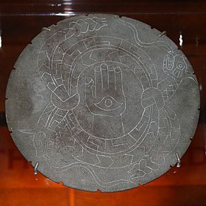
Archaeologists have found many fancy items at Moundville. These include things made from copper, mica, galena, and seashells, which were brought from far away. Moundville is famous for its beautiful pottery, stone carvings, and copper art. These items show the amazing artistic skills of the people who once lived there.
Moundville's Location
The Moundville Archaeological Site sits on a high bank overlooking the Black Warrior River. This site and other related settlements are in a part of the Black Warrior River Valley. This area is just south of modern-day Tuscaloosa, Alabama, and stretches about 25 miles (40 kilometers) downriver.
The valley here is wide, with rolling hills and small streams. This region is a mix of different environments, with plants and animals from temperate oak-hickory forests, maritime magnolia forests, and pine forests.
See Also
- Bottle Creek Mounds
- Jere Shine site
- Ocmulgee Mounds National Historical Park
- Taskigi Mound
- List of National Historic Landmarks in Alabama
 | Anna J. Cooper |
 | Mary McLeod Bethune |
 | Lillie Mae Bradford |


