
Black Warrior River facts for kids
Quick facts for kids Black Warrior River |
|
|---|---|

The Black Warrior River passes by a park in downtown Tuscaloosa, Alabama. The Hugh R. Thomas Bridge is seen in the background
|
|

Map of the Black Warrior River watershed
|
|
| Country | United States |
| State | Alabama |
| Physical characteristics | |
| Main source | Confluence of the Mulberry and Locust forks Jefferson and Walker counties, Alabama, United States 255 ft (78 m) 33°33′25″N 87°11′9″W / 33.55694°N 87.18583°W |
| River mouth | Tombigbee River Demopolis, Alabama, United States 125 ft (38 m) 32°31′55″N 87°51′11″W / 32.53194°N 87.85306°W |
| Length | 178 mi (286 km) |
| Basin features | |
| Basin size | 6,275 sq mi (16,250 km2) |
The Black Warrior River is a cool waterway in west-central Alabama, in the southeastern United States. It starts in the southern part of the Appalachian Highlands. The river flows for 178 miles (286 km) until it reaches the Tombigbee River. The Black Warrior is the main river that flows into the Tombigbee.
The river got its name from a Native American chief named Tuskaloosa. His name meant 'Black Warrior' in the Muskogean languages. The Black Warrior River has many locks and dams along its path. These create a series of lakes, which help boats travel and also make electricity. The river also provides drinking water and water for factories.
The river flows through the Black Warrior Basin. This area is known for its coal and natural gas. Cities like Tuscaloosa and Northport grew up along the river. They were important places for boats to stop. Even Birmingham, a big city nearby, used the river to transport goods. The entire area that the river drains, called its watershed, is about 6,275 square miles (16,250 km2).
Where the River Flows
The Black Warrior River begins about 22 miles (40 km) west of Birmingham. It forms where two smaller rivers, the Mulberry Fork and the Locust Fork, join together. This meeting point is part of Bankhead Lake. This lake is a long, narrow reservoir created by the Bankhead Lock and Dam.
After Bankhead Lake, the river flows into Holt Lake, then into Oliver Lake. These three lakes cover the first 60 miles (80 km) of the river. They stretch into Tuscaloosa County and the city of Tuscaloosa. After Oliver Dam, the Black Warrior River flows south. It has many twists and turns before joining the Tombigbee River at Demopolis. The last 30 miles (48 km) of the river are part of Lake Demopolis.
The Black Warrior River also gets water from the North River. This river joins about one mile (1.6 km) northeast of Tuscaloosa. The North River was dammed in 1968 to create Lake Tuscaloosa. This lake is the main source of drinking water for Tuscaloosa and nearby areas.
River Crossings
There are not many places to cross the Black Warrior River by car. Outside of Tuscaloosa County, there are only three bridges. Within Tuscaloosa County, there are seven crossings. None of these are upstream of the Paul Bryant Bridge in Tuscaloosa.
River's Past
Over time, the Black Warrior River has had many different names. Some of these include Apotaka Hacha River and Tuskaloosa River.
In the past, people often called the river the "Warrior River" above Tuscaloosa. Below Tuscaloosa, they called it the "Black Warrior River." Even today, some people still use these names. However, the official name for the entire river, from Bankhead Lake south, is the Black Warrior River.
In the 1880s, the U.S. government started building a system of locks and dams. This was done to help the coal industry in central Alabama. The first 16 locks and dams were built using large blocks of sandstone from the riverbanks. These were carefully shaped by hand. Some of these old dams were used until the 1960s. You can still see a part of one old stone lock (Lock 3, later Lock 12) at University Park in Tuscaloosa.
A concrete dam, Lock 17 (also called the John H. Bankhead Lock and Dam), was finished in 1915. It is the only original dam still in use today. It has been updated over the years. Lock 17 and Holt Lock and Dam also have hydroelectric power plants. These plants are owned by the Alabama Power Company and provide electricity to the area.
This system of locks and dams made the Black Warrior River easy to travel by boat. It became part of a long waterway that connects the Gulf of Mexico to Birmingham. This helped Birmingham become known as the "Pittsburgh of the South." It shipped iron and steel products all over the world, even through the Panama Canal. High-quality coal is still sent by barge to Mobile. From there, it is shipped worldwide, making Mobile a very busy coal port. Coal mining is still a big job in west-central Alabama.
Today, one big problem for the Black Warrior River is sedimentation. This means too much dirt and sand build up in the river. It happens because of new building projects, logging, mining, and road construction.
-
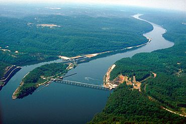
Bankhead Lock and Dam, which creates Bankhead Lake in Tuscaloosa County
-
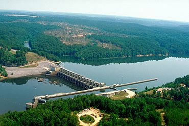
Holt Lock and Dam, which creates Holt Lake in Tuscaloosa County
-
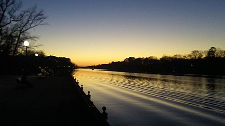
The Black Warrior River at Riverwalk Park in Tuscaloosa, Alabama
-
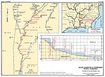
A map from the U.S. Army Corps of Engineers showing the Black Warrior and Tombigbee Rivers


See also
 In Spanish: Río Guerrero Negro para niños
