Demopolis, Alabama facts for kids
Quick facts for kids
Demopolis, Alabama
|
||
|---|---|---|
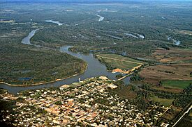
Aerial view of Demopolis. The meeting point of the Tombigbee and Black Warrior rivers is in the center.
|
||
|
||
| Nickname(s):
City of the People, Jewel of the Black Belt, The River City, The Canebrake, Demop
|
||
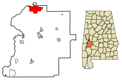
Location in Marengo County, Alabama
|
||
| Country | United States | |
| State | Alabama | |
| County | Marengo | |
| Incorporated | December 11, 1821 | |
| Area | ||
| • Total | 18.066 sq mi (46.791 km2) | |
| • Land | 17.744 sq mi (45.956 km2) | |
| • Water | 0.322 sq mi (0.835 km2) | |
| Elevation | 121 ft (37 m) | |
| Population
(2020)
|
||
| • Total | 7,162 | |
| • Estimate
(2022)
|
6,882 | |
| • Density | 388/sq mi (149.8/km2) | |
| Time zone | UTC−6 (Central (CST)) | |
| • Summer (DST) | UTC−5 (CDT) | |
| ZIP Code |
36732
|
|
| Area code(s) | 334 | |
| FIPS code | 01-20296 | |
| GNIS feature ID | 0117222 | |
Demopolis is the biggest city in Marengo County, located in west-central Alabama. In 2020, about 7,162 people lived there.
The city is built where the Black Warrior River and Tombigbee River meet. It sits on a tall cliff called White Bluff. This cliff is made of a type of rock called Demopolis Chalk. Demopolis is also in a special area of Alabama known as the Canebrake and the Black Belt.
Demopolis was founded in the early 1800s. This was after Napoleon's empire in France ended. A group of French people, including some who supported Napoleon, came to the United States. They had also fled from a revolution in Saint-Domingue (now Haiti).
The name "Demopolis" comes from ancient Greek words. It means "the People's City" or "City of the People." This name was chosen to honor ideas of democracy. It was first settled in 1817, making it one of Alabama's oldest towns away from the coast. Demopolis officially became a city on December 11, 1821.
Contents
History of Demopolis
Early Settlement
French people who had left France first gathered in Philadelphia. They asked the U.S. Congress to sell them land to start a new home. In 1817, Congress agreed. They could buy land in the Alabama Territory to grow grapevines and olive trees. They thought Alabama's climate would be good for these plants. By July 1817, a small group settled at White Bluff. This is where Demopolis is today. They called their new home the Vine and Olive Colony.
Some of the French settlers were important people. One was Count Lefebvre Desnouettes, a general who had served Napoleon. However, many of these French people were not used to living like pioneers. They sold their shares in the colony and stayed in Philadelphia. By 1818, only 69 settlers remained.
The settlers faced many challenges. In 1818, they learned that their land was not where Congress had approved. The Vine and Olive Colony had to move. Their actual land grants were a little further east. After leaving Demopolis, they started two other towns: Aigleville and Arcola.
American Growth
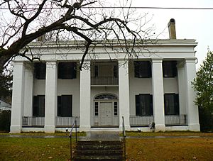
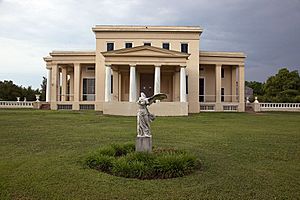
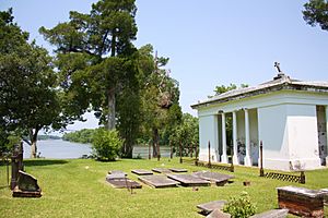
When Americans found out the French land grants were elsewhere, they quickly bought the old French settlement. They wanted to make it a big river port. A company called the White Bluff Association was formed in 1819. Their goal was to buy the land and plan a town. George Strother Gaines bought the land at White Bluff.
The town was planned with a grid plan, like the city of Philadelphia. Streets running north and south were named after trees. East and west streets were named after heroes and important people. Most streets were about 66 feet wide. The land along the Tombigbee River was kept public for everyone to use.
By the late 1820s, some issues with the town plan appeared. The lots were not big enough for the large homes wealthy people wanted. Still, some grand houses were built. One of the first was the Allen Glover house. Glover also built Bluff Hall (1832) for his daughter.
The town also needed a clear business area. Stores started opening around the town square. Warehouses appeared near the river landings. By the 1830s, Demopolis became an important trading center on the river. Many craftsmen and merchants moved there. Plantation owners also built homes in or near the town.
However, Demopolis was not just for wealthy plantation owners. The river trade brought many different kinds of people. This led to many taverns and gave the town a lively reputation.
In the 1840s, the town council worked to open more streets. They also built wooden sidewalks to help people avoid the mud. Laws were passed to control the enslaved African-American population. These laws limited their ability to buy or sell goods and restricted their movement.
Churches were slow to become established in Demopolis. Many early church groups met in a log building on the town square. The first churches were built around 1840. The Episcopalians built Trinity Episcopal Church in 1850. The Presbyterians and Methodists built their first churches in 1843.
The Catholic community, which included the original French settlers, met in a small church. The current Saint Leo the Great church was built in 1905. The Jewish community, B'nai Jeshurun, was formed in 1858. They built a beautiful Moorish Revival-style temple in 1893.
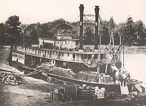
By the 1850s, many large steamboats regularly stopped in Demopolis. They traveled between Mobile and Columbus, Mississippi. Some steamboats were mainly used for the cotton trade. Major hotels like the Planter's Hotel also opened.
In 1853, a yellow fever outbreak hit the city. New cemeteries were established, including the Jewish Cemetery in 1878. The Glover Mausoleum was built in 1845. Finally, the city opened its main burial ground, Riverside Cemetery, in 1882.
A circular Gothic Revival-style amphitheater was built in 1859. It was part of the fairgrounds, which covered about 20 acres. These fairgrounds hosted many events until the Civil War began. By 1860, Demopolis had about 1,200 people. The town offered more entertainment, like music, plays, and circuses.
Civil War and Beyond
Marengo County, where Demopolis is located, had many slaveholders. Most white residents supported leaving the Union and forming the Confederate States of America. Many men from Demopolis joined Confederate companies during the Civil War. Sadly, more soldiers died from disease and hunger than from battles.
Demopolis was important during the war because of its rivers and railroad. It became a base for Confederate supplies and offices. There were hospitals and a large military camp. After major battles in 1863, thousands of Confederate soldiers came to Demopolis. The town, which had only about a thousand people before the war, struggled to feed and house them.
Many soldiers who died in the hospitals were buried in a Confederate cemetery. Today, this cemetery is underwater because the river was dammed later. In 1862, the Confederate government finished a railroad connecting Selma through Demopolis to Meridian, Mississippi.
In 1864, as the war continued, many refugees came to Demopolis. People from Mobile filled every empty house. In March 1865, Demopolis prepared to defend itself. They built forts and placed cannons. When Selma was about to fall, supplies and Confederate boats were sent to Demopolis.
After the war ended in May 1865, Union soldiers came to occupy Demopolis. They stayed at the old fairgrounds. The town's economy was devastated. The Episcopal Church in Demopolis mysteriously burned down during this time.
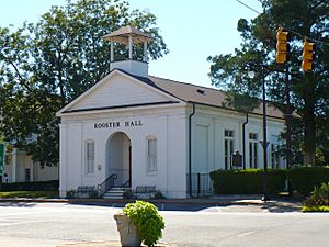
During the Reconstruction era, the county seat of Marengo County was moved from Linden to Demopolis in 1868. The county bought the Presbyterian church (now Rooster Hall) to use as a courthouse. They also built a brick building next door, which is Demopolis City Hall today. However, this move was very controversial. After a lot of debate and voting, the county seat was moved back to Linden in 1871. The buildings in Demopolis then became city property.
20th Century Changes
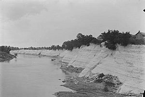
The economy of Demopolis struggled to recover into the 20th century. Growing and selling cotton was the main business until World War I. But then, tiny insects called boll weevils ruined cotton crops in the 1920s. The Great Depression in the 1930s also hurt the economy. This ended the system of relying on just one crop.
By the early 1900s, Demopolis had modern features. These included electric lights, running water, and paved sidewalks. It became a major center for banking and shopping. Important banks like Robertson Banking Company were established. Large stores like Mayer Brothers and Rosenbush Furniture Company opened. The Demopolis Times newspaper, started in 1904, is still published today.
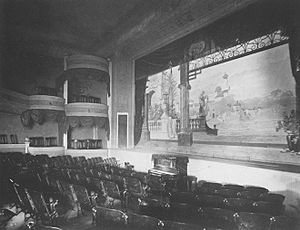
Theaters also became popular. Rooster Hall was used as the Demopolis Opera House from 1876 to 1902. It hosted plays and shows. The beautiful Braswell Opera House opened in 1902. It showed performances until the 1920s. The first movie theater, the Elks Theater, opened in 1915. It was later renamed the Si-Non.
After cotton farming declined, people started raising beef cattle. More recently, catfish farming became important. By the middle of the century, industries like cement, lumber, and paper became the main sources of jobs. These industries are still important to Demopolis today.
Geography
Demopolis is located at 32°31′03″N 87°50′11″W / 32.51750°N 87.83639°W.
The city covers about 18 square miles. Most of this area is land, with a small part being water.
Demopolis is on the northern edge of Marengo County. To the north, across the Black Warrior River, is Greene County. To the northwest, across the Tombigbee River, is Sumter County.
U.S. Route 43 goes through the city center. U.S. Route 80 runs along the southern edge of downtown. US 43 goes north to Eutaw and south to Linden. US 80 goes east to Uniontown and west to Cuba.
Climate
Demopolis has a humid subtropical climate. This means it has hot, humid summers. Winters are generally mild to cool.
| Climate data for Demopolis, Alabama, 1991–2020 normals, extremes 1951–present | |||||||||||||
|---|---|---|---|---|---|---|---|---|---|---|---|---|---|
| Month | Jan | Feb | Mar | Apr | May | Jun | Jul | Aug | Sep | Oct | Nov | Dec | Year |
| Record high °F (°C) | 81 (27) |
85 (29) |
89 (32) |
96 (36) |
99 (37) |
104 (40) |
105 (41) |
105 (41) |
103 (39) |
100 (38) |
88 (31) |
82 (28) |
105 (41) |
| Mean maximum °F (°C) | 74.2 (23.4) |
77.2 (25.1) |
83.1 (28.4) |
87.1 (30.6) |
92.4 (33.6) |
95.3 (35.2) |
97.2 (36.2) |
97.3 (36.3) |
94.3 (34.6) |
88.3 (31.3) |
80.7 (27.1) |
75.0 (23.9) |
98.5 (36.9) |
| Mean daily maximum °F (°C) | 56.7 (13.7) |
61.0 (16.1) |
69.2 (20.7) |
76.6 (24.8) |
84.3 (29.1) |
89.5 (31.9) |
92.0 (33.3) |
91.4 (33.0) |
87.0 (30.6) |
77.5 (25.3) |
66.7 (19.3) |
58.9 (14.9) |
75.9 (24.4) |
| Daily mean °F (°C) | 45.3 (7.4) |
48.9 (9.4) |
56.4 (13.6) |
63.7 (17.6) |
72.1 (22.3) |
78.6 (25.9) |
81.4 (27.4) |
80.9 (27.2) |
76.1 (24.5) |
65.2 (18.4) |
54.2 (12.3) |
47.6 (8.7) |
64.2 (17.9) |
| Mean daily minimum °F (°C) | 33.9 (1.1) |
36.8 (2.7) |
43.7 (6.5) |
50.8 (10.4) |
60.0 (15.6) |
67.6 (19.8) |
70.8 (21.6) |
70.4 (21.3) |
65.2 (18.4) |
53.0 (11.7) |
41.6 (5.3) |
36.2 (2.3) |
52.5 (11.4) |
| Mean minimum °F (°C) | 18.6 (−7.4) |
22.5 (−5.3) |
27.0 (−2.8) |
36.8 (2.7) |
45.9 (7.7) |
58.2 (14.6) |
64.7 (18.2) |
62.0 (16.7) |
53.1 (11.7) |
38.4 (3.6) |
27.2 (−2.7) |
21.8 (−5.7) |
16.1 (−8.8) |
| Record low °F (°C) | −2 (−19) |
6 (−14) |
15 (−9) |
25 (−4) |
40 (4) |
42 (6) |
54 (12) |
50 (10) |
36 (2) |
16 (−9) |
14 (−10) |
4 (−16) |
−2 (−19) |
| Average precipitation inches (mm) | 5.66 (144) |
5.45 (138) |
5.75 (146) |
4.85 (123) |
3.65 (93) |
4.65 (118) |
5.03 (128) |
4.85 (123) |
3.38 (86) |
3.25 (83) |
4.30 (109) |
5.39 (137) |
56.21 (1,428) |
| Average snowfall inches (cm) | 0.0 (0.0) |
0.0 (0.0) |
0.2 (0.51) |
0.0 (0.0) |
0.0 (0.0) |
0.0 (0.0) |
0.0 (0.0) |
0.0 (0.0) |
0.0 (0.0) |
0.0 (0.0) |
0.0 (0.0) |
0.0 (0.0) |
0.2 (0.51) |
| Average precipitation days (≥ 0.01 in) | 9.4 | 8.6 | 8.6 | 7.5 | 7.5 | 8.9 | 9.5 | 8.2 | 6.3 | 5.4 | 7.0 | 9.2 | 96.1 |
| Average snowy days (≥ 0.1 in) | 0.0 | 0.0 | 0.0 | 0.0 | 0.0 | 0.0 | 0.0 | 0.0 | 0.0 | 0.0 | 0.0 | 0.0 | 0.0 |
| Source 1: NOAA | |||||||||||||
| Source 2: National Weather Service | |||||||||||||
People of Demopolis
| Historical population | |||
|---|---|---|---|
| Census | Pop. | %± | |
| 1850 | 812 | — | |
| 1860 | 473 | −41.7% | |
| 1870 | 1,539 | 225.4% | |
| 1880 | 1,389 | −9.7% | |
| 1890 | 1,398 | 0.6% | |
| 1900 | 2,606 | 86.4% | |
| 1910 | 2,417 | −7.3% | |
| 1920 | 2,779 | 15.0% | |
| 1930 | 4,037 | 45.3% | |
| 1940 | 4,137 | 2.5% | |
| 1950 | 5,004 | 21.0% | |
| 1960 | 7,377 | 47.4% | |
| 1970 | 7,651 | 3.7% | |
| 1980 | 7,678 | 0.4% | |
| 1990 | 7,512 | −2.2% | |
| 2000 | 7,540 | 0.4% | |
| 2010 | 7,483 | −0.8% | |
| 2020 | 7,162 | −4.3% | |
| 2022 (est.) | 6,882 | −8.0% | |
| U.S. Decennial Census 2020 Census |
|||
2020 Census Information
| Race | Number | Percent |
|---|---|---|
| White | 2,900 | 40.49% |
| Black or African American | 3,869 | 54.02% |
| Native American | 1 | 0.01% |
| Asian | 46 | 0.64% |
| Pacific Islander | 1 | 0.01% |
| Other/Mixed | 140 | 1.95% |
| Hispanic or Latino | 205 | 2.86% |
In 2020, Demopolis had 7,162 people living in 2,973 households. There were 1,883 families. The city had about 403 people per square mile. There were 3,400 housing units in total.
2010 Census Information
In 2010, Demopolis had 7,483 people. There were 3,049 households and 1,998 families. The population density was about 613 people per square mile. There were 3,417 housing units. The city's population was 50.1% Black or African American and 47.3% White. About 2.4% of the people were Hispanic or Latino.
In 2010, 31.2% of households had children under 18. About 38.6% were married couples. The average household had 2.42 people. The average family had 3.04 people.
About 27.0% of the population was under 18. About 14.8% were 65 or older. The average age was 37.1 years.
The median income for a household was $35,583. For a family, it was $49,973. About 19.1% of families and 26.8% of the population lived below the poverty line.
Arts and Culture
Historic Places
Gaineswood is a historic house museum. It is listed on the National Register of Historic Places and is a National Historic Landmark. It was built between 1843 and 1861. It has a unique Greek Revival style with domed ceilings and fancy plasterwork. The Alabama Historical Commission takes care of Gaineswood.
Bluff Hall is another historic house museum. It is also on the National Register of Historic Places. It was built in 1832 and later changed to the Greek Revival style. The Marengo County Historical Society owns and runs Bluff Hall.
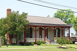
Laird Cottage is a restored house from 1870. It mixes Greek Revival and Italianate styles. It is now the main office for the Marengo County Historical Society. It also has history exhibits and art by Geneva Mercer. She was a local artist and sculptor.
Other historic places in Demopolis include White Bluff, the Demopolis Historic Business District, Demopolis Town Square, Lyon Hall, Ashe Cottage, the Curtis House, the Glover Mausoleum, and the Foscue-Whitfield House.
Education
Demopolis has its own public school system, called the Demopolis City School District. The city also has the Demopolis Higher Education Center. This center opened in 2004. It has a library, classrooms, computer labs, and meeting spaces.
Transportation
Two main U.S. Highways pass through Demopolis. U.S. Route 80 goes east-west. U.S. Route 43 goes north-south. Other state highways include State Route 8, SR 13, and nearby SR 69 and SR 28. There are plans for an Interstate 85 extension to pass near the city. West Alabama Transportation runs a bus system.
Demopolis is served by several railway companies. These include Norfolk Southern Railway, BNSF Railway, and the Alabama and Gulf Coast Railway.
The Port of Demopolis has docks on the river. These docks connect to waterways that reach the Great Lakes, the Ohio and Tennessee rivers, and the Gulf of Mexico. This is possible through the Tennessee-Tombigbee Waterway.
The Demopolis Municipal Airport is located northwest of the city. It has a 5,000-foot runway.
Greyhound Lines provides bus service between cities.
Notable People
- A. G. Gaston, a businessman and supporter of civil rights.
- Spencer Turnbull, a professional baseball pitcher.
- Theo Ratliff, a professional basketball player.
See also
 In Spanish: Demopolis (Alabama) para niños
 | Janet Taylor Pickett |
 | Synthia Saint James |
 | Howardena Pindell |
 | Faith Ringgold |


