Tombigbee River facts for kids
Quick facts for kids Tombigbee River |
|
|---|---|

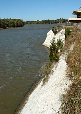
Tombigbee River at White Bluff (Ecor Blanc) in Demopolis
|
|

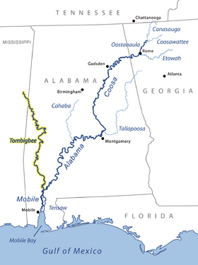
Tombigbee and Alabama river basins
|
|
| Country | United States |
| State | Alabama and Mississippi |
| Physical characteristics | |
| Main source | Confluence of Tennessee-Tombigbee Waterway and Black Warrior River |
| River mouth | Mobile River, at Mobile, Alabama |
| Length | 200 miles (320 km) |
The Tombigbee River is a long river in the United States. It flows for about 200 miles (325 km) through the states of Mississippi and Alabama. This river is a major branch of the Mobile River. It joins with the Alabama River to form the short Mobile River, which then flows into Mobile Bay and finally into the Gulf of Mexico.
The Tombigbee River is very important for boats and ships. It has special gates called locks that help boats travel along most of its length. Upstream, it connects to the Tennessee River through a big canal called the Tennessee–Tombigbee Waterway. This makes it a key route for trade and travel in the southern United States.
The name "Tombigbee" comes from the Choctaw language. It means "box maker" or "coffin maker." For hundreds of years, the river was the eastern border of the lands belonging to the Choctaw people. They lived there from the 1600s until the 1830s, when the United States government moved them to new lands.
Contents
River Journey

The Tombigbee River starts in northeastern Mississippi. It begins near the Pharr Mounds in Itawamba County. Long ago, people thought the river started where two smaller streams, Town Creek and the East Fork, met in Monroe County.
As the river flows, it passes through several lakes. These include Aberdeen Lake near Aberdeen and Columbus Lake near Columbus. It also flows through Aliceville Lake on the border between Mississippi and Alabama.
The river then turns south and winds its way through western Alabama. It goes past towns like Gainesville and Demopolis. In Demopolis, another important river, the Black Warrior River, joins the Tombigbee. South of Demopolis, the Tombigbee continues its journey south. It forms the border for some counties like Sumter and Choctaw counties.
Near Jackson, the Tombigbee River meets the Alabama River. This meeting point is about 30 miles (50 km) north of Mobile. When these two rivers join, they form the Mobile River.
The Tennessee-Tombigbee Waterway
In 1985, a huge project called the Tennessee–Tombigbee Waterway was finished. This waterway changed how the middle part of the Tombigbee River flows in northeastern Mississippi. Much of the river's path was made straighter and wider for boats. Above Aberdeen Lake, the new waterway runs right next to the original river path.
Rivers Joining the Tombigbee
Many other rivers and creeks flow into the Tombigbee River.
- The Buttahatchee River joins from the east, north of Columbus, Mississippi.
- South of Columbus, Luxapalila Creek flows into the Tombigbee.
- About 10 miles (15 km) north of Gainesville, the Sipsey River joins.
- At Gainesville, the Noxubee River flows in from the west.
The Choctaw National Wildlife Refuge is a special protected area along the river in southwestern Alabama. It's a home for many different animals and plants.
Native American History
The upper parts of the Tombigbee River were once the homeland of the powerful Chickasaw people. In the 1700s, a French official named Bienville used the Tombigbee to travel with his army. He led a campaign against the Chickasaw in 1736.
By the 1800s, the Chickasaw were known as one of the "Five Civilized Tribes" because they had adopted some ways of the European-American settlers. However, in 1830, the United States Congress passed a law called the Indian Removal Act. This law forced many Native American groups, including the Chickasaw, to move west of the Mississippi River. This meant they lost most of their land in the Southeast.
River Locks and Dams
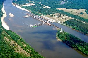
The Tombigbee River has five special structures called lock and dams. These help control the water level and allow boats to move up and down the river. They are listed from north to south, with their distance from the mouth of the Mobile River:
- John C. Stennis Lock & Dam is at river mile 334.7.
- Tom Bevill Lock & Dam is at river mile 306.8.
- Howell Heflin Lock & Dam is at river mile 266.1.
- Demopolis Lock & Dam is at river mile 213.2.
- Coffeeville Lock and Dam is at river mile 116.6.
Tributaries
These are some of the rivers and creeks that flow directly into the Tombigbee River:
- West River
- Bassetts Creek (Washington County)
- Bassett Creek (Clarke County)
- Jackson Creek
- Santa Bogue Creek
- Turkey Creek
- Okatuppa Creek
- Oak Slush Creek
- Big Tallawampa Creek
- Bashi Creek
- Wahalak Creek
- Sucarbowa Creek
- Horse Creek
- Tuckabum Creek
- Beaver Creek
- Kinterbish Creek
- Chickasaw Bogue
- Cotohaga Creek
- Sucarnoochee River
- Spring Creek
- Hall Creek
- Black Warrior River
- Brush Creek
- Trussells Creek
- Noxubee River
- Sipsey River
- Lubbub Creek
- Big Creek
- Luxapallila Creek
- Buttahatchee River
- Tibbee Creek
- Town Creek
- Bull Mountain Creek
Fun on the River
Many people enjoy using the Tombigbee Waterway for fun. Pleasure boats, especially those traveling America's Great Loop (a big boating route around the eastern U.S.), use the waterway every fall.
River Stories
The Tombigbee River is also known for some old stories about steamboat accidents. Two famous ones include the Eliza Battle and the James T. Staples.
See also
 In Spanish: Río Tombigbee para niños
 | Precious Adams |
 | Lauren Anderson |
 | Janet Collins |


