Choctaw County, Alabama facts for kids
Quick facts for kids
Choctaw County
|
||
|---|---|---|

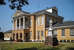
Choctaw County Courthouse and Confederate monument in Butler
|
||
|
||

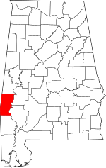
Location within the U.S. state of Alabama
|
||
 Alabama's location within the U.S. |
||
| Country | ||
| State | ||
| Founded | December 29, 1847 | |
| Named for | Choctaw tribe | |
| Seat | Butler | |
| Largest town | Butler | |
| Area | ||
| • Total | 921 sq mi (2,390 km2) | |
| • Land | 914 sq mi (2,370 km2) | |
| • Water | 7.4 sq mi (19 km2) 0.8% | |
| Population
(2020)
|
||
| • Total | 12,665 | |
| • Estimate
(2023)
|
12,252 |
|
| • Density | 13.751/sq mi (5.3094/km2) | |
| Time zone | UTC−6 (Central) | |
| • Summer (DST) | UTC−5 (CDT) | |
| Congressional district | 7th | |
|
||
Choctaw County is a county located in the southwestern part of Alabama. In 2020, about 12,665 people lived there. The main town and county seat is Butler. The county was started on December 29, 1847. It was named after the Choctaw tribe, a group of Native Americans.
Contents
History of Choctaw County
Choctaw County was once part of the Choctaw Nation. There were Choctaw villages near Pushmataha. This was before many Native Americans were moved from the southeastern United States. This forced move is known as the Trail of Tears.
Most of the first European American settlers in Choctaw County were farmers. They came from North and South Carolina. In 1912, a railroad was built through the county. It connected the area to the Port of Mobile in the south. This caused people to move from areas near the Tombigbee River to the center of the county.
The county's population grew a lot in the 1920s. This was because of many jobs in the sawmill industry. Companies like E. E. Jackson Lumber Company created work. But the sawmill business struggled during the Great Depression. In 1944, the first successful oil well in Alabama was drilled in Gilbertown. Oil and gas then became very important to the county. This industry became less profitable by the 1970s.
In 1956, a magazine article featured an African-American family from Mobile. The article included an interview with Allie Lee Causey. She was a schoolteacher from Choctaw County. Mrs. Causey spoke about her family's life. She said that "integration is the only way in which Negroes will receive justice." She believed that equal pay and fair jobs would lead to better homes and education. After the article, the Causey family faced many challenges. They had to leave their home in Alabama in October 1956.
During the 1950s and 1960s, clothing factories opened in Silas, Toxey, and Butler. Most of these factories closed by the 2000s. Also in the 1950s, a paper mill was built in Naheola. Today, Georgia-Pacific owns and runs it. In September 1979, Hurricane Frederic caused a lot of damage. The county was declared a disaster area. In the 1980s, the main railroad closed down. Its tracks were removed.
Historic Places to Visit
Choctaw County has one special place listed on the National Register of Historic Places. It is the Mount Sterling Methodist Church. Also, five other sites are listed on the Alabama Register of Landmarks and Heritage.
Geography of Choctaw County
Choctaw County covers about 921 square miles. Most of this area, 914 square miles, is land. About 7.4 square miles (0.8%) is water.
Main Roads
Neighboring Counties
- Sumter County (north)
- Marengo County (northeast)
- Clarke County (southeast)
- Washington County (south)
- Wayne County, Mississippi (southwest)
- Clarke County, Mississippi (west)
- Lauderdale County, Mississippi (northwest)
Protected Natural Areas
People of Choctaw County
| Historical population | |||
|---|---|---|---|
| Census | Pop. | %± | |
| 1850 | 8,389 | — | |
| 1860 | 13,877 | 65.4% | |
| 1870 | 12,676 | −8.7% | |
| 1880 | 15,731 | 24.1% | |
| 1890 | 17,526 | 11.4% | |
| 1900 | 18,136 | 3.5% | |
| 1910 | 18,483 | 1.9% | |
| 1920 | 20,753 | 12.3% | |
| 1930 | 20,513 | −1.2% | |
| 1940 | 20,195 | −1.6% | |
| 1950 | 19,152 | −5.2% | |
| 1960 | 17,870 | −6.7% | |
| 1970 | 16,589 | −7.2% | |
| 1980 | 16,839 | 1.5% | |
| 1990 | 16,018 | −4.9% | |
| 2000 | 15,922 | −0.6% | |
| 2010 | 13,859 | −13.0% | |
| 2020 | 12,665 | −8.6% | |
| 2023 (est.) | 12,252 | −11.6% | |
| U.S. Decennial Census 1790–1960 1900–1990 1990–2000 2010–2020 |
|||
What the 2020 Census Shows
| Race / Ethnicity (NH = Non-Hispanic) | Pop 2000 | Pop 2010 | Pop 2020 | % 2000 | % 2010 | % 2020 |
|---|---|---|---|---|---|---|
| White alone (NH) | 8,724 | 7,700 | 7,039 | 54.79% | 55.56% | 55.58% |
| Black or African American alone (NH) | 6,985 | 5,990 | 5,217 | 43.87% | 43.22% | 41.19% |
| Native American or Alaska Native alone (NH) | 24 | 18 | 24 | 0.15% | 0.13% | 0.19% |
| Asian alone (NH) | 6 | 12 | 19 | 0.04% | 0.09% | 0.15% |
| Pacific Islander alone (NH) | 0 | 0 | 0 | 0.00% | 0.00% | 0.00% |
| Other race alone (NH) | 15 | 10 | 13 | 0.09% | 0.07% | 0.10% |
| Mixed race or Multiracial (NH) | 61 | 56 | 240 | 0.38% | 0.40% | 1.89% |
| Hispanic or Latino (any race) | 107 | 73 | 113 | 0.67% | 0.53% | 0.89% |
| Total | 15,922 | 13,859 | 12,665 | 100.00% | 100.00% | 100.00% |
In 2020, there were 12,665 people living in Choctaw County. There were 5,300 households and 3,440 families.
What the 2010 Census Showed
In 2010, there were 13,859 people in the county. About 55.8% were White and 43.4% were Black or African American. A small number were Native American (0.1%), Asian (0.1%), or of other races. About 0.5% of people were Hispanic or Latino.
Education in Choctaw County
Choctaw County has one public school district. Around 1,100 students attend public schools from pre-kindergarten to 12th grade.
School Districts
The main school district is:
- Choctaw County School District
Towns and Communities
Towns
- Butler (This is the county seat)
- Gilbertown
- Lisman
- Needham
- Pennington
- Silas
- Toxey
Special Census Place
- Cullomburg (partly in Washington County)
Other Small Communities
- Barrytown
- Bladon Springs
- Cromwell
- Edna
- Jachin
- Melvin
- Mount Sterling
- Pushmataha
- Riderwood
- Robjohn
- Spring Hill
- Yantley
See also
 In Spanish: Condado de Choctaw (Alabama) para niños
 | William Lucy |
 | Charles Hayes |
 | Cleveland Robinson |

