
Marengo County, Alabama facts for kids
Quick facts for kids
Marengo County
|
|
|---|---|

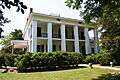
Marengo County Courthouse in Linden
|
|

Location within the U.S. state of Alabama
|
|
 Alabama's location within the U.S. |
|
| Country | |
| State | |
| Founded | February 6, 1818 |
| Named for | Battle of Marengo |
| Seat | Linden |
| Largest city | Demopolis |
| Area | |
| • Total | 983 sq mi (2,550 km2) |
| • Land | 977 sq mi (2,530 km2) |
| • Water | 5.8 sq mi (15 km2) 0.6% |
| Population
(2020)
|
|
| • Total | 19,323 |
| • Estimate
(2023)
|
18,684 |
| • Density | 19.657/sq mi (7.590/km2) |
| Time zone | UTC−6 (Central) |
| • Summer (DST) | UTC−5 (CDT) |
| Congressional district | 7th |
|
|
Marengo County is a county located in the west-central part of Alabama, a state in the United States. In 2020, about 19,323 people lived there. The biggest city in Marengo County is Demopolis, and the main government center, called the county seat, is Linden.
The county got its name from the Battle of Marengo. This was a famous battle near Turin, Italy, where the French leader Napoleon Bonaparte won against the Austrians on June 14, 1800.
Contents
History of Marengo County
Marengo County was officially created on February 6, 1818. This happened when the Alabama Territorial government set aside land. This land was originally from the Choctaw people, who had agreed to give it up in a treaty in 1816. Over the next 20 years, many Choctaw people, along with other Native American tribes, were moved to lands west of the Mississippi River, in what is now Oklahoma. This period is known as the Indian Removal.
How Marengo County Got Its Name
The county was named to remember Napoleon's big win at the Battle of Marengo. This name was chosen to honor the first European settlers in the area. These were French people who had to leave France after Napoleon's power ended. In 1817, many French families settled near Demopolis. They hoped to start a "Vine and Olive Colony" to grow grapes and olives. Other French people who came here were refugees from Saint-Domingue (now Haiti). They had left after enslaved Africans and free people of color fought for and won their independence in 1804.
Changing the County Seat's Name
The county seat was first called the Town of Marengo. But in 1823, its name was changed to Linden. Linden is a shorter version of Hohenlinden, which was the site of another French victory in Bavaria in 1800, also during Napoleon's time.
Farming and People in the Past
Marengo County is in a part of Alabama known as the Black Belt. This area has very rich soil. Because of this, many large cotton farms, called plantations, were built here. These farms relied on the forced labor of enslaved African Americans. Before the American Civil War, most people in the county were enslaved. In 1860, there were 24,409 enslaved people and 6,761 free white people. There was also one free person of color.
After the Civil War, farming remained important. Many formerly enslaved people became sharecroppers or tenant farmers. This allowed them to work for themselves instead of in large groups controlled by others.
Changes Over Time
The number of people living in Marengo County started to go down during and after World War II. Many people moved away from farms to find factory jobs, especially in places where defense industries were growing. This movement of African Americans from the South to other parts of the country is known as the Great Migration. From 1940 to 1970, about 5 million African Americans left the South. They were looking for better jobs and better living conditions, away from the unfair laws and treatment they faced in Alabama and other Southern states.
Over time, many cotton fields were changed into pastures for cattle and horses. Some became tree plantations for wood and paper, and others were turned into ponds for farming catfish. Starting in the 1960s, new industries came to the area, like paper mills, lumber mills, and chemical plants.
The county courthouse had fires in 1848 and 1965. Luckily, most of the important court records were saved each time because they were kept in a safe vault.
Geography of Marengo County
Marengo County is located in the west-central part of Alabama. The United States Census Bureau says the county covers about 983 square miles. Most of this (977 square miles) is land, and a small part (5.8 square miles) is water. The entire western edge of the county is formed by the Tombigbee River. A small part of the northwestern border is formed by the Black Warrior River.
Main Roads in Marengo County
 U.S. Highway 43
 U.S. Highway 80
 State Route 5
 State Route 10
 State Route 25
 State Route 28
 State Route 69
Neighboring Counties
Marengo County shares borders with these other counties:
- Hale County (north)
- Perry County (northeast)
- Dallas County (east)
- Wilcox County (southeast)
- Clarke County (south)
- Choctaw County (southwest)
- Sumter County (northwest)
- Greene County (north-northwest)
People and Population
In 2020, the census showed that 19,323 people lived in Marengo County. There were 7,361 households and 3,833 families.
Population by Race and Ethnicity (2020)
The table below shows the different racial and ethnic groups in Marengo County based on the 2020 census.
| Race / Ethnicity (NH = Non-Hispanic) | Pop 2000 | Pop 2010 | Pop 2020 | % 2000 | % 2010 | % 2020 |
|---|---|---|---|---|---|---|
| White alone (NH) | 10,582 | 9,607 | 8,375 | 46.95% | 45.69% | 43.34% |
| Black or African American alone (NH) | 11,581 | 10,838 | 10,133 | 51.38% | 51.54% | 52.44% |
| Native American or Alaska Native alone (NH) | 19 | 31 | 6 | 0.08% | 0.15% | 0.03% |
| Asian alone (NH) | 37 | 53 | 54 | 0.16% | 0.25% | 0.28% |
| Pacific Islander alone (NH) | 2 | 9 | 1 | 0.01% | 0.04% | 0.01% |
| Other race alone (NH) | 8 | 1 | 41 | 0.04% | 0.00% | 0.21% |
| Mixed race or Multiracial (NH) | 91 | 136 | 345 | 0.40% | 0.65% | 1.79% |
| Hispanic or Latino (any race) | 219 | 352 | 368 | 0.97% | 1.67% | 1.90% |
| Total | 22,539 | 21,027 | 19,323 | 100.00% | 100.00% | 100.00% |
Education in Marengo County
For the 2014–15 school year, the Marengo County School District ran three schools for all grades (K–12). These schools were in Dixons Mills, Sweet Water, and Thomaston. One school near Demopolis was closed after the 2013–14 school year. The cities of Demopolis and Linden have their own school systems: the Demopolis City School District and Linden City Schools.
Culture and Fun Things to Do
Local Events
Marengo County hosts several fun events throughout the year:
- Candlelight Evening at Gaineswood, part of Christmas in the Canebrake, in Demopolis
- Christmas on the River in Demopolis
- Faunsdale Biker Rally in Faunsdale
- Alabama Crawfish Festival in Faunsdale
- Harvest Festival in Demopolis
- Historic Demopolis Spring Pilgrimage in Demopolis
- Pepper Jelly Festival in Thomaston
- Southern Literary Trail in Demopolis
Places to Visit
Marengo County has many interesting places to explore:
- The Alabama Rural Heritage Center
- Chickasaw State Park
- The Tombigbee River and Black Warrior River are great for outdoor activities.
- There are 28 sites in Marengo County listed on the National Register of Historic Places. One of these is also a National Historic Landmark.
- Additionally, 19 sites are listed on the Alabama Register of Landmarks and Heritage.
Communities in Marengo County
Cities
Towns
Census-Designated Places
These are areas identified by the census for statistical purposes:
Unincorporated Communities
These are smaller communities without their own local government:
- Aimwell
- Alfalfa
- Beaver Creek
- Clayhill
- Consul
- Coxheath
- Dixons Mills
- Exmoor
- Half Acre
- Half Chance
- Hampden
- Hoboken
- Hugo
- Jefferson
- Lasca
- McKinley
- Magnolia
- Marengo
- Moores Valley
- Moscow
- Nicholsville
- Octagon
- Old Spring Hill
- Pin Hook
- Pope
- Rembert
- Salt Well
- Shiloh
- Siddonsville
- Surginer
- Vangale
- Vineland
- Wayne
Ghost Town
Images for kids
-
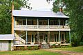
Barney's Upper Place, an I-house in Putnam built in 1833.
-
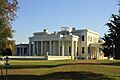
Gaineswood (built 1843–61), a National Historic Landmark in Demopolis.
-
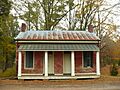
Boddie Law Office-Town Hall (built 1858) in Dayton. On the Alabama Register of Landmarks and Heritage.
-
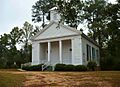
Jefferson Methodist Church (built 1856) in Jefferson. Part of the Jefferson Historic District.
-
Lyon Hall (built 1853) in Demopolis. On the National Register of Historic Places.


See also
 In Spanish: Condado de Marengo para niños
