Thomaston, Alabama facts for kids
Quick facts for kids
Thomaston, Alabama
|
|
|---|---|

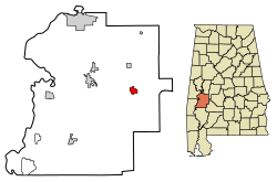
Location in Marengo County, Alabama
|
|
| Country | United States |
| State | Alabama |
| County | Marengo |
| Area | |
| • Total | 2.01 sq mi (5.2 km2) |
| • Land | 2.01 sq mi (5.2 km2) |
| • Water | 0.00 sq mi (0 km2) |
| Elevation | 187 ft (57 m) |
| Population
(2020)
|
|
| • Total | 326 |
| • Density | 161.95/sq mi (62.53/km2) |
| Time zone | UTC-6 (Central (CST)) |
| • Summer (DST) | UTC-5 (CDT) |
| ZIP code |
36783
|
| Area code(s) | 334 |
| FIPS code | 01-75936 |
| GNIS feature ID | 0127881 |
Thomaston is a small town located in Marengo County, Alabama, in the United States. In 2020, about 326 people lived there. This was a bit less than the 417 people who lived there in 2010.
Contents
History of Thomaston
Thomaston was planned out in 1901. This happened when the railroad was built to reach that area. The town got its name from C. B. Thomas, who helped promote the town. A post office has been open in Thomaston since 1892. The town officially became a town on November 15, 1901.
Historic Places to Visit
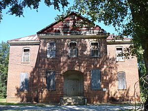
Thomaston has a special area called the Thomaston Central Historic District. This district covers the main part of the town. There are also three important buildings listed on the National Register of Historic Places. These are the Thomaston Colored Institute, the C. S. Golden House, and the Patrick Farrish House.
The town was once home to the Alabama Rural Heritage Center. It also had the Thomaston Community Market. Both of these were community projects by Auburn University's Rural Studio. Thomaston is also where you can find the Alabama Whitetail Records Museum.
Geography and Location
Thomaston is in the eastern part of Marengo County. It is located at 32.269495 degrees North and 87.624865 degrees West. Alabama State Route 28 (also called Second Avenue) goes through the town. This road leads west about 11 miles to Linden, which is the county seat. It also goes southeast about 30 miles to Camden.
Alabama State Route 25 (Range Street) crosses State Route 28 in the middle of Thomaston. This road goes north about 32 miles to Greensboro. It also goes south about 29 miles to Thomasville.
Land and Water Around Thomaston
According to the U.S. Census Bureau, Thomaston covers a total area of 2.0 square miles. All of this area is land. There is no water within the town limits. The town's water drains west into Michigan Creek. This creek then flows north into Chickasaw Bogue. Both are part of the larger Tombigbee River system.
Population and People
The number of people living in Thomaston has changed over the years.
| Historical population | |||
|---|---|---|---|
| Census | Pop. | %± | |
| 1910 | 309 | — | |
| 1920 | 372 | 20.4% | |
| 1930 | 377 | 1.3% | |
| 1940 | 345 | −8.5% | |
| 1950 | 1,027 | 197.7% | |
| 1960 | 857 | −16.6% | |
| 1970 | 824 | −3.9% | |
| 1980 | 679 | −17.6% | |
| 1990 | 497 | −26.8% | |
| 2000 | 383 | −22.9% | |
| 2010 | 417 | 8.9% | |
| 2020 | 326 | −21.8% | |
| U.S. Decennial Census 2013 Estimate |
|||
Who Lives in Thomaston?
In 2020, the town of Thomaston had 326 residents.
| Race / Ethnicity (NH = Non-Hispanic) | Pop 2010 | Pop 2020 | % 2010 | % 2020 |
|---|---|---|---|---|
| White alone (NH) | 183 | 164 | 43.88% | 50.31% |
| Black or African American alone (NH) | 222 | 159 | 53.24% | 48.77% |
| Native American or Alaska Native alone (NH) | 6 | 0 | 1.44% | 0.00% |
| Asian alone (NH) | 2 | 0 | 0.48% | 0.00% |
| Pacific Islander alone (NH) | 0 | 0 | 0.00% | 0.00% |
| Some Other Race alone (NH) | 0 | 0 | 0.00% | 0.00% |
| Mixed Race or Multi-Racial (NH) | 3 | 3 | 0.72% | 0.92% |
| Hispanic or Latino (any race) | 1 | 0 | 0.24% | 0.00% |
| Total | 417 | 326 | 100.00% | 100.00% |
In 2000, there were 383 people living in Thomaston. There were 163 households, which means 163 homes where people lived. About 105 of these were families. The population density was about 190 people per square mile.
About 27% of the households had children under 18 living with them. About 39.9% were married couples. Around 23.3% were homes with a female head of household and no husband present. Also, 35% of households were not families.
The average household had 2.35 people. The average family had 3.01 people.
The population was spread out by age. About 24% were under 18 years old. About 21.9% were 65 years or older. The average age in the town was 40 years.
The median income for a household in the town was $25,972. For a family, the median income was $31,250. About 29.2% of the people in Thomaston lived below the poverty line. This included 43.2% of those under 18 and 33.8% of those 65 or older.
Education in Thomaston
Amelia L. Johnson High School is a public school in Thomaston. It serves students from pre-kindergarten all the way to high school. It is one of three high schools in Marengo County. Most of the students at this school are African American. Many students also come from families with lower incomes.
See also
 In Spanish: Thomaston (Alabama) para niños
 | Delilah Pierce |
 | Gordon Parks |
 | Augusta Savage |
 | Charles Ethan Porter |


