Thomasville, Alabama facts for kids
Quick facts for kids
Thomasville
|
|||
|---|---|---|---|
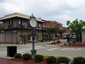
Downtown Thomasville in 2008.
|
|||
|
|||
| Nickname(s):
The City of Roses
|
|||
| Motto(s):
"Southwest Alabama's Success Story"
|
|||
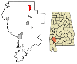
Location of Thomasville in Clarke County, Alabama.
|
|||
| Country | United States | ||
| State | Alabama | ||
| County | Clarke | ||
| Founded | 1888 | ||
| Area | |||
| • Total | 8.73 sq mi (22.62 km2) | ||
| • Land | 8.73 sq mi (22.61 km2) | ||
| • Water | 0.00 sq mi (0.00 km2) | ||
| Elevation | 381 ft (116 m) | ||
| Population
(2020)
|
|||
| • Total | 3,649 | ||
| • Density | 417.94/sq mi (161.37/km2) | ||
| Time zone | UTC-6 (Central (CST)) | ||
| • Summer (DST) | UTC-5 (CDT) | ||
| ZIP codes |
36762, 36784
|
||
| Area code(s) | 334 | ||
| FIPS code | 01-75960 | ||
| GNIS feature ID | 0153683 | ||
| Website | City of Thomasville | ||
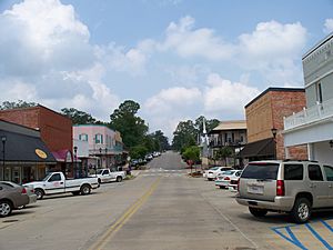
Thomasville is a city in Clarke County, Alabama, United States. In 2020, about 3,649 people lived there. It started as a railroad town in the late 1800s. Over time, it has grown into a busy center for businesses. The famous storyteller and author Kathryn Tucker Windham grew up in Thomasville.
Contents
History of Thomasville
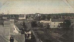
Thomasville was started in 1888. It became an official city on November 24 of that year. Before Thomasville, there was a community called Choctaw Corner. This older town was west of where Thomasville is now. When people in Choctaw Corner heard a railroad would pass east of their town, they moved their shops. They wanted to be close to the new railroad. Today, the old Choctaw Corner area is part of Thomasville.
The railroad tracks between Mobile and Selma were finished in the same year Thomasville began. The town was first called "Choctaw." It was later named after Samuel Russell Thomas. He was a railroad investor and a general in the Union during the Civil War. He gave $500 to build Thomasville's first school. By the end of the 1800s, the town had many stores, hotels, and a train station.
In 1899, a big fire destroyed much of downtown Thomasville. Many wooden buildings burned down. But Thomasville quickly rebuilt, this time using bricks. The town was thriving again by the start of World War I.
Over the next 100 years, Thomasville kept growing. Many businesses came and went. These included clothing factories, sawmills, and cotton gins. The railroad stopped using the town's depot in the 1950s. But in the 1950s, a radar base opened in Thomasville. This base was part of the Air Defense Command. It brought many military families to the area. The first FPS-35 radar was developed at the Thomasville Aircraft Control and Warning Station.
Also in the 1950s, roses were planted along Highway 43. This is the main highway through Thomasville. This is how the city got its nickname, "The City of Roses." In the 1960s and 1970s, many paper mills opened nearby. This industry is still very important to Thomasville's economy today. During this time, businesses also started moving from downtown to the main highway. In 1999, the Thomasville Historic District was recognized for its important history.
Geography and Climate
Thomasville is located at 31°55′15″N 87°44′24″W / 31.92084°N 87.74008°W. It is the northernmost city in Clarke County. The city sits on high ground between the Tombigbee and Alabama rivers. Its elevation is about 116 meters (381 feet) above sea level. The land has gentle rolling hills and is mostly covered with pine forests. The city covers about 22.6 square kilometers (8.8 square miles) of land.
Climate in Thomasville
The weather in Thomasville has hot, humid summers. Winters are usually mild to cool. This type of weather is called a humid subtropical climate. It is often shown as "Cfa" on climate maps.
| Climate data for Thomasville, Alabama, 1991–2020 normals, extremes 1891–present | |||||||||||||
|---|---|---|---|---|---|---|---|---|---|---|---|---|---|
| Month | Jan | Feb | Mar | Apr | May | Jun | Jul | Aug | Sep | Oct | Nov | Dec | Year |
| Record high °F (°C) | 86 (30) |
86 (30) |
97 (36) |
94 (34) |
102 (39) |
108 (42) |
107 (42) |
105 (41) |
109 (43) |
100 (38) |
91 (33) |
90 (32) |
109 (43) |
| Mean maximum °F (°C) | 74.7 (23.7) |
77.3 (25.2) |
83.1 (28.4) |
86.1 (30.1) |
91.5 (33.1) |
94.8 (34.9) |
96.0 (35.6) |
96.3 (35.7) |
93.9 (34.4) |
88.9 (31.6) |
80.8 (27.1) |
75.8 (24.3) |
97.5 (36.4) |
| Mean daily maximum °F (°C) | 58.8 (14.9) |
63.1 (17.3) |
70.8 (21.6) |
77.5 (25.3) |
84.9 (29.4) |
89.6 (32.0) |
91.6 (33.1) |
91.8 (33.2) |
88.1 (31.2) |
79.0 (26.1) |
68.5 (20.3) |
60.6 (15.9) |
77.0 (25.0) |
| Daily mean °F (°C) | 47.9 (8.8) |
51.7 (10.9) |
58.7 (14.8) |
65.3 (18.5) |
73.3 (22.9) |
79.3 (26.3) |
81.5 (27.5) |
81.2 (27.3) |
77.0 (25.0) |
66.9 (19.4) |
56.7 (13.7) |
49.9 (9.9) |
65.8 (18.8) |
| Mean daily minimum °F (°C) | 37.0 (2.8) |
40.3 (4.6) |
46.7 (8.2) |
53.0 (11.7) |
61.8 (16.6) |
68.9 (20.5) |
71.5 (21.9) |
70.7 (21.5) |
65.9 (18.8) |
54.8 (12.7) |
45.0 (7.2) |
39.1 (3.9) |
54.6 (12.5) |
| Mean minimum °F (°C) | 19.1 (−7.2) |
23.3 (−4.8) |
28.6 (−1.9) |
36.5 (2.5) |
47.2 (8.4) |
59.6 (15.3) |
65.6 (18.7) |
63.3 (17.4) |
53.3 (11.8) |
37.9 (3.3) |
27.6 (−2.4) |
23.7 (−4.6) |
17.1 (−8.3) |
| Record low °F (°C) | −1 (−18) |
−5 (−21) |
14 (−10) |
27 (−3) |
36 (2) |
46 (8) |
54 (12) |
51 (11) |
35 (2) |
26 (−3) |
14 (−10) |
3 (−16) |
−5 (−21) |
| Average precipitation inches (mm) | 5.48 (139) |
4.63 (118) |
5.65 (144) |
4.01 (102) |
4.05 (103) |
4.60 (117) |
6.00 (152) |
4.83 (123) |
4.27 (108) |
3.96 (101) |
4.75 (121) |
5.26 (134) |
57.49 (1,462) |
| Average snowfall inches (cm) | 0.0 (0.0) |
0.0 (0.0) |
0.0 (0.0) |
0.0 (0.0) |
0.0 (0.0) |
0.0 (0.0) |
0.0 (0.0) |
0.0 (0.0) |
0.0 (0.0) |
0.0 (0.0) |
0.0 (0.0) |
0.1 (0.25) |
0.1 (0.25) |
| Average precipitation days (≥ 0.01 in) | 10.6 | 9.2 | 8.7 | 7.6 | 8.1 | 9.9 | 12.1 | 10.2 | 8.3 | 6.8 | 8.3 | 9.8 | 109.6 |
| Average snowy days (≥ 0.1 in) | 0.0 | 0.0 | 0.0 | 0.0 | 0.0 | 0.0 | 0.0 | 0.0 | 0.0 | 0.0 | 0.0 | 0.0 | 0.0 |
| Source 1: NOAA | |||||||||||||
| Source 2: NWS/XMACIS2 | |||||||||||||
Population of Thomasville
| Historical population | |||
|---|---|---|---|
| Census | Pop. | %± | |
| 1890 | 291 | — | |
| 1900 | 686 | 135.7% | |
| 1910 | 1,181 | 72.2% | |
| 1920 | 1,002 | −15.2% | |
| 1930 | 1,504 | 50.1% | |
| 1940 | 2,000 | 33.0% | |
| 1950 | 2,425 | 21.3% | |
| 1960 | 3,182 | 31.2% | |
| 1970 | 3,769 | 18.4% | |
| 1980 | 4,387 | 16.4% | |
| 1990 | 4,301 | −2.0% | |
| 2000 | 4,649 | 8.1% | |
| 2010 | 4,209 | −9.5% | |
| 2020 | 3,649 | −13.3% | |
| U.S. Decennial Census 2013 Estimate |
|||
2020 Census Information
| Race | Num. | Perc. |
|---|---|---|
| White | 1,582 | 43.35% |
| Black or African American | 1,937 | 53.08% |
| Native American | 5 | 0.14% |
| Asian | 15 | 0.41% |
| Other/Mixed | 78 | 2.14% |
| Hispanic or Latino | 32 | 0.88% |
In 2020, Thomasville had 3,649 people. There were 1,659 households and 792 families living in the city.
2010 Census Information
In 2010, there were 4,209 people living in Thomasville. There were 1,737 households. About 30.1% of these households had children under 18. The average household had 2.38 people. The average family had 3.00 people.
The population was spread out by age. About 29% were under 20 years old. About 45.3% were between 20 and 64 years old. And 16.3% were 65 years or older. The average age was 38.4 years.
Economy and Jobs
Thomasville's economy mainly relies on stores and services. It is a key business center for the area. This means many people from nearby towns come to Thomasville to shop and find services.
Education in Thomasville
Thomasville has its own public school system. It is called the Thomasville City School System. It includes three schools:
- Thomasville Elementary School (for Pre-K to 4th grade)
- Thomasville Middle School
- Thomasville High School
Thomasville Elementary School is located at 300 Quincy Ingram Street. It opened at its current spot in 1988. A gym and a new wing were added in 1990. In 1997, a kindergarten wing was built. The school serves about 500 students daily. It has many classrooms for each grade level. There are 54 teachers and staff members. All Thomasville City Schools meet Alabama's goals for student success.
Thomasville also has a campus of Coastal Alabama Community College. This college offers two-year programs. It serves students in southwest Alabama.
Healthcare Services

Thomasville has a new hospital called Thomasville Regional Medical Center. It opened on March 3, 2020. This hospital has 29 beds for patients who need acute care.
There is also a nursing home in Thomasville. It is called Thomasville Nursing Home. It has 70 beds for long-term care. It is located on Mosley Drive.
Media and News
Print Media
Thomasville has one newspaper, the Thomasville Times. It started in 1921.
Radio Stations
Thomasville has two FM radio stations. They are WDLG and WJDB-FM.
Museums and Libraries
The Thomasville campus of Alabama Southern Community College has the Kathryn Tucker Windham Museum. This museum honors the famous storyteller.
The Thomasville Public Library is also in the city. It has many books, audio materials, and videos.
Notable People from Thomasville
- Eric Campbell, a professional basketball player.
- Reid Cornelius, a former Major League Baseball player. He is now a pitching coach.
- Ivy Griffin, a former Major League Baseball player.
- Anthony Madison, a former National Football League player.
- Monroe Parker, a Baptist evangelist and college president.
- Lynwood Lowry Spinks, co-founder of Relativity Media. He was an executive producer for movies like 3:10 to Yuma and The Fast and the Furious: Tokyo Drift.
- Kathryn Tucker Windham, a famous storyteller and author.
See also
 In Spanish: Thomasville (Alabama) para niños
 | Precious Adams |
 | Lauren Anderson |
 | Janet Collins |


