Clarke County, Alabama facts for kids
Quick facts for kids
Clarke County
|
||
|---|---|---|

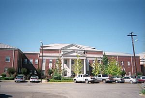
Clarke County Courthouse in Grove Hill
|
||
|
||

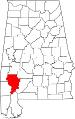
Location within the U.S. state of Alabama
|
||
 Alabama's location within the U.S. |
||
| Country | ||
| State | ||
| Founded | December 10, 1812 | |
| Named for | John Clarke | |
| Seat | Grove Hill | |
| Largest city | Jackson | |
| Area | ||
| • Total | 1,253 sq mi (3,250 km2) | |
| • Land | 1,238 sq mi (3,210 km2) | |
| • Water | 14 sq mi (40 km2) 1.1% | |
| Population
(2020)
|
||
| • Total | 23,087 | |
| • Estimate
(2023)
|
22,337 |
|
| • Density | 18.425/sq mi (7.1141/km2) | |
| Time zone | UTC−6 (Central) | |
| • Summer (DST) | UTC−5 (CDT) | |
| Congressional district | 7th | |
|
||
Clarke County is a county in the southwestern part of Alabama. In 2020, about 23,087 people lived there. The main town, or county seat, is Grove Hill. The biggest city in the county is Jackson.
The county was created in 1812 by the Mississippi Territory. It is named after General John Clarke from Georgia. He later became the governor of Georgia. You can visit the county museum in the Alston-Cobb House in Grove Hill.
Contents
History
Early Times
For thousands of years, different groups of indigenous peoples lived along the rivers in this area. When Europeans first arrived, the Choctaw and Creek people called Clarke County home. They traded with French settlers from Mobile and New Orleans. They also traded with English and Scottish traders from the British colonies. Later, after the United States bought the Louisiana territory, these groups started to build relationships with the U.S. government.
In 1805, the Choctaw people signed a treaty called the Treaty of Mount Dexter. This treaty gave a lot of their land to the United States. This land included much of what is now western Clarke County.
Modern History
Clarke County was officially formed on December 10, 1812. During the Creek War (1813–1814), settlers built many forts for protection. Some of these forts included Fort Carney, Fort Easley, Fort Glass, Fort Landrum, Fort Madison, Fort Sinquefield, Turner's Fort, and Fort White.
The first county seat was Clarkesville, started in 1820. The county seat later moved to Macon in 1831, which was then renamed Grove Hill. In 1892, Clarke County saw a conflict over economic issues, known as the Mitcham War.
Salt Production
Clarke County has many salt springs. People have used these springs to get salt since as early as 1100 AD. During the American Civil War, salt from these springs became very important. This was because the Union Navy blocked Southern ports, making it hard to get salt.
In 1862, the county government set aside money to make salt at the springs. The State of Alabama also ran several salt works during the war. These places had homes for workers, hospitals, and cemeteries. The salt was used by both soldiers and regular people. Forts were built at Oven Bluff (Fort Sidney Johnston) and Carney Bluff (Fort Gullett) to protect the salt works. Another fort, Fort Stonewall, was built at Choctaw Bluff to protect the Alabama River.
Geography
Clarke County covers about 1,253 square miles. Most of this (1,238 square miles) is land, and about 14 square miles (1.1%) is water. It is the third-largest county in Alabama by land area.
Main Roads
Neighboring Counties
- Marengo County (north)
- Wilcox County (northeast)
- Monroe County (east)
- Baldwin County (south)
- Washington County (southwest)
- Choctaw County (northwest)
Population Information
| Historical population | |||
|---|---|---|---|
| Census | Pop. | %± | |
| 1820 | 5,839 | — | |
| 1830 | 7,595 | 30.1% | |
| 1840 | 8,640 | 13.8% | |
| 1850 | 9,786 | 13.3% | |
| 1860 | 15,049 | 53.8% | |
| 1870 | 14,663 | −2.6% | |
| 1880 | 17,806 | 21.4% | |
| 1890 | 22,624 | 27.1% | |
| 1900 | 27,790 | 22.8% | |
| 1910 | 30,987 | 11.5% | |
| 1920 | 26,409 | −14.8% | |
| 1930 | 26,016 | −1.5% | |
| 1940 | 27,636 | 6.2% | |
| 1950 | 26,548 | −3.9% | |
| 1960 | 25,738 | −3.1% | |
| 1970 | 26,724 | 3.8% | |
| 1980 | 27,702 | 3.7% | |
| 1990 | 27,240 | −1.7% | |
| 2000 | 27,867 | 2.3% | |
| 2010 | 25,833 | −7.3% | |
| 2020 | 23,087 | −10.6% | |
| 2023 (est.) | 22,337 | −13.5% | |
| U.S. Decennial Census 1790–1960 1900–1990 1990–2000 2010–2020 |
|||
Recent Population Data
As of the 2020 United States census, Clarke County had 23,087 people. There were 9,090 households and 5,662 families living in the county.
In 2020, the population was made up of:
- About 51.85% White people
- About 44.28% Black or African American people
- Other groups made up smaller percentages.
In 2010, the population was 25,833. About 54.5% were White and 43.9% were Black.
In 2000, there were 27,867 people. About 55.94% were White and 43.02% were Black or African American. The average household had 2.60 people. About 28% of the population was under 18 years old. The median age was 36 years.
Education
Clarke County has two public school districts. Around 3,400 students attend public schools from pre-kindergarten through 12th grade.
School Districts
- Clarke County School District
- Thomasville City School District
Communities
Cities
Towns
- Coffeeville
- Fulton
- Grove Hill (county seat)
Census Designated Places
Unincorporated Communities
Former Communities
Notable People
- Loraine Bedsole Bush Tunstall (1881-1953), a social reformer who worked to improve society.
- Martha Loftin Wilson (1834–1919), a missionary worker and journal editor.
See also
 In Spanish: Condado de Clarke (Alabama) para niños
 | William L. Dawson |
 | W. E. B. Du Bois |
 | Harry Belafonte |


