
Greene County, Alabama facts for kids
Quick facts for kids
Greene County
|
||
|---|---|---|

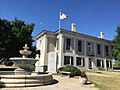
Greene County Courthouse in Eutaw
|
||
|
||

Location within the U.S. state of Alabama
|
||
 Alabama's location within the U.S. |
||
| Country | ||
| State | ||
| Founded | December 13, 1819 | |
| Named for | Nathanael Greene | |
| Seat | Eutaw | |
| Largest city | Eutaw | |
| Area | ||
| • Total | 660 sq mi (1,700 km2) | |
| • Land | 647 sq mi (1,680 km2) | |
| • Water | 13 sq mi (30 km2) 1.9% | |
| Population
(2020)
|
||
| • Total | 7,730 | |
| • Estimate
(2023)
|
7,341 |
|
| • Density | 11.71/sq mi (4.52/km2) | |
| Time zone | UTC−6 (Central) | |
| • Summer (DST) | UTC−5 (CDT) | |
| Congressional district | 7th | |
|
||
Greene County is a county in west-central Alabama. In 2020, it had 7,730 people, making it the least populated county in Alabama. The main town and county seat is Eutaw.
The county is named after General Nathanael Greene from Rhode Island. He was a hero in the American Revolutionary War. In 2020, about 81% of the people in Greene County were African American. This makes it one of the counties with the highest percentage of Black residents in the United States.
Contents
History of Greene County
Greene County was created on December 13, 1819. The town of Eutaw became the county seat in 1838. It was chosen because it was more central than the old seat, Erie. Being the center of government helped Eutaw grow.
Reconstruction Era (1865–1876)
After the American Civil War, the period known as Reconstruction began. In 1867, a new county called Hale County was formed. It took land from the eastern part of Greene County. During this time, white groups tried to keep control over Black citizens. Black people made up most of the population in Greene County.
In 1868, the Greene County Courthouse in Eutaw was burned down. Many people believe this was done to destroy records. These records were for lawsuits filed by newly freed Black people against landowners.
There were also violent attacks in 1870. James Martin, a Black Republican leader, was shot and disappeared. Alexander Boyd, a white Republican lawyer, was murdered by the Ku Klux Klan in Eutaw. The Ku Klux Klan was a secret group that used violence to scare Black people and their supporters.
Even though the governor sent an agent to investigate, no one was charged for these crimes. Before the 1870 election, more Black Republicans were killed. At a large meeting in Eutaw, white Klansmen attacked the crowd. At least four Black people died and 54 were hurt. After this, many Black citizens were too scared to vote.
Civil Rights Era (1964–1970)
The Civil Rights Movement brought big changes. On July 30, 1969, Greene County made history. It became the first county in the South since Reconstruction where Black leaders controlled both the county commission and the school board.
This happened after a special election was ordered by a federal court. African American candidates won most of the seats. This event was a major step for Black political power in Alabama. It showed that African American candidates could win elections and govern counties where white residents were a minority.
Geography of Greene County
Greene County covers about 660 square miles. Most of this area is land, with about 13 square miles of water.
The county's borders are mostly shaped by three important rivers: the Tombigbee, Black Warrior, and Sipsey Rivers. Much of the county is made up of the valleys around these rivers.
Major Highways

 Interstate 20/Interstate 59
 U.S. Route 11
 U.S. Route 43
 State Route 14
 State Route 39
Neighboring Counties
- Pickens County (north)
- Tuscaloosa County (northeast)
- Hale County (east)
- Marengo County (south)
- Sumter County (southwest)
Population Changes
In 1867, part of Greene County was used to create Hale County. This caused a big drop in Greene County's population. Later, in the 1900s, many people moved away from rural areas to cities. This led to more population loss.
| Historical population | |||
|---|---|---|---|
| Census | Pop. | %± | |
| 1820 | 4,554 | — | |
| 1830 | 15,026 | 230.0% | |
| 1840 | 24,024 | 59.9% | |
| 1850 | 31,441 | 30.9% | |
| 1860 | 30,859 | −1.9% | |
| 1870 | 18,399 | −40.4% | |
| 1880 | 21,931 | 19.2% | |
| 1890 | 22,007 | 0.3% | |
| 1900 | 24,182 | 9.9% | |
| 1910 | 22,717 | −6.1% | |
| 1920 | 18,133 | −20.2% | |
| 1930 | 19,745 | 8.9% | |
| 1940 | 19,185 | −2.8% | |
| 1950 | 16,482 | −14.1% | |
| 1960 | 13,600 | −17.5% | |
| 1970 | 10,650 | −21.7% | |
| 1980 | 11,021 | 3.5% | |
| 1990 | 10,153 | −7.9% | |
| 2000 | 9,974 | −1.8% | |
| 2010 | 9,045 | −9.3% | |
| 2020 | 7,730 | −14.5% | |
| 2023 (est.) | 7,341 | −18.8% | |
| U.S. Decennial Census 1790–1960 1900–1990 1990–2000 2010–2020 |
|||
As of the 2020 United States census, Greene County had 7,730 residents. Most of the population, about 80.56%, identified as Black or African American. About 16.62% identified as White.
Towns and Communities
Greene County has one city and several towns and smaller communities.
City
- Eutaw (This is the county seat, where the main government offices are.)
Towns
Unincorporated Communities
These are smaller places that are not officially organized as cities or towns.
Images for kids
-
Greene County Courthouse in Eutaw
See also
 In Spanish: Condado de Greene (Alabama) para niños
